
Trailforks
Kupovina unutar aplikacije
4,7star
11,5 hilj. recenzija
1 mil.+
Preuzimanja

Tinejdžeri
info

O aplikaciji
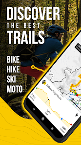
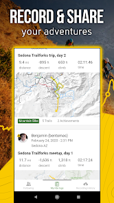
Plan the ultimate bike ride with Trailforks. Explore the best of mountain biking, moto dirtbiking, fatbiking, skiing, trail running, and more with the backcountry navigator made for all your winter off-road adventures. Get a bike tracker with detailed trail maps, condition reports, and route planning tools all in Trailforks.
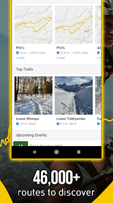
Wintery exploration is complete with 630,000+ trails in your pocket, perfect for your next biking adventure, cycling training, and everything in between. Get a bike ride tracker filled with accurate, up-to-date stats and info for all of your rides. Download today and get started.
THE BEST OF CYCLING APPS
- The ultimate biking app with the world’s largest trail database
- Bike route options for winter biking, fat biking, cyclocross and more
- Bike GPS with GPX compatibility. Sync your Garmin or Wahoo device
- Download free cycling maps and create local routes during your bike ride
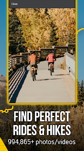
- View bike route & region info with 1 million photos, videos, and 3M trail reports
- Get a free cycling app with quick links and directions to nearby bike shops
- Cycle through fatbike trails and backcountry routes
- Get a cycling tracker with bike route info & average time to complete
MULTI-ACTIVITY SUPPORT
- Fatbike, cycle, & more!
- Not just for bikers – find routes for hiking, trail running, skiing, and more.
- Free maps with thousands of related activity points of interest (POIs).
- Topo maps are yours to prepare for your next outdoor adventure
- Hiking Maps: Discover, plan and explore routes & trails
WINTER BIKING A BETTER WAY
- Prepare for your backroads bike ride with the help of Ridelogs
- Cycle & support areas you ride by donating to Trail Karma
- Discover bike routes for this year’s winter biking season and rate and comment
- Our free cycling app lets you share routes, rides & trails via QRCode
GPS NAVIGATION
- Enjoy bike GPS features for seamless navigation
- GPS with a bike ride tracker, run tracker & more – all in one
- Orientate road maps in the direction you’re facing
TOPOGRAPHIC MAPS AVAILABLE ONLINE & OFFLINE
- Offline topo maps and information with fast, incremental region updates
- Bike ride & hike with route elevation profiles displayed in-app
- Explore free maps with a growing list of routes
- Toggle Pro map layers like slope angle, light pollution, USFS, land ownership, avalanche data &more!
- Up your outdoor game when viewing Strava segments
- Overlay of US land owners like the BLM
- View polygons for private property or closed areas
- Get the best of cycling apps with route creation to your preferred trailhead
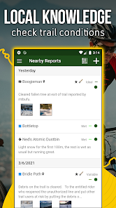
TRAIL EVENTS, STATUSES & ALERTS
- Save bike trails to your Wishlist
- View events nearby or by region
- Share your map location with friends & emergency services
- Your cycling tracker monitors and hiking trail conditions & closures
- Submit trail reports, including photos of trail issues
- Record each bike ride and earn local trail badges
- Sync and view saved 'Route Plans' from web to app
UPGRADE YOUR RIDE WITH TRAILFORKS PRO WITH OUTSIDE+
- Unlock nationwide map access, including Garmin base maps
- Priority sync with your Garmin or Strava device
- Enjoy unlimited waypoints & wishlists
- Access desktop-to-app biking tools like printmap & downloadable GPX & KML files
- Unlimited access to the Gaia GPS offroad & hiking app
- Expert-led online courses on Outside Learn
- Premium access to award-winning films, shows, and live TV on Outside Watch
- Unlimited digital access to Outside Network's 15 iconic brands including Outside Online, Velo, and Pinkbike
Trailforks is the perfect free cycling app for your outdoor adventures. Fatbike, winter bike and more this season alongside the Trailforks community today!
Detailed trail maps for renowned mountain biking destinations such as, Whistler, Squamish, North Shore, Kamloops, Nelson, Moab, Sedona, Park City, Hurricane, Downieville, Colorado Springs, Bellingham, Bentonville, Finale Ligure, Pisgah, Marin, Bend Oregon, Wellington & Rotorua New Zealand.
Wintery exploration is complete with 630,000+ trails in your pocket, perfect for your next biking adventure, cycling training, and everything in between. Get a bike ride tracker filled with accurate, up-to-date stats and info for all of your rides. Download today and get started.
THE BEST OF CYCLING APPS
- The ultimate biking app with the world’s largest trail database
- Bike route options for winter biking, fat biking, cyclocross and more
- Bike GPS with GPX compatibility. Sync your Garmin or Wahoo device
- Download free cycling maps and create local routes during your bike ride
- View bike route & region info with 1 million photos, videos, and 3M trail reports
- Get a free cycling app with quick links and directions to nearby bike shops
- Cycle through fatbike trails and backcountry routes
- Get a cycling tracker with bike route info & average time to complete
MULTI-ACTIVITY SUPPORT
- Fatbike, cycle, & more!
- Not just for bikers – find routes for hiking, trail running, skiing, and more.
- Free maps with thousands of related activity points of interest (POIs).
- Topo maps are yours to prepare for your next outdoor adventure
- Hiking Maps: Discover, plan and explore routes & trails
WINTER BIKING A BETTER WAY
- Prepare for your backroads bike ride with the help of Ridelogs
- Cycle & support areas you ride by donating to Trail Karma
- Discover bike routes for this year’s winter biking season and rate and comment
- Our free cycling app lets you share routes, rides & trails via QRCode
GPS NAVIGATION
- Enjoy bike GPS features for seamless navigation
- GPS with a bike ride tracker, run tracker & more – all in one
- Orientate road maps in the direction you’re facing
TOPOGRAPHIC MAPS AVAILABLE ONLINE & OFFLINE
- Offline topo maps and information with fast, incremental region updates
- Bike ride & hike with route elevation profiles displayed in-app
- Explore free maps with a growing list of routes
- Toggle Pro map layers like slope angle, light pollution, USFS, land ownership, avalanche data &more!
- Up your outdoor game when viewing Strava segments
- Overlay of US land owners like the BLM
- View polygons for private property or closed areas
- Get the best of cycling apps with route creation to your preferred trailhead
TRAIL EVENTS, STATUSES & ALERTS
- Save bike trails to your Wishlist
- View events nearby or by region
- Share your map location with friends & emergency services
- Your cycling tracker monitors and hiking trail conditions & closures
- Submit trail reports, including photos of trail issues
- Record each bike ride and earn local trail badges
- Sync and view saved 'Route Plans' from web to app
UPGRADE YOUR RIDE WITH TRAILFORKS PRO WITH OUTSIDE+
- Unlock nationwide map access, including Garmin base maps
- Priority sync with your Garmin or Strava device
- Enjoy unlimited waypoints & wishlists
- Access desktop-to-app biking tools like printmap & downloadable GPX & KML files
- Unlimited access to the Gaia GPS offroad & hiking app
- Expert-led online courses on Outside Learn
- Premium access to award-winning films, shows, and live TV on Outside Watch
- Unlimited digital access to Outside Network's 15 iconic brands including Outside Online, Velo, and Pinkbike
Trailforks is the perfect free cycling app for your outdoor adventures. Fatbike, winter bike and more this season alongside the Trailforks community today!
Detailed trail maps for renowned mountain biking destinations such as, Whistler, Squamish, North Shore, Kamloops, Nelson, Moab, Sedona, Park City, Hurricane, Downieville, Colorado Springs, Bellingham, Bentonville, Finale Ligure, Pisgah, Marin, Bend Oregon, Wellington & Rotorua New Zealand.
Ažurirano dana
Sigurnost počinje razumijevanjem na koji način programeri prikupljaju i dijele vaše podatke. Privatnost podataka i sigurnosne prakse se mogu razlikovati ovisno o korištenju, regiji i dobi. Programer je pružio ove informacije i može ih s vremenom ažurirati.

Ova aplikacija može dijeliti ove vrste podataka s trećim stranama
Aktivnost aplikacija, Informacije o aplikacijama i performanse i ID-ovi uređaja ili drugi ID-ovi

Ova aplikacija može prikupljati ove vrste podataka
Lokacija i Lične informacije

Podaci su šifrirani u prijenosu

Možete zatražiti da se podaci izbrišu
Ocjene i recenzije
4,7
11,2 hilj. recenzije

Ivan Prskalo
- Označavanje kao neprikladno
30. juli 2021.
As long as I was in signal coverage it was ok. As soon as went to Croatia, no internet there, wanted to explore the area and plan my way using this app - it was useless to me. Map was not detailed enough. I had it downloaded and it looks better when I have internet. I purchases it not to rely on internet. If I can get internet service everywhere I go I would stick with Google maps.
Šta ima novo
With this release, we introduce Smart Compass, a new way to always see the direction of the point, trail or any feature that you have selected, or even your actual location.
As often, we bring many small fixes to the app to improve your experience!
As often, we bring many small fixes to the app to improve your experience!


