
Wildfire - Fire Map Info
3,5star
82 ta sharh
1 ming+
Yuklanmalar

Hamma uchun
info


Bu ilova haqida
* The fastest way to view NOAA/USGS wildfire data *
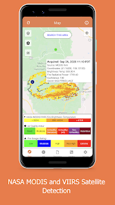
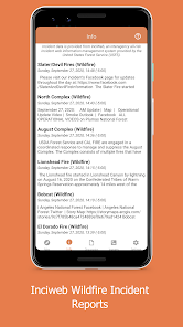
CURRENT WILDFIRES
View NASA's near-realtime MODIS and VIIRS I-band fire detection data coupled with the USGS fire perimeter analysis.
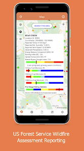
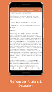
HAZARDOUS WILDFIRE CONDITION ZONES
View detailed NOAA and USGS discussions of on-going wildfires and conditions.
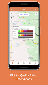
WEATHER DATA
View near-realtime weather data overlays, including NOAA HD Weather Radar, Long Duration Hazards, Short Duration Watches & Warnings, Wind Speeds and Directions, and much more!
NEWS AND ANALYSIS:
View Current National Incidents and updates from responding agencies as well as Analysis Graphics provided from various Federal Fire and Weather Agencies
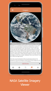
BEAUTIFUL BASE MAPS:
View data on Google Maps Normal, Satellite and Terrain Maps, USGS-provided Topographic maps or NASA Blue Marble maps!
CURRENT WILDFIRES
View NASA's near-realtime MODIS and VIIRS I-band fire detection data coupled with the USGS fire perimeter analysis.
HAZARDOUS WILDFIRE CONDITION ZONES
View detailed NOAA and USGS discussions of on-going wildfires and conditions.
WEATHER DATA
View near-realtime weather data overlays, including NOAA HD Weather Radar, Long Duration Hazards, Short Duration Watches & Warnings, Wind Speeds and Directions, and much more!
NEWS AND ANALYSIS:
View Current National Incidents and updates from responding agencies as well as Analysis Graphics provided from various Federal Fire and Weather Agencies
BEAUTIFUL BASE MAPS:
View data on Google Maps Normal, Satellite and Terrain Maps, USGS-provided Topographic maps or NASA Blue Marble maps!
Oxirgi yangilanish
Maʼlumotlar xavfsizligi
Dastur ishlab chiquvchilar shu yerda ilovasi maʼlumotlaringizni qanday qilib toʻplashi va undan qanday qilib foydalanishi haqida maʼlumot chiqarishi mumkin. Axborot xavfsizligi haqida batafsil

Hech qanday maʼlumot yoʻq
Reytinglar va sharhlar
3,5
74 ta sharh
Nima yangiliklar
Fixed a bug that prevented forecast discussion data from being downloaded.


