Maastokartat
In-app purchases
4.1star
21K reviews
500K+
Downloads

Everyone
info
About this app
Free topographic map enhances outdoor activities and aids in the exploration of new places. It enables you to effortlessly determine your location and understand your surroundings. You can save interesting places and navigate to various destinations. By subscribing to Maastokartat Plus, you gain access to valuable additional features, including high-definition topographic maps with elevation and depth details, 3D maps, property boundaries, route planning and tracking, offline maps, and location sharing.
Free features:
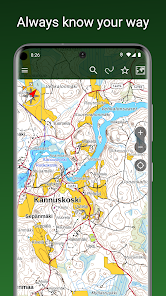
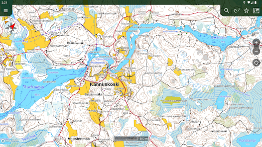
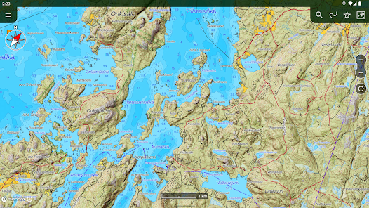
• Accurate topographic map based on data from the National Land Survey of Finland
• Aerial imagery from the National Land Survey of Finland
• Satellite images of the entire world
• Topographic maps of Sweden, Norway, Denmark, and Estonia
• Display and tracking of your location
• Coordinate display formats: WGS84, ETRS-TM35FIN, YKJ, KKJ, and MGRS
• Compass, map rotation based on direction of travel
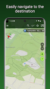
• Navigation to a destination, displaying direction and distance
• Place name search
• Distance measurement
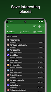
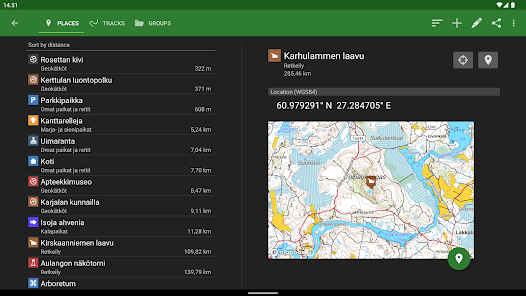
• Saving your own places
• Organizing places and routes into groups
• Sharing and importing places and routes as GPX files
• Backup to your personal Google Drive
• Heart rate monitoring with BLE heart rate sensors
Plus subscription additionally includes:
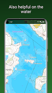
• Highly detailed topographic map with water depth information
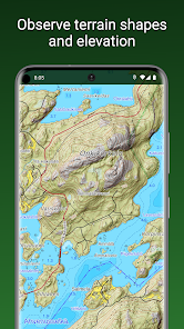
• Hillshaded topographic map clearly showing elevation differences
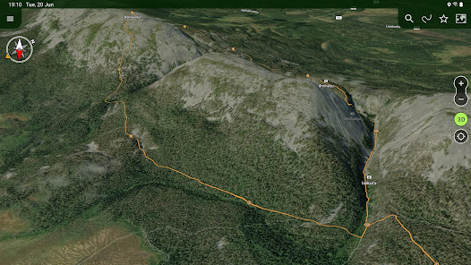
• 3D aerial and satellite imagery
• Worldwide outdoor map based on OpenStreetMap data
• Offline maps, preloading maps of selected areas into device memory for offline use
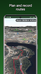
• Recording and displaying traveled routes, pre-planning of routes
• Drawing areas and measuring surface areas
• Sharing location among users, drawing another user's track on your own map
• Property boundaries and identifiers as separate map layers on top of other maps
The Plus subscription can be purchased as a one-time payment for €9.90 / 3 months or as a recurring subscription for €19.90 / year, which amounts to only €1.66 / month.
Free features:
• Accurate topographic map based on data from the National Land Survey of Finland
• Aerial imagery from the National Land Survey of Finland
• Satellite images of the entire world
• Topographic maps of Sweden, Norway, Denmark, and Estonia
• Display and tracking of your location
• Coordinate display formats: WGS84, ETRS-TM35FIN, YKJ, KKJ, and MGRS
• Compass, map rotation based on direction of travel
• Navigation to a destination, displaying direction and distance
• Place name search
• Distance measurement
• Saving your own places
• Organizing places and routes into groups
• Sharing and importing places and routes as GPX files
• Backup to your personal Google Drive
• Heart rate monitoring with BLE heart rate sensors
Plus subscription additionally includes:
• Highly detailed topographic map with water depth information
• Hillshaded topographic map clearly showing elevation differences
• 3D aerial and satellite imagery
• Worldwide outdoor map based on OpenStreetMap data
• Offline maps, preloading maps of selected areas into device memory for offline use
• Recording and displaying traveled routes, pre-planning of routes
• Drawing areas and measuring surface areas
• Sharing location among users, drawing another user's track on your own map
• Property boundaries and identifiers as separate map layers on top of other maps
The Plus subscription can be purchased as a one-time payment for €9.90 / 3 months or as a recurring subscription for €19.90 / year, which amounts to only €1.66 / month.
Updated on
Safety starts with understanding how developers collect and share your data. Data privacy and security practices may vary based on your use, region, and age. The developer provided this information and may update it over time.

This app may share these data types with third parties
Location

No data collected
Learn more about how developers declare collection

Data is encrypted in transit

Data can’t be deleted
Ratings and reviews
4.1
18K reviews

Kimmo Virtanen
- Flag inappropriate
- Show review history
April 22, 2021
Trails visible only quite a bit zoomed-in (compare with Karttaselain). I can't measure >1km distances because the trails disappear at that zoom level. Also, when measuring smaller distances with two fingers (great innovation btw), the number is obscured by my thick fingers — could the distance value be offset up or down a bit? I could zoom in to the map, but sometimes it means a lot of panning around.
1 person found this review helpful

Markus Konsti
- Flag inappropriate
- Show review history
July 25, 2021
I bought the track recording functionality. App is easy to learn and use in practice. You don't need to spend more than hour to master this app. Map is very accurate in Finland at least. UI is clean and very useful. Help section in the app is very useful and it explains all features clearly. This app saves you from hassle when planning and taking trips.
10 people found this review helpful

Martin K
- Flag inappropriate
- Show review history
July 13, 2024
Pretty good for navigating in Finland. Addition of OSM is great, unfortunately cannot be downloaded (why? other apps support downloading of OSM). Would be nice to get a bit more outdoor icons, e.g. for laavu, mountain peak etc. Plus points for fixing the connection to the Norway map! Some other suggestions: Button so stop destination tracking under expanded notification. Checkbox on New Place activity to start tracking as destination immediately. A default place group, not the last one used.
1 person found this review helpful
MapsiTech Oy
July 13, 2024
Thank you for your feedback, Martin! We're glad you took the time to share your thoughts and appreciate your support. We're always working to improve, and your input helps us a lot!
Currently, the easiest way to stop destination tracking is by swiping the destination info bar to the right off the screen.
What’s new
A small improvement has been made to the Plus subscription purchase to prevent payment from being interrupted in a specific situation.
App support
About the developer
MapsiTech Oy
support@mapsitech.fi
Valborginkatu 8F 16
37100 NOKIA
Finland
+358 41 3631806


