
4.0star
11 reviews
1K+
Downloads

Everyone
info
About this app
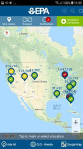
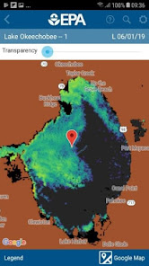
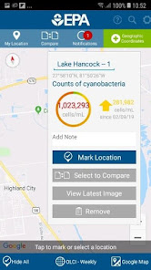
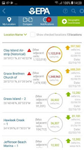
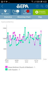
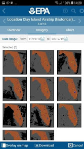
EPA's Cyanobacteria Assessment Network Application (CyAN) is a mobile app that provides users weekly satellite data to identify the concentration, location, and time series of cyanobacterial blooms in fresh and coastal waters of the United States. It is designed to inform decisions regarding recreational and drinking water safety by providing water quality managers with a user-friendly platform that reduces the complexities associated with accessing satellite data to allow fast and efficient initial assessments across water bodies. EPA scientists developed the CyAN app to help support local and state water quality managers make faster and better-informed management decisions during blooms.
Updated on
Safety starts with understanding how developers collect and share your data. Data privacy and security practices may vary based on your use, region, and age. The developer provided this information and may update it over time.

No data shared with third parties
Learn more about how developers declare sharing

No data collected
Learn more about how developers declare collection
Ratings and reviews
4.0
11 reviews

A Google user
- Flag inappropriate
August 13, 2019
This is a very well made and designed app and it is genuinely useful for the target demographic (ie, those who understand what cyanobacteria is). While it doesn't have updated numbers for every lake ever (and some smaller lakes will have none at all), it is working with the limitations of the hardware collecting the data and is pushing out updated data quickly and orderly. If you are curious about recent data for larger lakes or any data from lots of bodies of water, this app is worth a try.
12 people found this review helpful

Kelsey Jacobs
- Flag inappropriate
July 1, 2020
I work in local public health and for 3 years now, we've been dealing with cyanobacteria and no budget for monitoring, testing, etc. With this app in 2019, we matched it against our sample results and they correlated quite nicely after adjusting for the fact that the satellite images only refresh once a week ( several days before our samples and bodies of water are not static). I've recommended it to the public for use when they've asked about various bodies of water in our county.
17 people found this review helpful
A Google user
- Flag inappropriate
October 4, 2019
This App is a very powerful way to monitor and communicate Harmful Algae Booms. Friends of Lake Cascade uses the information to establish water monitoring locations, track booms on a 47 sq mile lake and report the results to local water quality managers and inform the community.
11 people found this review helpful
What's new
Updated to support newer Android devices.


