
Elm-Lappwald Mountainbike
100+
Downloads

USK: All ages
info


About this app
Many will certainly ask the question: "Is the Elm Lappwald Nature Park suitable for mountain biking"? The answer to this question is clearly “Yes!”. This wonderful hilly landscape, framed by the heath in the north and the Harz in the south, is ideal for a variety of mountain bike tours with its variety of cultural assets and sights as well as challenging trails and natural paths.
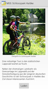
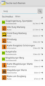
This app contains 12 suggestions for mountain bike tours in the Elm and 3 suggestions for tours in the Lappwald, which were worked out by a connoisseur together with friends. All suggestions are designed as a circular route and networked with one another in such a way that they can be individually extended or shortened if necessary. They are supplemented by information as well as contact addresses, opening times, etc. on over 90 sights and places to stop off (POIs).
We wish you a lot of fun with your activities, good weather, lots of positive impressions and hope that you will come again!
Function description:
After installing the app, the map data (approx. 80 MB) will be loaded. If your smartphone is connected to a WLAN, this happens automatically. The data can also be downloaded using a cellular connection. To do this, tap the pop-up window to confirm. Please note that this is done at the expense of your data volume.
So that your current position is shown on the map, please confirm that the app has access to your device location. You can now use the app "offline". This means that an internet connection is no longer required. Exceptions: An online connection must be established to access external Internet sites, e-mail and telephone calls.
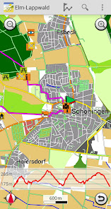
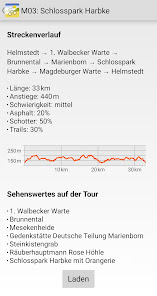
A detailed description of the tours with lots of information such as length, altitude difference, degree of difficulty and the route with information on POIs (places of interest) can be called up. There are tips and recommendations for each POI. If a suitable tour is found, it can be called up and the starting point appears immediately on the map. Your current position is constantly displayed and updated.
How far it is to the destination is shown by the remaining kilometers at the top of the screen. If you leave the route by turning the wrong way, for example, you will hear a warning tone. Arriving at your destination safely and relaxed is no problem.
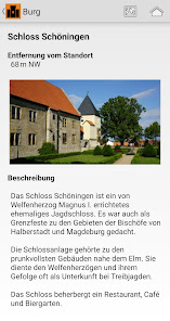
Long press on a POI symbol on the map to call up detailed information. These usually consist of a picture, a detailed description, tips and hints, as well as address, telephone number and link to the website, if available. A call can be made with one click or the website can be called up directly, which then provides current and further information.
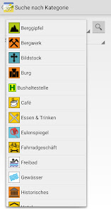
In order to keep the map clear, content can be thinned out and the display of the POIs can be individually adjusted in the settings. Depending on the focus or application, you can determine what is displayed.
You can find more information on operation in the "Help" menu.
This app contains 12 suggestions for mountain bike tours in the Elm and 3 suggestions for tours in the Lappwald, which were worked out by a connoisseur together with friends. All suggestions are designed as a circular route and networked with one another in such a way that they can be individually extended or shortened if necessary. They are supplemented by information as well as contact addresses, opening times, etc. on over 90 sights and places to stop off (POIs).
We wish you a lot of fun with your activities, good weather, lots of positive impressions and hope that you will come again!
Function description:
After installing the app, the map data (approx. 80 MB) will be loaded. If your smartphone is connected to a WLAN, this happens automatically. The data can also be downloaded using a cellular connection. To do this, tap the pop-up window to confirm. Please note that this is done at the expense of your data volume.
So that your current position is shown on the map, please confirm that the app has access to your device location. You can now use the app "offline". This means that an internet connection is no longer required. Exceptions: An online connection must be established to access external Internet sites, e-mail and telephone calls.
A detailed description of the tours with lots of information such as length, altitude difference, degree of difficulty and the route with information on POIs (places of interest) can be called up. There are tips and recommendations for each POI. If a suitable tour is found, it can be called up and the starting point appears immediately on the map. Your current position is constantly displayed and updated.
How far it is to the destination is shown by the remaining kilometers at the top of the screen. If you leave the route by turning the wrong way, for example, you will hear a warning tone. Arriving at your destination safely and relaxed is no problem.
Long press on a POI symbol on the map to call up detailed information. These usually consist of a picture, a detailed description, tips and hints, as well as address, telephone number and link to the website, if available. A call can be made with one click or the website can be called up directly, which then provides current and further information.
In order to keep the map clear, content can be thinned out and the display of the POIs can be individually adjusted in the settings. Depending on the focus or application, you can determine what is displayed.
You can find more information on operation in the "Help" menu.
Updated on
Safety starts with understanding how developers collect and share your data. Data privacy and security practices may vary based on your use, region, and age. The developer provided this information and may update it over time.

No data shared with third parties
Learn more about how developers declare sharing

No data collected
Learn more about how developers declare collection

Data isn’t encrypted
What's new
Anpassungen für Android 14
App support
About the developer
FootMap GmbH
info@footmap.de
Dingworthstr. 25-27
31137 Hildesheim
Germany
+49 1525 5187090


