Radweg Berlin-Hameln
100+
Downloads

USK: All ages
info


About this app
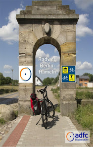
The Berlin-Hameln Cycle Route (RBH) is one of the few long-distance cycle routes that cross Germany in a west-east direction. Looking at the landscape and enjoying cycling determine the route. On almost all of the well passable paths you cycle - away from car traffic - through mountain and river landscapes, crossing the fertile bordering landscapes, the wooded regions of Fläming and the lake district of the lower Havel.
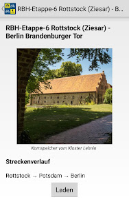
The route in the app is divided into 6 stages with lengths of 49 - 98 kilometers and a suggestion for a 6-day tour. Along the route you will receive information as well as contact addresses, opening times, etc. on sights, places to stop for refreshments and places to stay overnight.
Function description:
After installing the app, the map data (approx. 50 MB) will be loaded. If your smartphone is connected to a WLAN, this happens automatically. The data can also be downloaded using a cellular connection. To do this, tap the pop-up window to confirm. Please note that this is done at the expense of your data volume.
So that your current position is shown on the map, please confirm that the app has access to your device location. You can now use the app "offline". This means that an internet connection is no longer required. Exceptions: An online connection must be established to access external Internet sites, e-mail and telephone calls.
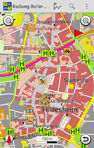
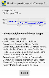
A detailed description of the tours with lots of information such as length, altitude difference, degree of difficulty and the route with information on POIs (places of interest) can be called up. There are tips and recommendations for each POI. If a suitable tour is found, it can be called up and the starting point appears immediately on the map. Your current position is constantly displayed and updated.
How far it is to the destination is shown by the remaining kilometers at the top of the screen. If you leave the route by turning the wrong way, for example, you will hear a warning tone. Arriving at your destination safely and relaxed is no problem.
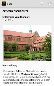
Long press on a POI symbol on the map to call up detailed information. These usually consist of a picture, a detailed description, tips and hints, as well as address, telephone number and link to the website, if available. A call can be made with one click or the website can be called up directly, which then provides current and further information.
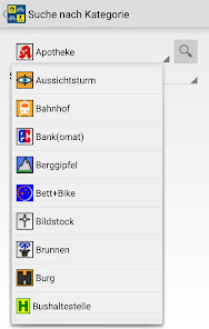
In order to keep the map clear, content can be thinned out and the display of the POIs can be individually adjusted in the settings. Depending on the focus or application, you can determine what is displayed.
You can find more information on operation in the "Help" menu.
The route in the app is divided into 6 stages with lengths of 49 - 98 kilometers and a suggestion for a 6-day tour. Along the route you will receive information as well as contact addresses, opening times, etc. on sights, places to stop for refreshments and places to stay overnight.
Function description:
After installing the app, the map data (approx. 50 MB) will be loaded. If your smartphone is connected to a WLAN, this happens automatically. The data can also be downloaded using a cellular connection. To do this, tap the pop-up window to confirm. Please note that this is done at the expense of your data volume.
So that your current position is shown on the map, please confirm that the app has access to your device location. You can now use the app "offline". This means that an internet connection is no longer required. Exceptions: An online connection must be established to access external Internet sites, e-mail and telephone calls.
A detailed description of the tours with lots of information such as length, altitude difference, degree of difficulty and the route with information on POIs (places of interest) can be called up. There are tips and recommendations for each POI. If a suitable tour is found, it can be called up and the starting point appears immediately on the map. Your current position is constantly displayed and updated.
How far it is to the destination is shown by the remaining kilometers at the top of the screen. If you leave the route by turning the wrong way, for example, you will hear a warning tone. Arriving at your destination safely and relaxed is no problem.
Long press on a POI symbol on the map to call up detailed information. These usually consist of a picture, a detailed description, tips and hints, as well as address, telephone number and link to the website, if available. A call can be made with one click or the website can be called up directly, which then provides current and further information.
In order to keep the map clear, content can be thinned out and the display of the POIs can be individually adjusted in the settings. Depending on the focus or application, you can determine what is displayed.
You can find more information on operation in the "Help" menu.
Updated on
Safety starts with understanding how developers collect and share your data. Data privacy and security practices may vary based on your use, region, and age. The developer provided this information and may update it over time.

No data shared with third parties
Learn more about how developers declare sharing

No data collected
Learn more about how developers declare collection

Data isn’t encrypted
What's new
Anpassungen für Android 14
App support
About the developer
FootMap GmbH
info@footmap.de
Dingworthstr. 25-27
31137 Hildesheim
Germany
+49 1525 5187090


