3.8star
674 reviews
Government
info
100K+
Downloads

Everyone
info


About this app
Get your California traffic information directly from the source. The Caltrans QuickMap app displays a map of your location along with real-time traffic information including:
Freeway speed
Traffic camera snapshots
Lane closures
CHP incidents
Changeable message signs
Chain controls
Snow Plows
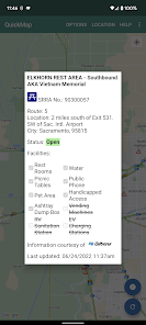
Safety Roadside Rest Areas
Border Wait Times
Park & Ride Lots
Truck Weigh Stations
Truck Escape Ramps
STAA Truck TA/SA Ramps
California Truck Networks
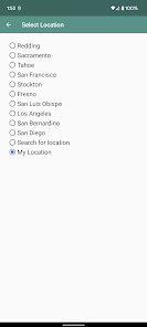
Set which of these options to display and QuickMap will remember your preferences. Zoom to a view of other parts of California with the Location button. Click on traffic camera icons to see a camera image. Click on a CHP, lane closure, changeable message sign or chain control icon to view details for that marker.
Traffic data is updated every few minutes. Load the latest data on the map using the Refresh button.
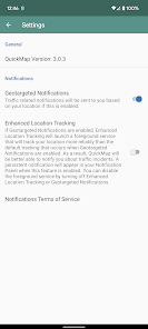
If you choose to enable Geotargeted Notifications, this app will monitor your location in the background and alert you (via a Push Notification) to State Highway System road closures occurring near you. Continued use of background location may decrease battery life.
Something not right with the data displayed on the map? Please send us an email to quickmap@dot.ca.gov rather that letting us know with a low-rated review.
Freeway speed
Traffic camera snapshots
Lane closures
CHP incidents
Changeable message signs
Chain controls
Snow Plows
Safety Roadside Rest Areas
Border Wait Times
Park & Ride Lots
Truck Weigh Stations
Truck Escape Ramps
STAA Truck TA/SA Ramps
California Truck Networks
Set which of these options to display and QuickMap will remember your preferences. Zoom to a view of other parts of California with the Location button. Click on traffic camera icons to see a camera image. Click on a CHP, lane closure, changeable message sign or chain control icon to view details for that marker.
Traffic data is updated every few minutes. Load the latest data on the map using the Refresh button.
If you choose to enable Geotargeted Notifications, this app will monitor your location in the background and alert you (via a Push Notification) to State Highway System road closures occurring near you. Continued use of background location may decrease battery life.
Something not right with the data displayed on the map? Please send us an email to quickmap@dot.ca.gov rather that letting us know with a low-rated review.
Updated on
Safety starts with understanding how developers collect and share your data. Data privacy and security practices may vary based on your use, region, and age. The developer provided this information and may update it over time.


Ratings and reviews
3.8
638 reviews

metal melisssa
- Flag inappropriate
April 1, 2025
It would be nice to have a search function. The highways are in a light yellow and barely able to be seen on the map. Not user friendly for people with low vision. I can't change it to satellite view in the app (but can on the website). Would be nice to select a route from point A to point B. Not updated in real time at all. Lags of hours to days on updates, and sometimes the information is conflicting.
9 people found this review helpful

Jorge Aleman
- Flag inappropriate
June 19, 2025
I have used this app when we take trips outside of our area and it's very helpful. I did notice that the map was not showing for some time. I "force stop" the app, clear the stored & cache files, re-applied the permissions and check the options that I want to see on the app. All of that brought back the map.
4 people found this review helpful

Lawrence OShane
- Flag inappropriate
January 16, 2026
I love this app. I wish the other states that have apps would use this as a template. it's a big help and it helps me with my trip planning because I'm a truck driver and that's very important. occasionally the information is old or not correct but it doesn't happen often. I wish the camera thing would work better. A lot of times the cameras don't work.
What’s new
Added Overweight Corridor and Caltrans District Boundary layers
App support
About the developer
California, Department Of Transportation
caltrans.developer@dot.ca.gov
1120 N St
Sacramento, CA 95814
United States
+1 916-217-0536


