Locus GIS offline land survey
In-App-Käufe
3.9star
1.47 Tsg. Rezensionen
500 Tsg.+
Downloads

Jedes Alter
info


Über diese App
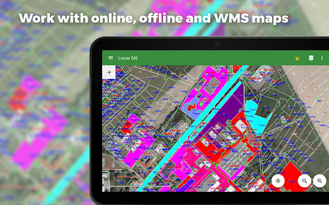
Professional GIS application for offline fieldwork with geodata. It provides data collection, viewing, and updating. All its features are available above a wide selection of online, offline, and WMS maps.
Fieldwork
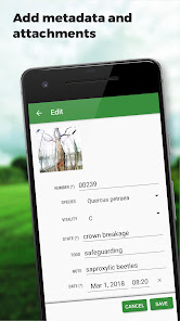
• offline collecting and updating of field data
• saving points with current or arbitrary position
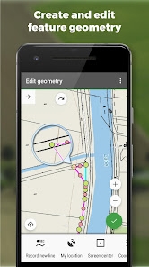
• creating lines and polygons by motion recording
• settings of attributes
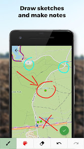
• photos, video/audio or drawings as attachments
• guidance to points
• collecting location data for polygon/line recording or guidance on a target, even when the app is running in the background
Import/Export
• importing and editing ESRI SHP files
• exporting data to ESRI SHP or CSV files
• exporting whole projects to QGIS
Maps
• wide range of maps both for online use and for download
• support of WMS sources
• support of offline maps in MBTiles, SQLite, MapsForge, TAR, GEMF, RMAP formats, and custom OpenStreetMap data or map themes
Tools and features
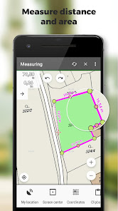
• measuring distances and areas
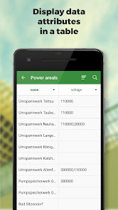
• searching and filtering of data in the attribute table
• style editing and text labels
• organizing data into layers and projects
Locus GIS is successfully used in a wide range of industries:
• collection of environmental data (ecological scanning, tree surveys ...)
• forestry management and planning,
• agriculture and soil management
• gas and energy distribution
• planning and construction of wind farms
• exploration of mining fields and location of wells
• survey and management of urban facilities
• road constructions and maintenance
Fieldwork
• offline collecting and updating of field data
• saving points with current or arbitrary position
• creating lines and polygons by motion recording
• settings of attributes
• photos, video/audio or drawings as attachments
• guidance to points
• collecting location data for polygon/line recording or guidance on a target, even when the app is running in the background
Import/Export
• importing and editing ESRI SHP files
• exporting data to ESRI SHP or CSV files
• exporting whole projects to QGIS
Maps
• wide range of maps both for online use and for download
• support of WMS sources
• support of offline maps in MBTiles, SQLite, MapsForge, TAR, GEMF, RMAP formats, and custom OpenStreetMap data or map themes
Tools and features
• measuring distances and areas
• searching and filtering of data in the attribute table
• style editing and text labels
• organizing data into layers and projects
Locus GIS is successfully used in a wide range of industries:
• collection of environmental data (ecological scanning, tree surveys ...)
• forestry management and planning,
• agriculture and soil management
• gas and energy distribution
• planning and construction of wind farms
• exploration of mining fields and location of wells
• survey and management of urban facilities
• road constructions and maintenance
Aktualisiert am
Was die Sicherheit angeht, solltest du nachvollziehen, wie Entwickler deine Daten erheben und weitergeben. Die Datenschutz- und Sicherheitspraktiken können je nach Verwendung, Region und Alter des Nutzers variieren. Diese Informationen wurden vom Entwickler zur Verfügung gestellt und können jederzeit von ihm geändert werden.

Keine Daten werden mit Drittunternehmen oder -organisationen geteilt

Diese App kann die folgenden Datentypen erheben
Personenbezogene Daten, Finanzdaten und 2 andere

Daten werden bei der Übertragung verschlüsselt

Du kannst das Löschen der Daten beantragen
Bewertungen und Rezensionen
3.9
1.39 Tsg. Rezensionen
Neuigkeiten
*** 1.22.2 ***
- add: a brand-new manager for GNSS external devices
- add: NTRIP client (currently in beta testing)
- add: ability to choose multiple options for enumeration attributes
- add: a completely new system for managing accuracy tolerances and warnings
- add: edit the starting number in the auto-numbering sequence
- add: option to add several independent WMS layers from a single WMS service


