
Locus Map Outdoor Navigation
Contains adsIn-app purchases

4.3star
64.2K reviews

Everyone
info
5M+
Downloads


About this app
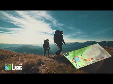
Discover the joy of exploring the great outdoors with Locus Map, your ultimate navigation app designed for a seamless and enjoyable outdoor experience. Whether you're hiking through serene trails, biking across rugged terrains, or embarking on any adventure under the sun, Locus Map is here to guide you every step of the way.
• Begin Your Story with a Map:
Your adventure starts with the perfect map. Choose from an extensive selection of offline maps for anywhere in the world. From the lush trails for hiking and biking to the snow-covered paths for cross-country skiing, Locus Map has got you covered. Dive into the world of LoMaps with detailed points of interest, offline addresses, and a variety of map themes – hiking, biking, winter, or city. Begin your journey with 3 FREE map downloads and set the stage for your adventure.
• Craft Your Perfect Route:
Plan and tailor your routes with precision, whether you're tracing along marked trails or forging your own path in open terrain. Utilize our web or app-based planners to sketch out your adventure, ensuring every turn, ascent, and descent is captured. Import and export routes in multiple formats, making it easy to share your plans or bring others' experiences to life on your journey.
• Connect and Monitor:
Elevate your outdoor activities by connecting with BT/ANT+ sensors. Monitor your performance with detailed statistics like distance, speed, pace, and calories burned. Let Locus Map be your digital companion, tracking your progress and guiding you with turn-by-turn voice instructions or simple sound alerts. Stay on course with out-of-route alerts and off-trail guidance, ensuring you're always headed in the right direction. Plus, with Android Auto support, get clear navigation guidance right on your car display — perfect for reaching the trailhead or navigating between outdoor destinations.
• Record and Relive:
Capture every moment of your journey with track recording. Watch your adventure unfold on the map, complete with all the stats that matter to you. Create a personal database of your favorite spots and geotagged photos, making every outing a story worth telling.
• Share Your Journey:
Bring your adventures to life by sharing your tracks with friends, family, or fellow explorers on platforms like Strava, Runkeeper, or Google Earth. Whether it's a challenging hike, a scenic bike ride, or a collection of geocaching treasures, share the excitement and inspire others to explore.
• Geocaching and Beyond:
For the treasure hunters at heart, Locus Map offers specialized geocaching tools. Download caches for offline play, navigate with precision, and manage your finds with ease. It's geocaching made simple, fun, and rewarding.
• Customize Your Experience:
Locus Map is as unique as your adventure. Customize the app to fit your needs, from the main menu to screen panels, control settings, and more. Switch between light and dark modes, select your preferred units and dashboard, and configure presets for a smooth, multifunctional app experience.
• Unlock the Full Adventure with Premium:
Go beyond the basics with Locus Map Premium. Enjoy the full suite of offline maps, navigate without limits with the offline router, and sync your explorations across devices. Plan on a big screen with web integration, share your location in real-time, take your navigation to the car with Android Auto integration, and leverage the full power of map tools and sport packet features.
Your journey awaits. Download Locus Map today, and turn every outing into an unforgettable adventure. Let's explore the world together, one step, pedal, or ski at a time.
Note: The automatic display activation feature for navigation requires system permission to use accessibility services.
Updated on
Safety starts with understanding how developers collect and share your data. Data privacy and security practices may vary based on your use, region, and age. The developer provided this information and may update it over time.

No data shared with third parties
Learn more about how developers declare sharing

This app may collect these data types
Location, Personal info and 7 others

Data is encrypted in transit

You can request that data be deleted
Ratings and reviews
4.3
60.8K reviews

Matt Sorensen
- Flag inappropriate
July 6, 2021
I've been using Pro for years and just switched to Locus Maps 4 Gold Subscription. The price is definitely a little high, but I'm impressed so far and I do like to support outdoors app development. The website is nice. Synchronization of tracks is great. I'm still trying to figure out the offline LoRouter. It does seem to work offline, but I'm not sure what areas I have downloaded. That part is a little confusing.
61 people found this review helpful

A Google user
- Flag inappropriate
June 9, 2019
Very full-featured navigation and map software that has a lot of options even in the free version. I was primarily interested in the track recording ability of this app. There it is a little disappointing. It is able to record tracks, and you can set up different profiles for different activities so that you get accurate tracks. Lots of stats on the tracks recorded. But the UI is unnecessarily complicated, and you can only add way points as the track is being recorded, not add way points to an existing track. There is also no ability to find details of specific points on the track (distance from beginning or end, time visited, coordinates, etc.)
58 people found this review helpful

Jolie M.
- Flag inappropriate
December 22, 2023
Ive been trying to use this app to navigate between two GPS points without success, for a long time! It regularly prompts me to download additional data to be able to use the navigation feature, of course agreeing to download said data changes nothing, the prompt reappears each time. I have not once successfully used it. This should be so much simpler and easier!
20 people found this review helpful
Asamm Software, s. r. o.
December 25, 2023
Hi, we are sorry for any inconvenience. Please, contact our support team at https://help.locusmap.eu/ticket/add and send a detailed description of the problem, including screenshots. We'll do our best to help. Michal, Locus team
What’s new
*** Locus Map 4.34 ***
- chg: reworked "Places and addresses" search screen
- chg: integrated Augmented reality add-on, reworked widget, improvements in charts, ...
- and a lot more
- chg: reworked "Places and addresses" search screen
- chg: integrated Augmented reality add-on, reworked widget, improvements in charts, ...
- and a lot more
App support
About the developer
Asamm Software, s.r.o.
locus.map@asamm.com
3129/8 K odpočinku
193 00 Praha
Czechia
+420 775 751 246


