

OsmAnd+ — Maps & GPS Offline
In-app purchases

4.5star
39.3K reviews
100K+
Downloads

Everyone
info


About this app
OsmAnd+ is an offline world map application based on OpenStreetMap (OSM), which allows you to navigate taking into account the preferred roads and vehicle dimensions. Plan routes based on inclines and record GPX tracks without an internet connection.
OsmAnd+ is an open source app. We do not collect user data and you decide what data the app will have access to.
Main features:
OsmAnd+ privileges (Maps+)
• Android Auto support;
• Unlimited map downloads;
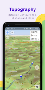
• Topo data (Contour lines and Terrain);
• Nautical depths;
• Offline Wikipedia;
• Offline Wikivoyage - Travel guides;
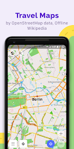
Map view
• Choice of places to be displayed on the map: attractions, food, health and more;
• Search for places by address, name, coordinates, or category;
• Map styles for the convenience of different activities: touring view, nautical map, winter and ski, topographic, desert, off-road, and others;
• Shading relief and plug-in contour lines;
• Ability to overlay different sources of maps on top of each other;
GPS Navigation
• Plotting a route to a place without an Internet connection;
• Customizable navigation profiles for different vehicles: cars, motorcycles, bicycles, 4x4, pedestrians, boats, public transport, and more;
• Change the constructed route, taking into account the exclusion of certain roads or road surfaces;
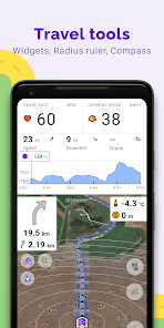
• Customizable information widgets about the route: distance, speed, remaining travel time, distance to turn, and more;
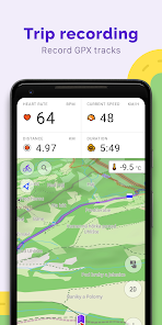
Route Planning and Recording
• Plotting a route point by point using one or multiple navigation profiles;
• Route recording using GPX tracks;
• Manage GPX tracks: displaying your own or imported GPX tracks on the map, navigating through them;
• Visual data about the route - descents/ascents, distances;
• Ability to share GPX track in OpenStreetMap;
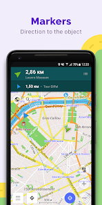
Creation of points with different functionality
• Favourites;
• Markers;
• Audio/video notes;
OpenStreetMap
• Making edits to OSM;
• Updating maps with a frequency of up to one hour;
Additional features
• Compass and radius ruler;
• Mapillary interface;
• Nautical depths;
• Offline Wikipedia;
• Offline Wikivoyage - Travel guides;
• Night theme;
• Large community of users around the world, documentation, and support;
Paid features:
OsmAnd Pro (subscription)
• OsmAnd Cloud (backup and restore);
• Cross-platform;
• Hourly map updates;
• Weather plugin;
• Elevation widget;
• Customise route line;
• External sensors support (ANT+, Bluetooth);
• Online Elevation profile.
OsmAnd+ is an open source app. We do not collect user data and you decide what data the app will have access to.
Main features:
OsmAnd+ privileges (Maps+)
• Android Auto support;
• Unlimited map downloads;
• Topo data (Contour lines and Terrain);
• Nautical depths;
• Offline Wikipedia;
• Offline Wikivoyage - Travel guides;
Map view
• Choice of places to be displayed on the map: attractions, food, health and more;
• Search for places by address, name, coordinates, or category;
• Map styles for the convenience of different activities: touring view, nautical map, winter and ski, topographic, desert, off-road, and others;
• Shading relief and plug-in contour lines;
• Ability to overlay different sources of maps on top of each other;
GPS Navigation
• Plotting a route to a place without an Internet connection;
• Customizable navigation profiles for different vehicles: cars, motorcycles, bicycles, 4x4, pedestrians, boats, public transport, and more;
• Change the constructed route, taking into account the exclusion of certain roads or road surfaces;
• Customizable information widgets about the route: distance, speed, remaining travel time, distance to turn, and more;
Route Planning and Recording
• Plotting a route point by point using one or multiple navigation profiles;
• Route recording using GPX tracks;
• Manage GPX tracks: displaying your own or imported GPX tracks on the map, navigating through them;
• Visual data about the route - descents/ascents, distances;
• Ability to share GPX track in OpenStreetMap;
Creation of points with different functionality
• Favourites;
• Markers;
• Audio/video notes;
OpenStreetMap
• Making edits to OSM;
• Updating maps with a frequency of up to one hour;
Additional features
• Compass and radius ruler;
• Mapillary interface;
• Nautical depths;
• Offline Wikipedia;
• Offline Wikivoyage - Travel guides;
• Night theme;
• Large community of users around the world, documentation, and support;
Paid features:
OsmAnd Pro (subscription)
• OsmAnd Cloud (backup and restore);
• Cross-platform;
• Hourly map updates;
• Weather plugin;
• Elevation widget;
• Customise route line;
• External sensors support (ANT+, Bluetooth);
• Online Elevation profile.
Updated on
Safety starts with understanding how developers collect and share your data. Data privacy and security practices may vary based on your use, region, and age. The developer provided this information and may update it over time.

No data shared with third parties
Learn more about how developers declare sharing

This app may collect these data types
Personal info, Photos and videos and 5 others

Data is encrypted in transit

You can request that data be deleted
Ratings and reviews
4.5
34.8K reviews

David Lee
- Flag inappropriate
July 11, 2024
Definitely an alternative to google map. Especially of late, there are too many things that google map is trying to do in the back ground, but it's hard not to use google map since it's integrated into many other apps. EDIT: As of the latest update, I have to say, this map app is a definite challenger to the map app that's in every navigation search results, the Google map.
5 people found this review helpful

Jimi “Wolfi” Wolfgang
- Flag inappropriate
July 22, 2024
I was willing to overlook the bloated interface with endless settings within settings, the fact that address lookup has literally never worked, the busy display, the clunky controls, and the insane amount of fiddling needed to do some of the most basic things, but recently it completely stopped being able to work offline, even to the end of my street! Settings didn't fix it, deleting and reinstalling didn't, now I'm stuck using the free version so I can route offline. Wish I could just fire them
OsmAnd
July 22, 2024
Hello! Thank you for the feedback.
Please check that Navigation type is set to Offline in Menu – Settings – Profile – Navigation settings. If it doesn't help, please contact us at support@osmand.net

Matt Roberts
- Flag inappropriate
June 11, 2023
This is a cleaner app than Google Maps -- less clutter on the screen and a more intuitive interface. It also runs much faster than Maps on the same hardware. I like the ability to download maps state-by-state as I need them. My only complaint is that it asks about once a week for me to upgrade to a subscription, when I have already paid for the "plus" app. I click the "X" and it stops asking for a few more days.
54 people found this review helpful
What's new
• New terrain colorization option "Altitude"
• Custom color palettes for terrain, tracks, and routes
• 3D variant for location position icons
• Quick Actions can now be assigned to external keyboards
• Weather: UI refresh, added wind animation
• 3D Track Improvements: new visualization and colorization options
• Expanded selection of tourist routes on the map
• Added app theme option to follow map mode
• Fixed track stats, sorting & search


