Waterkaarten: Boat Navigation
In-app purchases
4.2star
2.53K reviews
100K+
Downloads

Everyone
info


About this app
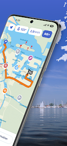
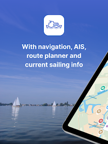
The most comprehensive app for safe and prepared boating navigation. With route planner, water maps, AIS pairing, marinas, bridges and locks, offline use and more. Try now and plan your next trip!
With the Waterkaarten app (formerly ANWB Waterkaarten) you have everything you need at hand:
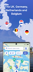
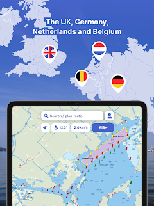
• 5 countries, 1 price: Complete nautical maps of the United Kingdom, Netherlands, Germany, France and Belgium
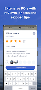
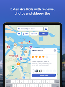
• All almanack info: Access all information you need on the water with just a few taps in the app
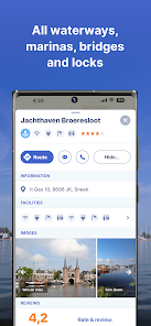
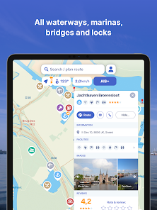
• All current information about marinas, bridges and locks including opening times
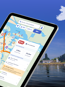
• Plan the optimal route between your starting point and destination, including the objects you encounter
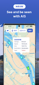
• New! AIS pairing: Connect your AIS device to the app and see at a glance where surrounding ships are located
• Show or hide information on the nautical maps to see exactly what you need
• Stay up-to-date with the current navigation reports and obstructions from the Rijkswaterstaat
• More than 200,000 nautical objects (bridges, locks, markings, mooring places and more)
• Locations of more than 4,000 marinas and all details of existing facilities
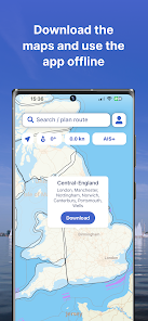
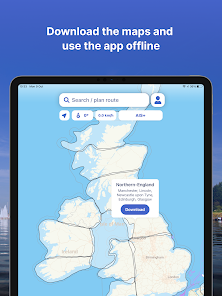
• Radio silence on the water? No problem! Download the corresponding charts for offline use
• Regular updates and free access to all new features
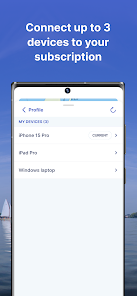
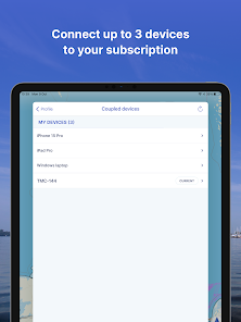
• Each user account can be used on up to 3 devices at no extra cost
• Free Windows version included
• Reliable service: We are at your service 7 days a week (support@waterkaarten.app)
How it works:
Waterkaarten is free for the first 7 days. After that, the app only works with a valid subscription. You can choose from the following options:
• Month (£ 11.99)
• Season (3 months for £ 29.99)
• Year (£ 44.99)
The subscription ends automatically.
Please note: If you purchase a subscription during the free 7-day trial period, we will add your new credit to your remaining balance. Your purchased subscription is not automatically renewed.
Payment methods for subscription:
• The subscription will be charged to your Google account
• At Google you can use different payment methods, such as PayPal or credit card
Even more boating pleasure with a Waterkaarten account
You can create an account in the app to activate your subscription on a total of 3 devices.
Note:
• The file size of the offline map material is very large and you are advised to download it on a stable Wi-Fi connection
• Prolonged use of GPS in the background can considerably shorten the battery life of your device
Do you have questions about the app? Please contact our helpdesk (support@waterkaarten.app) or read more on our website: www.waterkaarten.app/en.
Please note that this app is only intended as an aid when navigating on the water. Stay alert to your surroundings while boating.
With the Waterkaarten app (formerly ANWB Waterkaarten) you have everything you need at hand:
• 5 countries, 1 price: Complete nautical maps of the United Kingdom, Netherlands, Germany, France and Belgium
• All almanack info: Access all information you need on the water with just a few taps in the app
• All current information about marinas, bridges and locks including opening times
• Plan the optimal route between your starting point and destination, including the objects you encounter
• New! AIS pairing: Connect your AIS device to the app and see at a glance where surrounding ships are located
• Show or hide information on the nautical maps to see exactly what you need
• Stay up-to-date with the current navigation reports and obstructions from the Rijkswaterstaat
• More than 200,000 nautical objects (bridges, locks, markings, mooring places and more)
• Locations of more than 4,000 marinas and all details of existing facilities
• Radio silence on the water? No problem! Download the corresponding charts for offline use
• Regular updates and free access to all new features
• Each user account can be used on up to 3 devices at no extra cost
• Free Windows version included
• Reliable service: We are at your service 7 days a week (support@waterkaarten.app)
How it works:
Waterkaarten is free for the first 7 days. After that, the app only works with a valid subscription. You can choose from the following options:
• Month (£ 11.99)
• Season (3 months for £ 29.99)
• Year (£ 44.99)
The subscription ends automatically.
Please note: If you purchase a subscription during the free 7-day trial period, we will add your new credit to your remaining balance. Your purchased subscription is not automatically renewed.
Payment methods for subscription:
• The subscription will be charged to your Google account
• At Google you can use different payment methods, such as PayPal or credit card
Even more boating pleasure with a Waterkaarten account
You can create an account in the app to activate your subscription on a total of 3 devices.
Note:
• The file size of the offline map material is very large and you are advised to download it on a stable Wi-Fi connection
• Prolonged use of GPS in the background can considerably shorten the battery life of your device
Do you have questions about the app? Please contact our helpdesk (support@waterkaarten.app) or read more on our website: www.waterkaarten.app/en.
Please note that this app is only intended as an aid when navigating on the water. Stay alert to your surroundings while boating.
Updated on
Safety starts with understanding how developers collect and share your data. Data privacy and security practices may vary based on your use, region, and age. The developer provided this information and may update it over time.

No data shared with third parties
Learn more about how developers declare sharing

This app may collect these data types
Personal info, Photos and videos and 3 others

Data is encrypted in transit

You can request that data be deleted
Ratings and reviews
4.0
1.91K reviews

Nick Reynolds
- Flag inappropriate
- Show review history
September 1, 2022
The app is generally good, the auto routing feature worked well for me. I wouldn't want to navigate the Netherlands without it. There are some factual errors. One bridge height was incorrect. One new bridge was missing. One bridge was noted as closed, but was open and there was no contact information for the bridge, and no way to comment on the bridge information. Auto routing didn't recognize the closure. Routing underestimated transit times for my slow boat, we should be able to set speed
12 people found this review helpful
Biggerworks
September 2, 2022
Hey Nick, If you send us a mail on support@waterkaarten.app, we love to hear which information was wrong. We can also explain how you can report that through the app. Thousands of people do that and we update information every week.

Wim Bruns
- Flag inappropriate
- Show review history
April 17, 2024
Was hoping that this app would also include the sea between UK and Netherlands but no.

A Google user
- Flag inappropriate
- Show review history
December 11, 2018
This is a great app (probably the best one) for navigation in The Nederlands. It provides much more valuable information than the paper version of the ANWB waterkaart. For maximum benefit I recommend the use of a tablet, rather than a smartphone, because the larger screen area provides for the better overview. The most valuable feature is the indication of one's own position within the map, which is made possible by means of the location services of the tablet or smartphone. Because I travel frequently to the Nederlands for boating vacation, I decided for a yearly subscription.
25 people found this review helpful
Biggerworks
June 20, 2019
Wow. Thanks for this positive and valuable feedback. And thanks for becoming a loyal customer also ;)
What's new
!NEW! Map Layer
- France can now be downloaded
- New and improved map layer
- Updated colours / contrast
- New map items added (e.g. toilets, picnic places)
- Redesigned map items (e.g., bridges and locks)
- Better definition for water depths
- Moorings now display the names
- Various other fixes and improvements
- France can now be downloaded
- New and improved map layer
- Updated colours / contrast
- New map items added (e.g. toilets, picnic places)
- Redesigned map items (e.g., bridges and locks)
- Better definition for water depths
- Moorings now display the names
- Various other fixes and improvements


