EyeRADAR

Content rating
Everyone
50+
Downloads
Content rating
Everyone
Learn more
Screenshot image
Screenshot image
Screenshot image
Screenshot image

About this app

🛰️ EyeRadar – Monitor terrain with InSAR satellite technology with Detektia


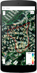
EyeRadar is the official app of Detektia, a professional tool for visualizing and monitoring ground deformation data based on InSAR (Interferometric Satellite Radar) technology.

Designed for engineers, technicians, and infrastructure managers, EyeRadar allows you to access deformation maps, analyze time series, and receive customized alerts about movements detected in critical areas.

🧠 Main Features:


✔ Visualization of deformation rate maps (mm/year)
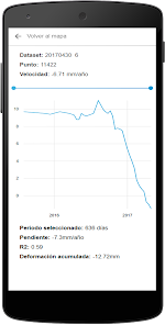
✔ Access to time series by control point
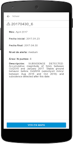
✔ Alerts for anomalous movements in key locations
✔ Comparison of satellite geometries (upward and downward)
✔ Monitoring by scenario and project
✔ Clear, fast, and accessible interface from anywhere

🌍 Applications


✔ Monitoring of unstable slopes and hillsides
✔ Monitoring of linear infrastructure (roads, railways, canals)
✔ Monitoring of urban or industrial subsidence
✔ Monitoring of underground works or tunnels

🔒 Privacy and Security


EyeRadar is linked to authorized Detektia accounts. To access the data, you must log in with valid credentials.
Updated on
Jun 25, 2026

Data safety

Safety starts with understanding how developers collect and share your data. Data privacy and security practices may vary based on your use, region, and age. The developer provided this information and may update it over time.
No data shared with third parties
Learn more about how developers declare sharing
No data collected
Learn more about how developers declare collection

What’s new

Detektia EyeRADAR Android APP
Content rating
Everyone
Learn more

App support

About the developer
DETEKTIA EARTH SURFACE MONITORING SL.
csancho@detektia.com
CALLE GUADALAJARA, 1 - 1 C 42004 SORIA Spain
+34 644 08 13 32