Hurricane & Typhoon Track
Enthält Werbung
3.7star
518 Rezensionen
100 Tsg.+
Downloads

Jedes Alter
info


Über diese App
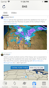
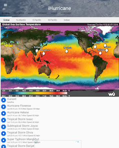
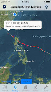
Hurricane & Typhoon Track allows you to keep track of tropical storm ,Typhoon,and hurricane activity in the Global Ocean basins. gives you the most up to the minute and reliable hurricane & Typhoon path,Tracking Map,coordinates data,Satellite Images, Computer Models,Warning Information and high resolution Satellite maps... with data provided by 22,000+ trusted or official weather stations all over the world.
Also, you will be able to stay informed on the status of the local and national power grid and surge probability.
Here are the key highlights of this application...
* Quick overview of active hurricanes, tropical storms, depressions, and other cyclones
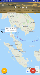
* Get real-time Hurricane & Typhoon Tracking
* Emergency Shelters
* Tap on any map to view full screen, with pinch-to-zoom, drag, and scroll support, even during loop playback
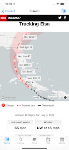
* Current Storm Location
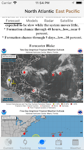
* Computer Models
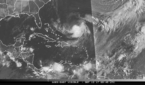
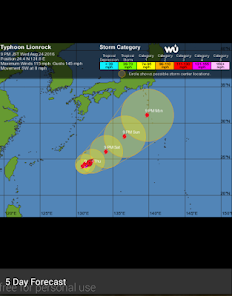
* Forecast cones (5-day uncertainty track), wind speed probability, storm surge maps (when available), and GOES Floater satellite imagery
* Storm Surge Probability
* Optional Forecast Model Viewer Add-On: View forecast models (also known as spag models) for active systems on an interactive map complete with panning, zooming, and individual model point information when tapped. Features selectable models, start time, and run length
* Sharing of screenshots with any app that supports it (Facebook, Twitter, etc.)
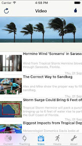
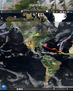
* Multiple types of regional summary maps and satellite loops to choose from (full list below)
* Road Maps
* Historical Map
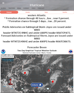
* Per-storm advisory & discussion text from the experts at the National Hurricane Center, Public & Marin Advisory
**************************************
all the data is just from National Oceanic and Atmospheric Administration, (NOAA)
Stay informed about the latest tropical systems in the Atlantic,Pacific,Indian Ocean and Caribbean . Get the most recent maps and forecast details about active storms.
Also, you will be able to stay informed on the status of the local and national power grid and surge probability.
Here are the key highlights of this application...
* Quick overview of active hurricanes, tropical storms, depressions, and other cyclones
* Get real-time Hurricane & Typhoon Tracking
* Emergency Shelters
* Tap on any map to view full screen, with pinch-to-zoom, drag, and scroll support, even during loop playback
* Current Storm Location
* Computer Models
* Forecast cones (5-day uncertainty track), wind speed probability, storm surge maps (when available), and GOES Floater satellite imagery
* Storm Surge Probability
* Optional Forecast Model Viewer Add-On: View forecast models (also known as spag models) for active systems on an interactive map complete with panning, zooming, and individual model point information when tapped. Features selectable models, start time, and run length
* Sharing of screenshots with any app that supports it (Facebook, Twitter, etc.)
* Multiple types of regional summary maps and satellite loops to choose from (full list below)
* Road Maps
* Historical Map
* Per-storm advisory & discussion text from the experts at the National Hurricane Center, Public & Marin Advisory
**************************************
all the data is just from National Oceanic and Atmospheric Administration, (NOAA)
Stay informed about the latest tropical systems in the Atlantic,Pacific,Indian Ocean and Caribbean . Get the most recent maps and forecast details about active storms.
Aktualisiert am
Was die Sicherheit angeht, solltest du als Erstes verstehen, wie Entwickler deine Daten erheben und weitergeben. Die Datenschutz- und Sicherheitspraktiken können je nach deiner Verwendung, deiner Region und deinem Alter variieren. Diese Informationen wurden vom Entwickler zur Verfügung gestellt und können jederzeit von ihm geändert werden.

Diese App kann die folgenden Datentypen an Dritte weitergeben
Standort und Geräte- oder andere IDs

Keine Daten erhoben

Daten werden bei der Übertragung verschlüsselt

Daten können nicht gelöscht werden
Bewertungen und Rezensionen
3.7
495 Rezensionen
Neuerungen
bug fix
Support für diese App
Informationen zum Entwickler
胡勇
yystudio4000@gmail.com
China
undefined


