Citymapper
Contains adsIn-app purchases
4.9star
358K reviewsinfo
10M+
Downloads

PEGI 3
info


About this app
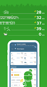
Instantly compare your travel options in real-time across all transport modes!
Easily navigate your city with turn-by-turn directions for all your public transportation, walking, cycling and scooter trips.
Find the best route
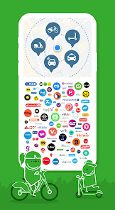
► Simple city navigation and trip planning combining bus 🚎 subway 🚇 train 🚄 ferry ⛴ cabs 🚕 ride share 🚖 car share 🚗 bike share 🚲 e-scooters 🛴 and walking 🚶♂️Discover routes you never knew existed 🕵️♀️!
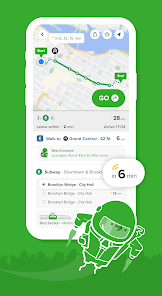
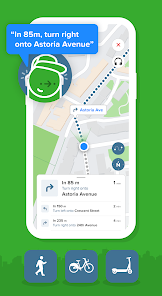
Hit the GO button for step-by-step directions
► Turn-by-turn navigation for your transit, walking, cycling and scooter trips. Choose between 3 different map views, see the charge levels of e-scooters and e-bikes around you, and avoid no-parking zones. We take care of the logistical thinking with our smart route planner so you are free to enjoy the ride 🙌
Experience one-stop-shop mobility
► Compare cab fares, hail a ride, hop on a shared bike or get on the nearest scooter. Our partners include: Uber, Lyft, JUMP, Lime, Bird, Spin, Skip, Scoot, Citi Bike, JerseryBike, Bluebikes, Indego, CaBi, Divvy, Metro Bike, Breeze, Bay Wheels, Healthy Ride, Relay, BCycle, SA Bike Share, GREENbike, Grid, RTC Bike, BIKETOWN, Biki 🚖 🚲 🛴
Beat the rush-hour crowd
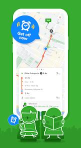
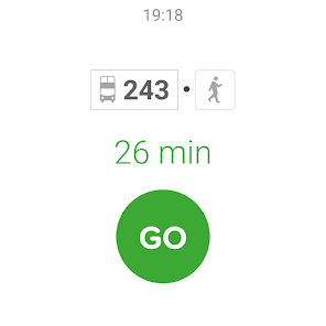
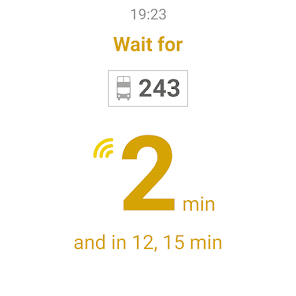
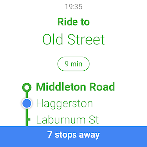
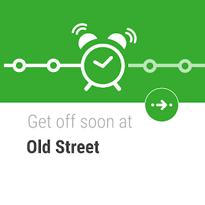
► Live wait times and ETA so you'll never miss a bus, train or ferry again. Follow your public transportation as it’s approaching on a real-time map with our train & bus tracker. See the best train car to board, check the next train or bus stop, get alerted when it's time to get off, and get in and out from the best exit at any subway / train station ⏰
Smarten up your daily transit navigation
► Get daily updates right on your lock screen for all public transportation: real-time bus arrivals, subway, ferry and train times, with disruption / delay / status alerts and alternative routes. Stay on top of any changes to your local bus schedule, train schedule or ferry timetable with the all-in-one transit tracker 🚨
Personalize your city navigation
► Save Home, Work and your go-to stops / stations for fast trip planning. Subscribe to your favorite subway, train, bus or ferry line for automatic disruption / delay / status alerts. Your local subway map, next bus time, subway time and train schedule at your fingertips ❤️
Get social
► Share your live trip: let friends follow your live trip to know when you'll arrive. Share any location or address: one tap for others to get directions 🤳
Travel offline
► Access offline the official NYC subway map, Manhattan bus transit map, Brooklyn bus map, MTA map, Queens bus map, DC metro map, Muni metro map, and more 🗺
Works on Wear OS
► Hit GO in the app and automatically see all the information you need during your trip on your Wear OS watch.
Cities
► New York City | Chicago | Los Angeles | San Francisco | Washington DC | Boston | Philadelphia | Seattle | Miami | Atlanta | Portland | Denver | Baltimore | San Diego | Minneapolis | Houston | Phoenix | Dallas | Las Vegas | Pittsburgh | Honolulu | Salt Lake City | San Antonio | St. Louis | Cleveland | Austin + Many more worldwide! See the full list and vote for the next one in the app or at https://citymapper.com/cities 🏙
Agencies
► We use open data from transit agencies, including: MTA | CTA | LA Metro | MBTA | WMATA | SEPTA | NJ Transit | Muni | BART | King Bus | MARTA | LIRR | RTD | TriMet | Metro-North Railroad | PATH | Houston METRO | San Diego MTS | Miami-Dade Transit | Metro Transit MN | METRA | RTC | TheBus | Port Authority | DART | AC Transit | Sound Transit | UTA | OCTA | VIA | PTD | St. Louis Metro Transit | RTA | Capital Metro | Broward County Transit Division | NY Waterway Ferries | LBT 📈
Keep in touch
► If you have any questions or feedback email us at: support@citymapper.com
Follow us on Twitter: /Citymapper
Visit our website: citymapper.com
Easily navigate your city with turn-by-turn directions for all your public transportation, walking, cycling and scooter trips.
Find the best route
► Simple city navigation and trip planning combining bus 🚎 subway 🚇 train 🚄 ferry ⛴ cabs 🚕 ride share 🚖 car share 🚗 bike share 🚲 e-scooters 🛴 and walking 🚶♂️Discover routes you never knew existed 🕵️♀️!
Hit the GO button for step-by-step directions
► Turn-by-turn navigation for your transit, walking, cycling and scooter trips. Choose between 3 different map views, see the charge levels of e-scooters and e-bikes around you, and avoid no-parking zones. We take care of the logistical thinking with our smart route planner so you are free to enjoy the ride 🙌
Experience one-stop-shop mobility
► Compare cab fares, hail a ride, hop on a shared bike or get on the nearest scooter. Our partners include: Uber, Lyft, JUMP, Lime, Bird, Spin, Skip, Scoot, Citi Bike, JerseryBike, Bluebikes, Indego, CaBi, Divvy, Metro Bike, Breeze, Bay Wheels, Healthy Ride, Relay, BCycle, SA Bike Share, GREENbike, Grid, RTC Bike, BIKETOWN, Biki 🚖 🚲 🛴
Beat the rush-hour crowd
► Live wait times and ETA so you'll never miss a bus, train or ferry again. Follow your public transportation as it’s approaching on a real-time map with our train & bus tracker. See the best train car to board, check the next train or bus stop, get alerted when it's time to get off, and get in and out from the best exit at any subway / train station ⏰
Smarten up your daily transit navigation
► Get daily updates right on your lock screen for all public transportation: real-time bus arrivals, subway, ferry and train times, with disruption / delay / status alerts and alternative routes. Stay on top of any changes to your local bus schedule, train schedule or ferry timetable with the all-in-one transit tracker 🚨
Personalize your city navigation
► Save Home, Work and your go-to stops / stations for fast trip planning. Subscribe to your favorite subway, train, bus or ferry line for automatic disruption / delay / status alerts. Your local subway map, next bus time, subway time and train schedule at your fingertips ❤️
Get social
► Share your live trip: let friends follow your live trip to know when you'll arrive. Share any location or address: one tap for others to get directions 🤳
Travel offline
► Access offline the official NYC subway map, Manhattan bus transit map, Brooklyn bus map, MTA map, Queens bus map, DC metro map, Muni metro map, and more 🗺
Works on Wear OS
► Hit GO in the app and automatically see all the information you need during your trip on your Wear OS watch.
Cities
► New York City | Chicago | Los Angeles | San Francisco | Washington DC | Boston | Philadelphia | Seattle | Miami | Atlanta | Portland | Denver | Baltimore | San Diego | Minneapolis | Houston | Phoenix | Dallas | Las Vegas | Pittsburgh | Honolulu | Salt Lake City | San Antonio | St. Louis | Cleveland | Austin + Many more worldwide! See the full list and vote for the next one in the app or at https://citymapper.com/cities 🏙
Agencies
► We use open data from transit agencies, including: MTA | CTA | LA Metro | MBTA | WMATA | SEPTA | NJ Transit | Muni | BART | King Bus | MARTA | LIRR | RTD | TriMet | Metro-North Railroad | PATH | Houston METRO | San Diego MTS | Miami-Dade Transit | Metro Transit MN | METRA | RTC | TheBus | Port Authority | DART | AC Transit | Sound Transit | UTA | OCTA | VIA | PTD | St. Louis Metro Transit | RTA | Capital Metro | Broward County Transit Division | NY Waterway Ferries | LBT 📈
Keep in touch
► If you have any questions or feedback email us at: support@citymapper.com
Follow us on Twitter: /Citymapper
Visit our website: citymapper.com
Updated on
Safety starts with understanding how developers collect and share your data. Data privacy and security practices may vary based on your use, region, and age. The developer provided this information and may update it over time.


Ratings and reviews
4.8
353K reviews

mxs kolo
- Flag inappropriate
- Show review history
December 26, 2025
ver 11.45.1, it's terrible! Bring back the full-screen map! If I remove one panel, don't immediately show the "nearby" panel! I need a full-screen view to understand, I don't need the "nearby" one! This is even worse than I initially thought! When I try to scroll the map, it doesn't move! But there's a stupid animation happening at the bottom. One (already overloaded) panel moves in and the "nearby" panel moves out. The map doesn't move the first time!
Citymapper Limited
January 16, 2026
Hi 👋 Thank you so much for the feedback. We really appreciate it and would love to hear more about how you think we can improve! Please email us at support@citymapper.com with your thoughts and any screenshots of issues you are seeing. We'll then get to work! 💪

Andrew Stevens
- Flag inappropriate
February 10, 2021
Used to be better. Completely ignores my closest metro stop and sends me on a 15 minute walk further away. Also chooses routes that nobody in their right mind would take. Why can't I plot my own route, transport options and save it? I use the same metro and train to and from work and whenever I click take me home it reels off a list of options I would never use. Could be great with the ability to override the algorithm.
9 people found this review helpful
Citymapper Limited
February 11, 2021
Hi 👋 Thanks for taking the time to leave a review. Your feedback is so valuable to us here at Citymapper. People like you help us improve the app! Please drop us an email at support@citymapper.com with your journey details (location/line(s)/start & end points/screenshots if possible) and we'll work on a fix. Thanks again! 🙌

A Google user
- Flag inappropriate
- Show review history
December 9, 2018
I downloaded this app to do just one thing. To tell me the time of arrival of buses on a particular bus line in Leganes, Madrid. This bus line is notoriously infamous for arriving late at it frustrates the life out of me a lot of times. I don't know how this app does it but it gets it every single time. Now I don't have to wait anymore at the bus stop wasting valuable time. I couldn't ask for more. Truly worth checking out.
2 people found this review helpful
What’s new
Tap the map on the homescreen to see our new transit discovery feature
App support
About the developer
CITYMAPPER LIMITED
support@citymapper.com
5 New Street Square
LONDON
EC4A 3TW
United Kingdom
+44 7770 234675


