
Contour lines plugin — OsmAnd
4.1star
2.14 Tsg. Rezensioneninfo
100 Tsg.+
Downloads

PEGI 3
info


Über diese App
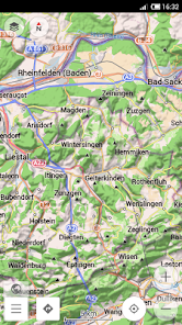
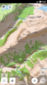
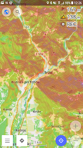
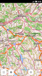
Contour lines plugin — OsmAnd is a plugin for 'Maps & Navigation — OsmAnd' app. The plugin provides extremely detailed offline topo maps that can be zoomed in and out without losing the quality. These topographic maps can also be complemented with a layer of 3D terrain representation ('hillshade'). Contour lines plugin — OsmAnd is a useful reference tool for hikers, tourists, cyclists, and any topography enthusiast.
To download the contour lines and hillshade maps, please go to OsmAnd > Download maps > choose the country you need > Contour Lines/Hillshade.
You can enable this layer of information by activating the plugin in OsmAnd > 'Plugins' and also enabling OsmAnd > Configure map > Contour Lines/Hillshade layer.
The global data (between 70 degrees north and 70 degrees south) is based on measurements by SRTM (Shuttle Radar Topography Mission) and ASTER (Advanced Spaceborne Thermal Emission and Reflection Radiometer), an imaging instrument onboard Terra, the flagship satellite of NASA's Earth Observing System. ASTER is a cooperative effort between NASA, Japan's Ministry of Economy, Trade and Industry (METI), and Japan Space Systems (J-spacesystems).
Aktualisiert am
Was die Sicherheit angeht, solltest du nachvollziehen, wie Entwickler deine Daten erheben und weitergeben. Die Datenschutz- und Sicherheitspraktiken können je nach Verwendung, Region und Alter des Nutzers variieren. Diese Informationen wurden vom Entwickler zur Verfügung gestellt und können jederzeit von ihm geändert werden.

Keine Daten werden mit Drittunternehmen oder -organisationen geteilt

Keine Daten erhoben
Bewertungen und Rezensionen
4.1
1.85 Tsg. Rezensionen
Neuigkeiten
Update Target API Level


