
B&G: Sailing & Navigation
In-app purchases
2.8star
454 reviews
10K+
Downloads

Everyone
info
About this app
The B&G app is designed to help you get the most out of your time on the water, and your electronics, whether you are cruising with your family or racing with your friends.
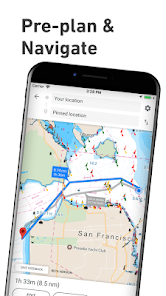
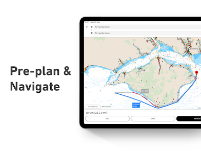
With detailed charting, weather and marine traffic information, route planning and navigating has never been simpler.
Get started –
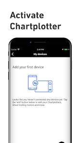
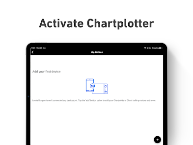
The B&G app can be used as a standalone or synced with your system, get started by connecting and registering your display to your phone via the app...
Explore more -
Use the app to plan your routes and waypoints in advance or when navigating out and about on the water, the detailed charts, auto routing and live AIS allow you to have all the information you need at your fingertips.
Simply download offline charts, save your favourite routes and waypoints in the app, so you can enjoy your time on the water and make the most of your sailing time.
The B&G app gives you:
- Activation/Registration of your B&G chartplotter
- Waypoints, routes and trails
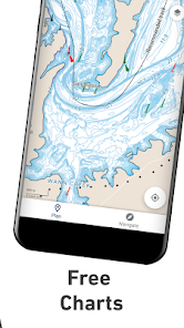
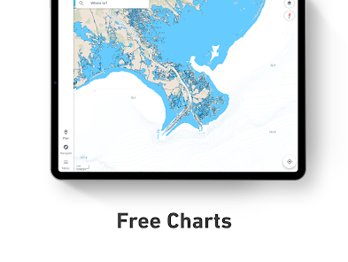
- Detailed C-MAP charting
- Marine weather forecast
- Real-time AIS
- Auto routing direct to your favourite spots
- Offline maps
- Personalization of your maps
- Thousands of points of interest, including relevant information about marinas, harbours, beaches, shops and much more.
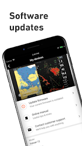
Functionality involving direct integration with devices B&G requires NOS software versions of 20.0 and above. Please check for compatibility with your device model:
Vulcan R
Zeus 2&3 GH
Zeus 3
The B&G app updates on a continuous basis to make sure you get the best experience and to bring you the most up-to-date maps and functionalities. Be sure to check in for updates regularly.
C-MAP maps can be used online free. You can also purchase and enjoy downloadable maps in remote areas without connection.
Try our 14 day free trial!
With detailed charting, weather and marine traffic information, route planning and navigating has never been simpler.
Get started –
The B&G app can be used as a standalone or synced with your system, get started by connecting and registering your display to your phone via the app...
Explore more -
Use the app to plan your routes and waypoints in advance or when navigating out and about on the water, the detailed charts, auto routing and live AIS allow you to have all the information you need at your fingertips.
Simply download offline charts, save your favourite routes and waypoints in the app, so you can enjoy your time on the water and make the most of your sailing time.
The B&G app gives you:
- Activation/Registration of your B&G chartplotter
- Waypoints, routes and trails
- Detailed C-MAP charting
- Marine weather forecast
- Real-time AIS
- Auto routing direct to your favourite spots
- Offline maps
- Personalization of your maps
- Thousands of points of interest, including relevant information about marinas, harbours, beaches, shops and much more.
Functionality involving direct integration with devices B&G requires NOS software versions of 20.0 and above. Please check for compatibility with your device model:
Vulcan R
Zeus 2&3 GH
Zeus 3
The B&G app updates on a continuous basis to make sure you get the best experience and to bring you the most up-to-date maps and functionalities. Be sure to check in for updates regularly.
C-MAP maps can be used online free. You can also purchase and enjoy downloadable maps in remote areas without connection.
Try our 14 day free trial!
Updated on
Safety starts with understanding how developers collect and share your data. Data privacy and security practices may vary based on your use, region and age The developer provided this information and may update it over time.


Ratings and reviews
2.8
388 reviews

Timo Budarz
- Flag inappropriate
10 July 2023
I have a full B&G setup on my boat including a Vulcan9, two Triton2 displays, and a lot of NMEA2k sensors. I was hoping this would augment the system well. Instead it is full of bugs. On both my phone and iPad, I fail to see wind data even though color legends show up, no indicators show up on the maps. There is an "explore nearby" section that eternally stays in a loading (flashing) mode regardless of internet strength. What it does do is allows a screen mirroring of my Vulcan.
7 people found this review helpful

Joseph Huberman
- Flag inappropriate
11 July 2022
I was happy with it at first, however in order to sign into the app you must have an internet connection. Once signed in the connection is no longer needed. I had to reboot and then needed internet to get back in. Unacceptable if I depend on it. The good news. The chart download is very flexible and the charts are clear and can be zoomed in as much as you want. It offered contour lines as an option which made depths very clear. Routes are easy. Create a start & finish the app does the rest.
8 people found this review helpful
Navico Norway AS
13 July 2022
Thank you for using our app and for your feedback. We will pass your comment to our development team.

Paul Seeberg
- Flag inappropriate
18 July 2021
I have a lot of B&G equipment on my boat. A big fan of the products. This app, not so much. Pretty much nothing works. Have deleted it and re-installed a few times. Now I have a blank map screen. If I go into select menu items (usually download offline maps) the app closed. I know from experience, if the app closes enough times, the maps show up (not always complete however) Nothing works consistently. IF the maps show up, not all the channel markers show up . Woods hole has a sea of channel markers. None are showing up at all now. Sometimes only shows a chart segment of a select area. See like 18 boats on AIS. I KNOW there are a TON of boats with AIS on nearby ( I can see in other apps) . Using (at this writing) a new Galaxy S21 Ultra. Plenty of power and space on the device. Nice to see my plotter data here. I wish i could see details about map items in a popup (like channel marker details, etc) Been playing with the app for a couple hours. Can't get it to work with any consistency. Maybe it is me, but there is no way this could be a chartplotter replacement. Can be useful for updating chart items (waypoints, etc) It should not be this hard. Rebooted and cleared data several times. Not ready for prime time, sadly. I really wanted this app to work.
29 people found this review helpful
Navico Norway AS
23 July 2021
Thank you for using our app and for your detailed feedback.
We are facing an issue with our app and our development team is working on a fix.
Kindly contact us via the Help & Feedback option within the app and we'll be happy to help you.
What's new
In this release we've redesigned and improved the offline maps experience for Premium users. Give it a try!
As always, we've also fixed bugs to improve the quality of the app.
As always, we've also fixed bugs to improve the quality of the app.


