ShipAtlas by Maritime Optima
In-App-Käufe
4.2star
2.45 Tsg. Rezensionen
500 Tsg.+
Downloads

Jedes Alter
info

Über diese App
The best app for individuals and consumers interested in following ships.
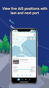
Download now and get live AIS ship positions with processed data from more than 700 satellites and terrestrial senders.
Live AIS ship tracking at your fingertips.
ShipAtlas is a FREEMIUM app for everyone interested in AIS vessel tracking and trades, port activities, congestions, sea routes, marine weather, ice conditions, piracy zones and marine maps.
Every second we collect raw AIS data from more than 700 AIS satellites, terrestrial senders, and dynamic AIS sources. We spend time and knowledge in data wrangling, cleaning, and unifying messy and processing complex data sets to give you high quality data.
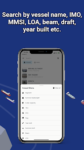
Search for vessels by vessel name, IMO or MMSI, or port names and type. Combine searches with more detailed info such as LOA, beam, draft and year built. Search for ports by port name, country or cargo type.
The vessels are divided into types (segments and sub-segments). Select and deselect vessel segments and sub-segments to get a quick overview of vessels within the segment you are interested in.
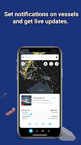
Set notifications on vessels and ports and get updates in real-time.
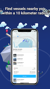
Turn on your location and find all the vessels nearby you, in a radius of 10 km.
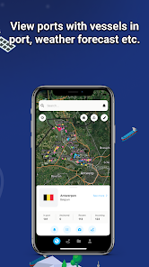
Access daily updated marine information: port activities, tides, local time, congestion, marine weather, ice conditions, and piracy.
Find canals restrictions, view vessels waiting at anchorage, study the activity of the ports, and quickly find real-time bunker prices and availability in more than 5 200 ports.
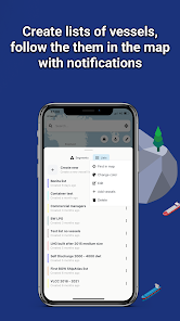
Create an unlimited number of vessel lists matching your search criteria and follow the ships live in the map.
Get the historical AIS data for all vessels, listed or shown as vessel tracks in the map.
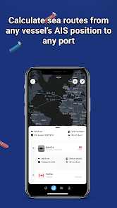
The quick and easy-to-use sea route calculator will give you the ETA, distance in nm, time at sea and estimated bunker consumption. Route from any vessel's real-time AIS position to any port, or between ports.
Use the same login on your mobile as on your laptop/desktop. Your data is automatically synced on all your devices.
A dedicated support chat is integrated in the app and we are happy to assist you at any time.
The data quality, the easy-to-use interface and design, and the price makes ShipAtlas one of the best vessel tracking apps there is.
Most features are free but you can upgrade to a paid subscription inside the app and access more features. In-app purchases from €10 per month (on web).
We hope you'll give ShipAtlas by Maritime Optima a try!
Visit our website to learn more:
https://maritimeoptima.com/shipatlas
Download now and get live AIS ship positions with processed data from more than 700 satellites and terrestrial senders.
Live AIS ship tracking at your fingertips.
ShipAtlas is a FREEMIUM app for everyone interested in AIS vessel tracking and trades, port activities, congestions, sea routes, marine weather, ice conditions, piracy zones and marine maps.
Every second we collect raw AIS data from more than 700 AIS satellites, terrestrial senders, and dynamic AIS sources. We spend time and knowledge in data wrangling, cleaning, and unifying messy and processing complex data sets to give you high quality data.
Search for vessels by vessel name, IMO or MMSI, or port names and type. Combine searches with more detailed info such as LOA, beam, draft and year built. Search for ports by port name, country or cargo type.
The vessels are divided into types (segments and sub-segments). Select and deselect vessel segments and sub-segments to get a quick overview of vessels within the segment you are interested in.
Set notifications on vessels and ports and get updates in real-time.
Turn on your location and find all the vessels nearby you, in a radius of 10 km.
Access daily updated marine information: port activities, tides, local time, congestion, marine weather, ice conditions, and piracy.
Find canals restrictions, view vessels waiting at anchorage, study the activity of the ports, and quickly find real-time bunker prices and availability in more than 5 200 ports.
Create an unlimited number of vessel lists matching your search criteria and follow the ships live in the map.
Get the historical AIS data for all vessels, listed or shown as vessel tracks in the map.
The quick and easy-to-use sea route calculator will give you the ETA, distance in nm, time at sea and estimated bunker consumption. Route from any vessel's real-time AIS position to any port, or between ports.
Use the same login on your mobile as on your laptop/desktop. Your data is automatically synced on all your devices.
A dedicated support chat is integrated in the app and we are happy to assist you at any time.
The data quality, the easy-to-use interface and design, and the price makes ShipAtlas one of the best vessel tracking apps there is.
Most features are free but you can upgrade to a paid subscription inside the app and access more features. In-app purchases from €10 per month (on web).
We hope you'll give ShipAtlas by Maritime Optima a try!
Visit our website to learn more:
https://maritimeoptima.com/shipatlas
Aktualisiert am
Was die Sicherheit angeht, solltest du nachvollziehen, wie Entwickler deine Daten erheben und weitergeben. Die Datenschutz- und Sicherheitspraktiken können je nach Verwendung, Region und Alter des Nutzers variieren. Diese Informationen wurden vom Entwickler zur Verfügung gestellt und können jederzeit von ihm geändert werden.


Bewertungen und Rezensionen
4.2
2.38 Tsg. Rezensionen
Neuigkeiten
Improved features and bug fixes.
Support für diese App
phone
Telefonnummer
+4747010704


