Netherland Topo Maps
Reklamalar mavjudIlova ichida xaridlar
10 ming+
Yuklanmalar

Hamma uchun
info
Bu ilova haqida
Easy to use Outdoor/Offline GPS navigation app with access to the best topographic maps and satellite images for Netherland.
Turn your Andoid Phone/Tablet into an outdoor GPS for trips into the backcountry WITHOUT CELL COVERAGE. This app gives you similar mapping options as you might know from Garmin or Magellan GPS handhelds.
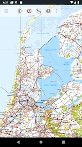
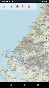
Included FREE map layers:
• Brtachtergrondkaart from Nationaalgeoregister.nl
• Topo Maps from Nationaalgeoregister.nl
• Orthographic map from Nationaalgeoregister.nl
• OpenStreetMaps : These crowdsourced maps are a very useful addition to other map layers. Contains many unique features.
• OpenCycleMaps: These maps are ideal to plan bicycle trips
• Geological Map (for biologists, geologists, miners, ...)
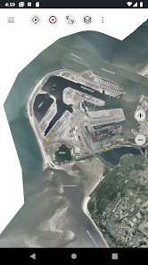
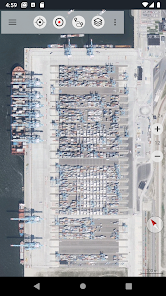
• ESRI Topographic
• ESRI Aerial Images
• ESRI Street Map
• Google Road Map (online access only)
• Google Satellite Images (online access only)
• Google Terrain Map (online access only)
• Bing Road Map (online access only)
• Bing Satellite Images (online access only)
• Earth At Night
• Hillshading overlay
• OpenSeaMap
Main features for outdoor-navigation:
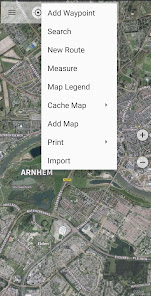
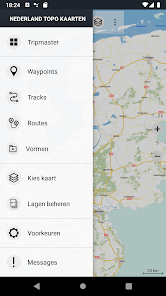
• Create and edit Waypoints
• GoTo-Waypoint-Navigation
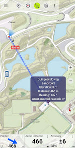
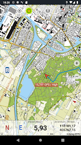
• Track Recording (with speed, elevation and accuracy profile)
• Tripmaster with fields for odometer, average speed, bearing, elevation, etc.
• GPX/KML/KMZ Export
• Search (placenames, POIs, streets)
• Customizable datafields in Map View and Tripmaster (e.g. Speed, Distance, Compass, ...)
• Share Waypoints, Tracks or Routes (via eMail, Whatsapp, Dropbox, Facebook, ..)
• Display coordinates in Lat/Lon, UTM or MGRS/USNG (Military Grid/ US National Grid)
• Record & share tracks with statistics & elevation profile
• Rotate map (Track Up & North Up)
• Get Elevation by long click on map
• Track Replay
• and many more ...
Available Pro features: (Pro features available via In App Purchase)
• Offline Use - no cell coverage needed. No Roaming fees !
• Easy+Fast Bulk-download of map tiles for OFFLINE USAGE (not for Google and Bing maps)
• Create and edit Routes
• Route-Navigation (Point-to-Point Navigation)
• GPX/KML/KMZ Import of Waypoints/Routes/Tracks
• unlimited Waypoints & Tracks
• Add other Map Tile-Server
• No Ads
Offline Use:
All viewed map tiles are kept in cache. To cache large areas you need to purchase Pro features.
Use this navigation app for outdoor activities like hiking, biking, camping, climbing, riding, skiing, canoeing, hunting, offroad 4WD tours or search&rescue (SAR).
Add custom waypoints in longitude/latitude, UTM or MGRS/USNG format with WGS84 datum.
Import/Export/Share GPS-Waypoints/Tracks/Routes in GPX or Google Earth KML/KMZ format.
Preload FREE map data for areas without cell service (Pro feature !).
Comments and feature requests to aussiemaps@atlogis.com
Have a look at our other outdoor navigation apps: https://play.google.com/store/search?q=atlogis
+++ We DO NOT track any user activities or collect any user data ! +++
Turn your Andoid Phone/Tablet into an outdoor GPS for trips into the backcountry WITHOUT CELL COVERAGE. This app gives you similar mapping options as you might know from Garmin or Magellan GPS handhelds.
Included FREE map layers:
• Brtachtergrondkaart from Nationaalgeoregister.nl
• Topo Maps from Nationaalgeoregister.nl
• Orthographic map from Nationaalgeoregister.nl
• OpenStreetMaps : These crowdsourced maps are a very useful addition to other map layers. Contains many unique features.
• OpenCycleMaps: These maps are ideal to plan bicycle trips
• Geological Map (for biologists, geologists, miners, ...)
• ESRI Topographic
• ESRI Aerial Images
• ESRI Street Map
• Google Road Map (online access only)
• Google Satellite Images (online access only)
• Google Terrain Map (online access only)
• Bing Road Map (online access only)
• Bing Satellite Images (online access only)
• Earth At Night
• Hillshading overlay
• OpenSeaMap
Main features for outdoor-navigation:
• Create and edit Waypoints
• GoTo-Waypoint-Navigation
• Track Recording (with speed, elevation and accuracy profile)
• Tripmaster with fields for odometer, average speed, bearing, elevation, etc.
• GPX/KML/KMZ Export
• Search (placenames, POIs, streets)
• Customizable datafields in Map View and Tripmaster (e.g. Speed, Distance, Compass, ...)
• Share Waypoints, Tracks or Routes (via eMail, Whatsapp, Dropbox, Facebook, ..)
• Display coordinates in Lat/Lon, UTM or MGRS/USNG (Military Grid/ US National Grid)
• Record & share tracks with statistics & elevation profile
• Rotate map (Track Up & North Up)
• Get Elevation by long click on map
• Track Replay
• and many more ...
Available Pro features: (Pro features available via In App Purchase)
• Offline Use - no cell coverage needed. No Roaming fees !
• Easy+Fast Bulk-download of map tiles for OFFLINE USAGE (not for Google and Bing maps)
• Create and edit Routes
• Route-Navigation (Point-to-Point Navigation)
• GPX/KML/KMZ Import of Waypoints/Routes/Tracks
• unlimited Waypoints & Tracks
• Add other Map Tile-Server
• No Ads
Offline Use:
All viewed map tiles are kept in cache. To cache large areas you need to purchase Pro features.
Use this navigation app for outdoor activities like hiking, biking, camping, climbing, riding, skiing, canoeing, hunting, offroad 4WD tours or search&rescue (SAR).
Add custom waypoints in longitude/latitude, UTM or MGRS/USNG format with WGS84 datum.
Import/Export/Share GPS-Waypoints/Tracks/Routes in GPX or Google Earth KML/KMZ format.
Preload FREE map data for areas without cell service (Pro feature !).
Comments and feature requests to aussiemaps@atlogis.com
Have a look at our other outdoor navigation apps: https://play.google.com/store/search?q=atlogis
+++ We DO NOT track any user activities or collect any user data ! +++
Oxirgi yangilanish
Xavfsizlik — dastur ishlab chiquvchilar maʼlumotlaringizni qanday jamlashi va ulashishini tushinishdan boshlanadi. Maʼlumotlar maxfiyligi va xavfsizlik amaliyotlari ilovadan foydalanish, hudud va yoshga qarab farq qilishi mumkin. Bu axborot dastur ishlab chiquvchi tomonidan taqdim etilgan va keyinchalik yangilanishi mumkin.

Bu ilova tashqi hamkorlarga quyidagi turdagi maʼlumotlarini ulashishi mumkin
Men haqimda, Ilova tarixi va yana 2 ta

Hech qanday maʼlumot jamlanmagan
Dastur ishlab chiquvchilar axborot jamlanishini qanday aytishi haqida batafsil

Maʼlumotlar uzatish vaqtida shifrlanadi

Maʼlumotlarni oʻchirishni soʻrashingiz mumkin
Nima yangiliklar
・Improvements & Fixes


