
Drone Scanner
2.7star
409 reviews
100K+
Downloads

Everyone
info


About this app
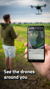
Transform your phone or tablet into a drone scanner and track all the nearby flights over Direct / Broadcast Remote ID standards. Browse real-time data about drones on a detailed map highlighting specific flying space zones. Download Drone Scanner for free and discover what drones fly above your head.
Favourite features:
- Discover more about drones flying nearby in real-time
- Examine detailed information broadcasted by drones via Bluetooth 4, Bluetooth 5, Wi-Fi Beacon, and Wi-Fi NAN
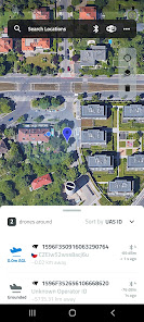
- Browse a detailed map with your location and all nearby aircraft
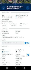
- Check available data about drones, including real-time height, direction, pilot identification, pilot position, operation description, and location history
- Various flying zones marked and highlighted on the map
- Easy export of collected data
- Continuously updated to reflect the latest EU & US regulations
All these features you find in Drone Scanner – a free app for tracking drones. The app is developed by Dronetag company manufacturing devices for drone remote identification.
How it works
Anyone can quickly identify what drones are flying in the sky nearby. Direct Remote ID is a feature that transmits live flight data via Bluetooth or Wi-Fi to the surrounding area. Drone manufacturers use various technologies to build an identification feature in new drones. Pilots of older drones are using add-on devices, enabling them to become digitally visible. With hardware on your smartphone, Drone Scanner can receive and read broadcasted data.
Favourite features:
- Discover more about drones flying nearby in real-time
- Examine detailed information broadcasted by drones via Bluetooth 4, Bluetooth 5, Wi-Fi Beacon, and Wi-Fi NAN
- Browse a detailed map with your location and all nearby aircraft
- Check available data about drones, including real-time height, direction, pilot identification, pilot position, operation description, and location history
- Various flying zones marked and highlighted on the map
- Easy export of collected data
- Continuously updated to reflect the latest EU & US regulations
All these features you find in Drone Scanner – a free app for tracking drones. The app is developed by Dronetag company manufacturing devices for drone remote identification.
How it works
Anyone can quickly identify what drones are flying in the sky nearby. Direct Remote ID is a feature that transmits live flight data via Bluetooth or Wi-Fi to the surrounding area. Drone manufacturers use various technologies to build an identification feature in new drones. Pilots of older drones are using add-on devices, enabling them to become digitally visible. With hardware on your smartphone, Drone Scanner can receive and read broadcasted data.
Updated on
Safety starts with understanding how developers collect and share your data. Data privacy and security practices may vary based on your use, region, and age. The developer provided this information and may update it over time.

No data shared with third parties
Learn more about how developers declare sharing

No data collected
Learn more about how developers declare collection
Ratings and reviews
2.8
380 reviews

David Quick
- Flag inappropriate
- Show review history
August 22, 2023
The app works great, however I'd like to have the ability to save the trace showing exactly what your drone's path was. So far the only way I can find to do so is to take a screenshot. Also, you loose that trace if you turn off the transponder. I'd love to have the ability to "save" before closing the app. Partly because if Karen accuses you of flying over her you have a way of showing you didn't.
58 people found this review helpful

John F
- Flag inappropriate
July 10, 2024
I had this app open, and my drone turned on using the DJI Fly app. The DJI Fly app said clear to take off, which meant it was broadcasting the ID,and this app showed zero drones. I tried using the app iontwo different devices at the same time and it showed zero drones. Then I tried it on just one device separate from the DJI Fly app by itself and it still showed zero drones in the area. The drone was no more than 5 feet away. What good is it if it doesn't work. I'm surprised it has a 2.8 rate.
1 person found this review helpful
Dronetag
July 11, 2024
Hello John. The DJI uses Wi-Fi protocols for Remote ID with a long delay in refresh, we tested the app with these and in some cases, we did not receive any data for minutes. Please note that the app is entirely dependent on the drone refresh rate and phone's WiFi power saving setup.

John Ferguson
- Flag inappropriate
July 6, 2024
Hangs when starting the app, causing the need to kill it and restart it several times. This happens with both android 10 and 14.
5 people found this review helpful
What's new
We have added an initial version of our data spoof detection, along with fixes for a few minor issues.


