
Mapy.cz: maps & navigation
Contains adsIn-app purchases
4.5star
227K reviews
5M+
Downloads

Rated for 3+
info


About this app
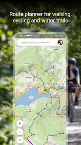
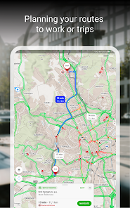
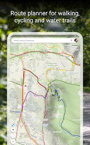
PLAN YOUR ROUTE
- hiking and cycling trails
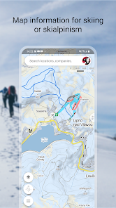
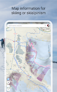
- cross-country skiing and ski-alpine trails
- unique “travel tips” feature plans a trip through the most interesting places in the area
- route elevation profile
- 5-day weather, temperature, wind and precipitation forecasts for any location on earth
BROWSE THE TOURIST MAP OF THE WHOLE WORLD
- hiking trails, bike trails, singletracks and single trails
- marking of roads, mixed cycle paths, unpaved paths and footpaths
- hillshade anywhere in the world, marking of ferrata and their difficulty
- educational trails, pedestrian closures, national park zones
- routes for wheelchair users
SWITCH TO OTHER MAP LAYERS
- aerial map of the world
- panoramic images of Czech streets and 3D view
- winter maps with up-to-date cross-country ski trails and ski resorts
- traffic map with current traffic, closures and parking zones in the Czech Republic
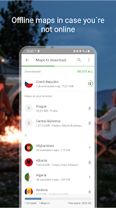
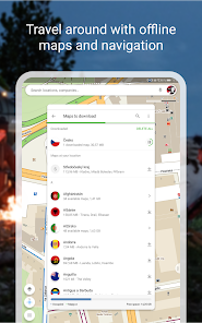
DOWNLOAD OFFLINE MAPS
- offline tourist map of the whole world with hiking and cycling trails
- offline voice navigation for drivers, cyclists and pedestrians
- offline winter maps of the Czech Republic with cross-country skiing trails and ski resorts
- individual regions for download and navigation
- search for places and plan routes around the world even without a signal
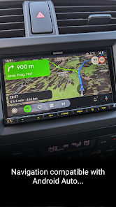
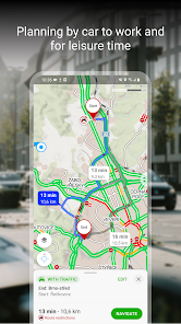
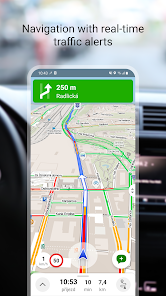
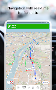
FREE NAVIGATION FOR DRIVERS, CYCLISTS AND PEDESTRIANS
- clear instructions on which lane to get into
- highlighting of roundabout exits
- ability to avoid toll lanes
- dark mode in the navigation
- sharing arrival time, route and current location via SMS, email or chat
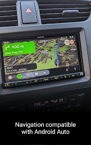
- view navigation onto the large on-board display via Android Auto
- view navigation onto the large on-board display via Apple Car Play
- speeding alerts and speed cameras for the Czech Republic
- important notifications from other drivers about accidents, police patrols, roadblocks, road closures and roadworks in the Czech Republic
- the latest traffic situation in the Czech Republic with an overview of traffic jams and alternative routes
- warnings on sections of frequent traffic accidents on Czech roads, sections without winter maintenance
SAVE TO MY MAPS
- save places, routes, photos and activities in clear folders
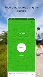
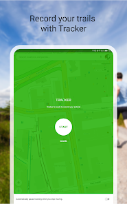
- track activities with Tracker for walking, cycling, running, cross-country skiing and hiking
- GPX file upload, GPX import and export
- synchronization of planned routes across devices
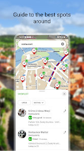
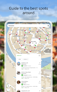
CHOOSE BY REVIEWS OF PLACES, RESTAURANTS AND SERVICES
- up-to-date user photos of what the place looks like
- users' experiences with food, service, ambience and price
- search by rating level and highlight top-rated establishments
RECOMMENDATIONS AND TIPS:
- you will need an internet connection to download the map
- to make the app work properly, turn on location services in your phone settings
- ror the location sharing function, this app will need access to background location data
- for questions or troubleshooting, use the form in the app settings
- using the app in the background with GPS running can reduce battery life
- join our user community at www.facebook.com/Mapy.cz/ to share your experience with the app, follow the latest news or suggest new features
- hiking and cycling trails
- cross-country skiing and ski-alpine trails
- unique “travel tips” feature plans a trip through the most interesting places in the area
- route elevation profile
- 5-day weather, temperature, wind and precipitation forecasts for any location on earth
BROWSE THE TOURIST MAP OF THE WHOLE WORLD
- hiking trails, bike trails, singletracks and single trails
- marking of roads, mixed cycle paths, unpaved paths and footpaths
- hillshade anywhere in the world, marking of ferrata and their difficulty
- educational trails, pedestrian closures, national park zones
- routes for wheelchair users
SWITCH TO OTHER MAP LAYERS
- aerial map of the world
- panoramic images of Czech streets and 3D view
- winter maps with up-to-date cross-country ski trails and ski resorts
- traffic map with current traffic, closures and parking zones in the Czech Republic
DOWNLOAD OFFLINE MAPS
- offline tourist map of the whole world with hiking and cycling trails
- offline voice navigation for drivers, cyclists and pedestrians
- offline winter maps of the Czech Republic with cross-country skiing trails and ski resorts
- individual regions for download and navigation
- search for places and plan routes around the world even without a signal
FREE NAVIGATION FOR DRIVERS, CYCLISTS AND PEDESTRIANS
- clear instructions on which lane to get into
- highlighting of roundabout exits
- ability to avoid toll lanes
- dark mode in the navigation
- sharing arrival time, route and current location via SMS, email or chat
- view navigation onto the large on-board display via Android Auto
- view navigation onto the large on-board display via Apple Car Play
- speeding alerts and speed cameras for the Czech Republic
- important notifications from other drivers about accidents, police patrols, roadblocks, road closures and roadworks in the Czech Republic
- the latest traffic situation in the Czech Republic with an overview of traffic jams and alternative routes
- warnings on sections of frequent traffic accidents on Czech roads, sections without winter maintenance
SAVE TO MY MAPS
- save places, routes, photos and activities in clear folders
- track activities with Tracker for walking, cycling, running, cross-country skiing and hiking
- GPX file upload, GPX import and export
- synchronization of planned routes across devices
CHOOSE BY REVIEWS OF PLACES, RESTAURANTS AND SERVICES
- up-to-date user photos of what the place looks like
- users' experiences with food, service, ambience and price
- search by rating level and highlight top-rated establishments
RECOMMENDATIONS AND TIPS:
- you will need an internet connection to download the map
- to make the app work properly, turn on location services in your phone settings
- ror the location sharing function, this app will need access to background location data
- for questions or troubleshooting, use the form in the app settings
- using the app in the background with GPS running can reduce battery life
- join our user community at www.facebook.com/Mapy.cz/ to share your experience with the app, follow the latest news or suggest new features
Updated on
Safety starts with understanding how developers collect and share your data. Data privacy and security practices may vary based on your use, region, and age. The developer provided this information and may update it over time.

No data shared with third parties
Learn more about how developers declare sharing

This app may collect these data types
Location, Photos and videos, and App activity

Data is encrypted in transit

You can request that data be deleted
Ratings and reviews
4.5
217K reviews

Dominik.D
- Flag inappropriate
September 28, 2024
Almost perfect terrain maps, I am impressed by the accuracy of the terrain mapping. My only comment would be on the color of the route after importing the .GPX map - the color of your own route is red as are some of the trails, I think there should be an option to choose the color for your own route, but it's not a big problem. I recommend the maps, of course. I can't give less than 5 stars.
2 people found this review helpful

Arjen Suijker
- Flag inappropriate
August 8, 2024
By far the best mapping app for adventurous hiking. The website is very useful for planning purposes, and the sharing functionality is seamless. The interface is intuitive. It is great that you can see all long distance hikes directly on the map almost everywhere on earth, this allows me to connect all these great trails to suit my own purposes. The routing works very well and makes improvising during hikes much easier.
9 people found this review helpful

Matej Rajčan
- Flag inappropriate
- Show review history
August 8, 2024
Edit: App freezes a lot now! This is due to it trying to download something from internet even when i have downloaded maps! Nothing helps but to force stop! and 15s start time is too much! One thing i miss is to mark your car location on map, it would be useful. Also, i am unable to turn on drivng mode without navigation. Other than that, very detailed maps, tracker function, offline maps is great. So far best navigation anywhere outside.
What's new
Once the next version of the app comes out, you can help us keep improving Mapy.cz by paying for the premium version. We offer our premium supporters new, advanced functions and unlimited offline map downloads. We will also gradually unlock Premium benefits for the most active members of our community.
The free version will still work as normal. The only difference will be the new option to save an offline map of one country including regional maps within the country and update it regularly.
The free version will still work as normal. The only difference will be the new option to save an offline map of one country including regional maps within the country and update it regularly.


