
Memory-Map for All
5.0star
765 reviews
10K+
Downloads

Everyone
info
About this app
Download maps for Offline GPS Navigation. No mobile data connection required.
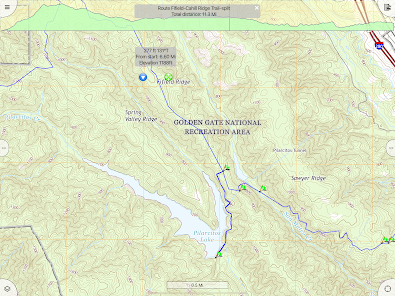
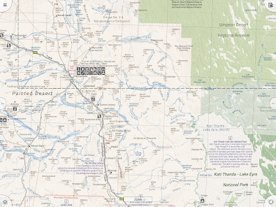
Your favorite maps and charts from OS maps, Hema, NOAA, and many more.
Fully customizable map, data display and toolbar buttons.
Powerful overlay data management, using nested categories and GPX files
Backup and load maps from thumb drive.
Use the same offline maps and share overlay data on desktop and mobile
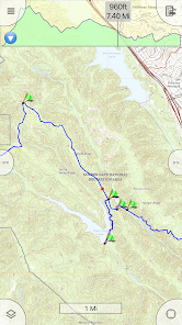
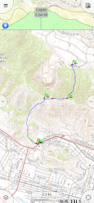
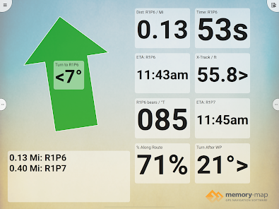
Interactive graphs of Terrain Elevation, GPS Altitude and Speed profile.
Note: This app complies with Google's scoped storage policy, which means that it does not access any data outside the app, except when explicitly importing or exporting files. If you have the legacy Memory-Map app, you have to install a separate copy of your maps in this app.
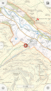
The Memory-Map for All app turns your phone or tablet into a full-featured Outdoor GPS or Marine Chart Plotter, and allows you to navigate with USGS Topo maps, NOAA Marine charts, and many other specialist maps, without needing a mobile internet signal.
Maps are downloaded on-the-fly and can be pre-loaded, so they are ready to be used offline. Once the app and maps are loaded to the phone or tablet, cellular network coverage or internet connection is not required for real time GPS navigation.
The Memory-Map for All app can be used as a standalone GPS navigator, but it can also be used in conjunction with the Windows PC or Mac app (free download) for planning, printing and loading up maps, waypoints and routes to the phone/tablet.
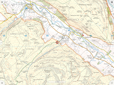
Memory-Map for All includes free access to 1:250,000 scale topographic maps and many other free maps around the world. More detailed maps are available for download and purchase with a free try-before-you-buy, time-limited demo option. Available maps include Ordnance Survey, Hema, USGS quads, NOAA, UKHO, and DeLorme. Maps can be used on your PC as well as your phone and tablet. The Cloud Sync feature allows you to keep the overlay data consistent on all your devices.
Features include:
Access a vast range of Worldwide maps and charts.
Automatically downloads a free map of your current location
Create and edit marks and routes.
Import and export marks, routes and tracks in the open GPX format
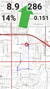
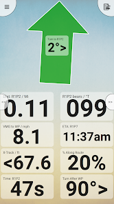
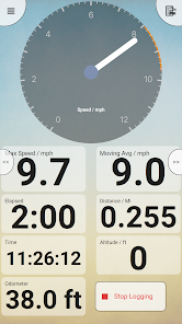
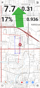
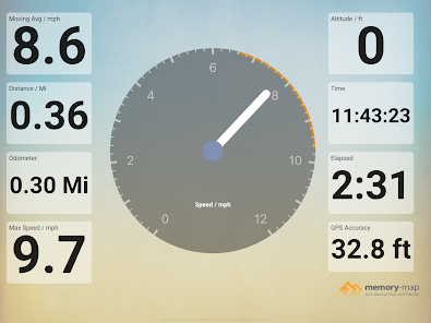
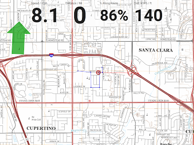
Display; Position, Course, Speed, Heading, Altitude and averages
Position coordinates include Lat/Long, UTM, GB Grid, Irish Grid, Military Grid.
Units displayed in Statute, Nautical or Metric, with separate unit setting for Height
Support for GPS and Compass sensors, where available.
Placename search index can be used offline.
Moving map, lock GPS position and automatically scroll the map
Records breadcrumb trail / tracklogs.
Share position marks, routes and tracklogs as GPX files
Full marine instrumentation features, with AIS, DSC and Anchor alarm
NMEA data interface via WiFi
Barometer & relative altitude
Your favorite maps and charts from OS maps, Hema, NOAA, and many more.
Fully customizable map, data display and toolbar buttons.
Powerful overlay data management, using nested categories and GPX files
Backup and load maps from thumb drive.
Use the same offline maps and share overlay data on desktop and mobile
Interactive graphs of Terrain Elevation, GPS Altitude and Speed profile.
Note: This app complies with Google's scoped storage policy, which means that it does not access any data outside the app, except when explicitly importing or exporting files. If you have the legacy Memory-Map app, you have to install a separate copy of your maps in this app.
The Memory-Map for All app turns your phone or tablet into a full-featured Outdoor GPS or Marine Chart Plotter, and allows you to navigate with USGS Topo maps, NOAA Marine charts, and many other specialist maps, without needing a mobile internet signal.
Maps are downloaded on-the-fly and can be pre-loaded, so they are ready to be used offline. Once the app and maps are loaded to the phone or tablet, cellular network coverage or internet connection is not required for real time GPS navigation.
The Memory-Map for All app can be used as a standalone GPS navigator, but it can also be used in conjunction with the Windows PC or Mac app (free download) for planning, printing and loading up maps, waypoints and routes to the phone/tablet.
Memory-Map for All includes free access to 1:250,000 scale topographic maps and many other free maps around the world. More detailed maps are available for download and purchase with a free try-before-you-buy, time-limited demo option. Available maps include Ordnance Survey, Hema, USGS quads, NOAA, UKHO, and DeLorme. Maps can be used on your PC as well as your phone and tablet. The Cloud Sync feature allows you to keep the overlay data consistent on all your devices.
Features include:
Access a vast range of Worldwide maps and charts.
Automatically downloads a free map of your current location
Create and edit marks and routes.
Import and export marks, routes and tracks in the open GPX format
Display; Position, Course, Speed, Heading, Altitude and averages
Position coordinates include Lat/Long, UTM, GB Grid, Irish Grid, Military Grid.
Units displayed in Statute, Nautical or Metric, with separate unit setting for Height
Support for GPS and Compass sensors, where available.
Placename search index can be used offline.
Moving map, lock GPS position and automatically scroll the map
Records breadcrumb trail / tracklogs.
Share position marks, routes and tracklogs as GPX files
Full marine instrumentation features, with AIS, DSC and Anchor alarm
NMEA data interface via WiFi
Barometer & relative altitude
Updated on
Safety starts with understanding how developers collect and share your data. Data privacy and security practices may vary based on your use, region and age. The developer provided this information and may update it over time.

No data shared with third parties
Learn more about how developers declare sharing

This app may collect these data types
Personal info

Data is encrypted in transit

You can request that data be deleted
Ratings and reviews
5.0
587 reviews

Nigel B
- Flag inappropriate
18 August 2025
The problem I am having is large random location errors when stationary for a while, and in particular if I go into a building (say a cafe). The location just bounces around like crazy. As well as looking silly, it adds spurious distance: on a recent walk it added 3 miles! This makes the track useless for sharing or reusing. Friends' using other apps don't seem to suffer the same problem. I could pause recording, but that's a real hassle. Maybe allowing thresholds on distance moved would help?

Bren Trevallion
- Flag inappropriate
- Show review history
11 July 2025
A year on from my first review, I'm happy to report that it is still as good: It's good for plotting my walks and runs in advance, but also whilst I'm on the move. For use in the mountains it is a handy navigational aid for use alongside traditional map and compass. Con - It would be good if I could rotate the map manually and automatically in the direction of travel.
1 person found this review helpful

Sorcha Egan
- Flag inappropriate
- Show review history
29 April 2025
Terrible app. Had the legacy version for years, which they've stopped maintaining, despite paying £100s for the mapping & licenses. The new version crashes regularly. Their customer service ('Ron') is purposefully unhelpful. We lost hundreds of tracks and he evaded every question when queried. EDIT: owner is saying we deleted the data - we were using the app, all of a sudden it wiped all tracks with no warning. What do I gain by lying? Many others say same thing happened to them - don't install!
1 person found this review helpful
Memory-Map, Inc.
25 April 2025
That doesn't sound right! I reviewed the support messages and Ron was professional and polite as always, but there is nothing he can do to recover data that has been deleted. We recommend you backup any valuable data you create in the app. Our crash statistics are below industry norms.
What's new
Requires Android 8 or later. Do not install on Android 6 or 7!
Remember search text
Redesigned icons for all screen resolution
Import custom mark/wp icons
Import MMNav CSV files
Edit multi-selected marks, routes and tracks
Improved GPS tracking
Connect to Bluetooth GPS
Bug-fixes
Remember search text
Redesigned icons for all screen resolution
Import custom mark/wp icons
Import MMNav CSV files
Edit multi-selected marks, routes and tracks
Improved GPS tracking
Connect to Bluetooth GPS
Bug-fixes
App support
phone
Phone number
+16072169195
About the developer
MEMORY-MAP, INC.
support@memory-map.com
51 Elm St
Trumansburg, NY 14886-9729
United States
+1 607-216-9195


