
Colorado Trail Explorer
4.2star
280 reviews
100K+
Downloads

Everyone
info


About this app
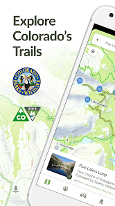
Discover and explore Colorado’s unique trail experiences with the Colorado Trail Explorer. Available for free, COTREX offers the most comprehensive trail map available for the state and is built atop data from over 230 trail managers.
View trails by allowed uses on the map, browse featured routes, download offline maps, record trips and notes in the field, complete challenges to earn badges, and share your experiences with the community. COTREX is your gateway into Colorado’s magnificent outdoors.
■ DISCOVER TRAILS & FEATURED ROUTES
– Browse or search to find trails and Feature Routes that match your activities or interests.
– Change activity type to dynamically filter trails on the map.
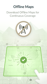
■ OFFLINE MAPS
– No cell coverage? No problem! Download maps ahead of time for a continuous experience that doesn’t depend on your network.
– COTREX offline maps are lightweight in size and easy to download.
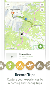
■ RECORD TRIPS & FIELD NOTES
– Capture the details of your outdoor experiences by recording Trips.
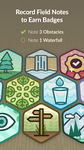
– Go beyond simple photos by taking and classifying rich Field Notes along the way. Choose from 45,000+ classifications that include trail conditions, species, rocks and minerals, historic places, points of interest, and much more.
– Seamlessly sync activity recorded on your devices with the web.
■ COMPLETE CHALLENGES TO EARN BADGES
– By recording and classifying Field Notes, you can complete Challenges and earn Badges for your profile.
■ SHARE WITH THE COMMUNITY
– Inform and inspire the entire COTREX community by sharing your Trips and Field Notes publicly or submitting Trip Reports.
– View activity feeds for all users or just the ones you follow.
– By sharing your experiences, you also help to inform trail managers about current conditions on the ground.
■ ABOUT COTREX
The Colorado Trail Explorer endeavors to map every trail in the state of Colorado in support of the Colorado the Beautiful Initiative. COTREX connects people, trails, and technology by coordinating the efforts of federal, state, county, and local agencies to create a comprehensive repository of recreational trails for public use.
This project is led by Colorado Parks and Wildlife (CPW) and Department of Natural Resources, but is only made possible through partnerships with organizations at every level statewide. COTREX represents a seamless network of trails managed by over 230 land managers.
■ DISCLAIMERS
[Battery Life] We do everything we can to make the app low power when recording, but GPS is notorious for reducing battery life
Terms: https://trails.colorado.gov/terms
Privacy Policy: https://trails.colorado.gov/privacy
View trails by allowed uses on the map, browse featured routes, download offline maps, record trips and notes in the field, complete challenges to earn badges, and share your experiences with the community. COTREX is your gateway into Colorado’s magnificent outdoors.
■ DISCOVER TRAILS & FEATURED ROUTES
– Browse or search to find trails and Feature Routes that match your activities or interests.
– Change activity type to dynamically filter trails on the map.
■ OFFLINE MAPS
– No cell coverage? No problem! Download maps ahead of time for a continuous experience that doesn’t depend on your network.
– COTREX offline maps are lightweight in size and easy to download.
■ RECORD TRIPS & FIELD NOTES
– Capture the details of your outdoor experiences by recording Trips.
– Go beyond simple photos by taking and classifying rich Field Notes along the way. Choose from 45,000+ classifications that include trail conditions, species, rocks and minerals, historic places, points of interest, and much more.
– Seamlessly sync activity recorded on your devices with the web.
■ COMPLETE CHALLENGES TO EARN BADGES
– By recording and classifying Field Notes, you can complete Challenges and earn Badges for your profile.
■ SHARE WITH THE COMMUNITY
– Inform and inspire the entire COTREX community by sharing your Trips and Field Notes publicly or submitting Trip Reports.
– View activity feeds for all users or just the ones you follow.
– By sharing your experiences, you also help to inform trail managers about current conditions on the ground.
■ ABOUT COTREX
The Colorado Trail Explorer endeavors to map every trail in the state of Colorado in support of the Colorado the Beautiful Initiative. COTREX connects people, trails, and technology by coordinating the efforts of federal, state, county, and local agencies to create a comprehensive repository of recreational trails for public use.
This project is led by Colorado Parks and Wildlife (CPW) and Department of Natural Resources, but is only made possible through partnerships with organizations at every level statewide. COTREX represents a seamless network of trails managed by over 230 land managers.
■ DISCLAIMERS
[Battery Life] We do everything we can to make the app low power when recording, but GPS is notorious for reducing battery life
Terms: https://trails.colorado.gov/terms
Privacy Policy: https://trails.colorado.gov/privacy
Updated on
Safety starts with understanding how developers collect and share your data. Data privacy and security practices may vary based on your use, region and age The developer provided this information and may update it over time.

No data shared with third parties
Learn more about how developers declare sharing

This app may collect these data types
Location, Personal info and 3 others

Data is encrypted in transit

You can request that data be deleted
Ratings and reviews
4.2
266 reviews

Tim Zander
- Flag inappropriate
4 August 2024
Great start to the app, lots of room to improve A few things to improve: 1) make landscape mode work with a phone 2) let there be a Jeep activity. When I'm offroading in my street legal SUV I'd like to see all routes which are legal for it. Maybe the intention is with the >50 ATV(which is the mode I'm using) but it seems like there may be cases where a wide atv is legal but jeeps are not? 3) allow adding a marker at any place, not just current location. Thanks for the work!
2 people found this review helpful

TJ Burr
- Flag inappropriate
- Show review history
26 September 2021
Great for Planning Your Hiking! I like the ability to save custom routes. I use it to pre-plan hikes by evaluating the distance and elevation gain. I also use it to adjust my route by checking distance and elevation gain of alternate routes. See you on the trail! #ColoMountaineer #HikingColorado 9/25/2021 - I'm still enjoying the app. It drains battery down when recording, but so do other fitness trackers. I use it to plan hikes, look at routes, navigating, etc. I rely on my Garmin for stats.
11 people found this review helpful

Maggie Michalowski
- Flag inappropriate
16 August 2023
+ Easy to track routes or make your own after the fact or as planing Downloadable maps is awesome Great info on all the trails I know of Elevation gain and loss (when it works) Free - Had to reinstall because it couldn't find my location Doesn't say trail difficulty. Would be a major plus for mountain biking Elevation gain/loss is buggy. By definition if I travel on a loop they should be equal but one is often several hundred feet off from the other Sometimes can't figure out that trails connect
9 people found this review helpful
What's new
- Wildfires and Prescribed Burns are now on the map
- Stability Improvements
- Stability Improvements


