
Canada Topo Maps
Contains adsIn-app purchases
4.6star
3.08K reviews
100K+
Downloads

Everyone
info
About this app
Easy to use outdoor navigation app with free access to the best available maps and aerial imagery for Canada.
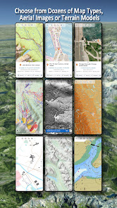
Choose between 30+ map layers (topos, aerials, sea charts, ...) to plan the perfect trip and
turn your Andoid Phone/Tablet into an outdoor GPS for offline trips into the backcountry.
*** Note: Please use Canada Base Map, Toporama or OpenStreetMap layer if you need most recent topo maps ! ***
Add easily maps from other sources (GeoPDF, GeoTiff, Online Map Services like WMS, ...)
Available base map layers for Canada:
• Topomaps Canada (CanMatrix, seamless coverage at scales 1:50.000 and 1:250.000), incl. USA 1:24.000 - 1:250.000), > 30.000 maps
• Canada Basemap CBMT (CanVec, NTDB, Atlas of Canada)
• Toporama Maps Canada in EN&FR (CanVec, NTDB, Atlas of Canada)
• CanTopo (new Canada Topos at 1:50.000, partial coverage of Canada, mainly in the North)
• Ontario LIO Topo Maps
• Québec Topo Maps 1:20.000
• Saskatchewan Orthophotos
• Nova Scotia Othophotos
• British Columbia Topo Maps
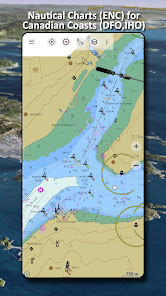
• Nautical Charts ENC
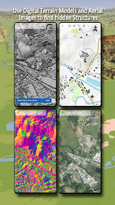
• Digital Elevation Model
• HRDEM (HiRes Elevation Model, parts of Canada)
Worldwide basemap layers:
• OpenStreetMaps (5 different map layouts), also downloadable in space saving vectorformat
• Google Maps (Satellite images, Road- and Terrain-Map)
• Bing Maps (Satellite images, Road-Map)
• Waze Roads
• Earth At Night
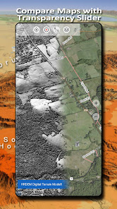
Configure a basemap layer as an overlay and utilize a transparency fader to seamlessly compare maps with each other.
Add maps from other sources:
• Import raster maps in GeoPDF, GeoTiff, MBTiles or Ozi (Oziexplorer OZF2 & OZF3)
• Add web mapping services as WMS or WMTS/Tileserver
• Import OpenStreetMaps in Vectorformat, eg complete USA for just some GBs
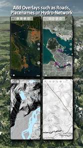
Available Canada map Overlays - add additional information to any other base map:
• CanVec features such as Transportation, Contourlines, Hydronetwork, Toponymic Features, etc.
• Nova Scotia Roads
• Yukon Transportation
Available worldwide overlays:
• Hillshading overlay
• 20m Contourlines
• OpenSeaMap
There is no perfect map. Toggle between the different map layers or use the compare maps feature to find the most interesting route. Especially the old CanMatrix Topos contain many small pathes or other features that are missing on modern maps.
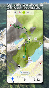
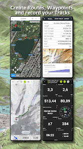
Main features for outdoor-navigation:
• Download map data for OFFLINE USAGE
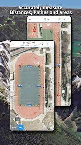
• Measure pathes and aereas
• Create and edit Waypoints
• GoTo-Waypoint-Navigation
• Create and edit Routes
• Route-Navigation (Point-to-Point Navigation)
• Track Recording (with speed, elevation and accuracy profile)
• Tripmaster with fields for odometer, average speed, bearing, elevation, etc.
• GPX/KML/KMZ Import/Export
• Search (placenames, POIs, streets)
• Get elevation and distance
• Customizable datafields in Map View and Tripmaster (e.g. Speed, Distance, Compass, ...)
• Share Waypoints, Tracks or Routes (via eMail, Dropbox, WhatsApp, ..)
• Use coordinates in WGS84, UTM or MGRS/USNG (Military Grid/ US National Grid),
• Track Replay
• and many more ...
Use this navigation app for outdoor activities like hiking, biking, camping, climbing, riding, skiing, canoeing, hunting, snowmobile tours, offroad 4WD tours or search&rescue (SAR).
Add custom waypoints in longitude/latitude, UTM or MGRS/USNG format with WGS84 datum.
Import/Export/Share GPS-Waypoints/Tracks/Routes in GPX or Google Earth KML/KMZ format.
Canadian topographic maps are enhanced with Atlogis® hillshading and placenames.
Credits for topographic map data: "© Department of Natural Resources Canada. All rights reserved."
Please send questions, comments and feature requests to support@atlogis.com
Choose between 30+ map layers (topos, aerials, sea charts, ...) to plan the perfect trip and
turn your Andoid Phone/Tablet into an outdoor GPS for offline trips into the backcountry.
*** Note: Please use Canada Base Map, Toporama or OpenStreetMap layer if you need most recent topo maps ! ***
Add easily maps from other sources (GeoPDF, GeoTiff, Online Map Services like WMS, ...)
Available base map layers for Canada:
• Topomaps Canada (CanMatrix, seamless coverage at scales 1:50.000 and 1:250.000), incl. USA 1:24.000 - 1:250.000), > 30.000 maps
• Canada Basemap CBMT (CanVec, NTDB, Atlas of Canada)
• Toporama Maps Canada in EN&FR (CanVec, NTDB, Atlas of Canada)
• CanTopo (new Canada Topos at 1:50.000, partial coverage of Canada, mainly in the North)
• Ontario LIO Topo Maps
• Québec Topo Maps 1:20.000
• Saskatchewan Orthophotos
• Nova Scotia Othophotos
• British Columbia Topo Maps
• Nautical Charts ENC
• Digital Elevation Model
• HRDEM (HiRes Elevation Model, parts of Canada)
Worldwide basemap layers:
• OpenStreetMaps (5 different map layouts), also downloadable in space saving vectorformat
• Google Maps (Satellite images, Road- and Terrain-Map)
• Bing Maps (Satellite images, Road-Map)
• Waze Roads
• Earth At Night
Configure a basemap layer as an overlay and utilize a transparency fader to seamlessly compare maps with each other.
Add maps from other sources:
• Import raster maps in GeoPDF, GeoTiff, MBTiles or Ozi (Oziexplorer OZF2 & OZF3)
• Add web mapping services as WMS or WMTS/Tileserver
• Import OpenStreetMaps in Vectorformat, eg complete USA for just some GBs
Available Canada map Overlays - add additional information to any other base map:
• CanVec features such as Transportation, Contourlines, Hydronetwork, Toponymic Features, etc.
• Nova Scotia Roads
• Yukon Transportation
Available worldwide overlays:
• Hillshading overlay
• 20m Contourlines
• OpenSeaMap
There is no perfect map. Toggle between the different map layers or use the compare maps feature to find the most interesting route. Especially the old CanMatrix Topos contain many small pathes or other features that are missing on modern maps.
Main features for outdoor-navigation:
• Download map data for OFFLINE USAGE
• Measure pathes and aereas
• Create and edit Waypoints
• GoTo-Waypoint-Navigation
• Create and edit Routes
• Route-Navigation (Point-to-Point Navigation)
• Track Recording (with speed, elevation and accuracy profile)
• Tripmaster with fields for odometer, average speed, bearing, elevation, etc.
• GPX/KML/KMZ Import/Export
• Search (placenames, POIs, streets)
• Get elevation and distance
• Customizable datafields in Map View and Tripmaster (e.g. Speed, Distance, Compass, ...)
• Share Waypoints, Tracks or Routes (via eMail, Dropbox, WhatsApp, ..)
• Use coordinates in WGS84, UTM or MGRS/USNG (Military Grid/ US National Grid),
• Track Replay
• and many more ...
Use this navigation app for outdoor activities like hiking, biking, camping, climbing, riding, skiing, canoeing, hunting, snowmobile tours, offroad 4WD tours or search&rescue (SAR).
Add custom waypoints in longitude/latitude, UTM or MGRS/USNG format with WGS84 datum.
Import/Export/Share GPS-Waypoints/Tracks/Routes in GPX or Google Earth KML/KMZ format.
Canadian topographic maps are enhanced with Atlogis® hillshading and placenames.
Credits for topographic map data: "© Department of Natural Resources Canada. All rights reserved."
Please send questions, comments and feature requests to support@atlogis.com
Updated on
Safety starts with understanding how developers collect and share your data. Data privacy and security practices may vary based on your use, region and age The developer provided this information and may update it over time.

This app may share these data types with third parties
Personal info, App activity and 2 others

No data collected
Learn more about how developers declare collection

Data is encrypted in transit

You can request that data be deleted
Ratings and reviews
4.6
2.68K reviews

AliciaCraigSmith
- Flag inappropriate
31 July 2024
I have been using this app (pro version) for 2 seasons of backcountry canoeing. It has been reliable and easy to use with a variety of devices. Offline maps work well. Sharing waypoints and routes between devices is available, though it requires exporting data from one device and importing to the other. One criticism would be that it doesn't let you start navigating a route mid route, instead providing heading and distance to the route start point. Otherwise, it has been excellent.
4 people found this review helpful

Mike Bradford
- Flag inappropriate
7 August 2024
Reliable, easy to use and very flexible. As a guide, my group was on day 18 of a 21 day backcountry trip in the rockies and we ended up in a valley that had been washed out from the previous year's flooding. Using this app, on my coveted phone battery, I got our UTM and a ping on the downloaded map. I was able to cross reference with 2 mountains. Saved our butts a lot of unnecessary bush wacking.
2 people found this review helpful

Cody Geiger
- Flag inappropriate
- Show review history
30 May 2024
I was looking for something to measure point to point distance since Google Maps doesn't, and I can't get Foreflight on an Android device. Got exactly what I needed within 30 seconds of opening it. The 1:50000 scale is the same that I use for air SAR as well, so it should be very useful. I will definitely consider buying pro if I start using it more. ... After using this a little longer, it would be useful to be able to create a "go to" route by entering a bearing and distance.
34 people found this review helpful
What's new
・Fixes


