
Colorado Trail Explorer
4.2star
302 reviews
100K+
Downloads

Everyone
info


About this app
Discover and explore Colorado’s unique trail experiences with the Colorado Trail Explorer (COTREX). Available for free and without ads, COTREX offers the most comprehensive official trail map in the state and is a collaborative effort spanning over 230 trail managers.
View trails by allowed uses on the map, browse featured routes, download offline maps, view closures, alerts, wildfire boundaries and avalanche forecasts, record trips and notes in the field, and share your experiences with the community. COTREX is your gateway into Colorado’s magnificent outdoors.
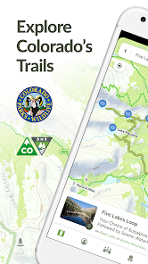
■ DISCOVER TRAILS & FEATURED ROUTES
Browse or search to find trails and recommendations from experts that match your activities or interests.
Change activity type to dynamically filter trails on the map whether hiking, biking, riding, skiing, snowshoeing and more.
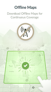
■ DOWNLOAD MAPS
No cell coverage? No problem! Download free maps ahead of time for a continuous experience that doesn’t depend on your network.
COTREX offline maps are lightweight in size and easy to download.
■ VIEW ADVISORIES, CLOSURES, AND CONDITIONS FROM OFFICIAL SOURCES
More land managers use COTREX than any other app in Colorado to show their real-time closures and advisories. Know when and where a trail is closed before you leave the house, review real-time wildfire updates, and see daily avalanche forecasts all straight from the experts.
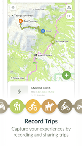
■ PLAN AND RECORD YOUR TRIPS
Measure the distance and elevation profile for any trail segment quickly and easily to plan your next trip.
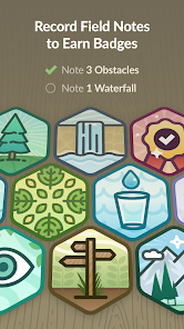
Capture the details of your outdoor experiences by recording Trips.
■ SHARE WITH THE COMMUNITY
Inform and inspire the entire COTREX community by sharing your Trips and Field Notes publicly or submitting Trip Reports.
By sharing your experiences, you also help to inform trail managers about current conditions on the ground.
■ ABOUT COTREX
Colorado Trail Explorer aims to map every official trail in the state of Colorado. COTREX connects people, trails, and technology by coordinating the efforts of federal, state, county, and local agencies to create a comprehensive repository of recreational trails for public use.
COTREX is unique in that the app only shows information from official sources. No unreliable crowdsourced information or recommendations from someone on the other side of the country. Everything you see in COTREX has been reviewed and approved by the managers and experts local to that area.
This project is led by Colorado Parks and Wildlife (CPW) and Department of Natural Resources, but is only made possible through partnerships with organizations at every level statewide. COTREX represents a seamless network of trails managed by over 230 land managers.
■ DISCLAIMERS
[Battery Life] We do everything we can to make the app low power when recording, but GPS is notorious for reducing battery life.
Terms: https://trails.colorado.gov/terms
Privacy Policy: https://trails.colorado.gov/privacy
View trails by allowed uses on the map, browse featured routes, download offline maps, view closures, alerts, wildfire boundaries and avalanche forecasts, record trips and notes in the field, and share your experiences with the community. COTREX is your gateway into Colorado’s magnificent outdoors.
■ DISCOVER TRAILS & FEATURED ROUTES
Browse or search to find trails and recommendations from experts that match your activities or interests.
Change activity type to dynamically filter trails on the map whether hiking, biking, riding, skiing, snowshoeing and more.
■ DOWNLOAD MAPS
No cell coverage? No problem! Download free maps ahead of time for a continuous experience that doesn’t depend on your network.
COTREX offline maps are lightweight in size and easy to download.
■ VIEW ADVISORIES, CLOSURES, AND CONDITIONS FROM OFFICIAL SOURCES
More land managers use COTREX than any other app in Colorado to show their real-time closures and advisories. Know when and where a trail is closed before you leave the house, review real-time wildfire updates, and see daily avalanche forecasts all straight from the experts.
■ PLAN AND RECORD YOUR TRIPS
Measure the distance and elevation profile for any trail segment quickly and easily to plan your next trip.
Capture the details of your outdoor experiences by recording Trips.
■ SHARE WITH THE COMMUNITY
Inform and inspire the entire COTREX community by sharing your Trips and Field Notes publicly or submitting Trip Reports.
By sharing your experiences, you also help to inform trail managers about current conditions on the ground.
■ ABOUT COTREX
Colorado Trail Explorer aims to map every official trail in the state of Colorado. COTREX connects people, trails, and technology by coordinating the efforts of federal, state, county, and local agencies to create a comprehensive repository of recreational trails for public use.
COTREX is unique in that the app only shows information from official sources. No unreliable crowdsourced information or recommendations from someone on the other side of the country. Everything you see in COTREX has been reviewed and approved by the managers and experts local to that area.
This project is led by Colorado Parks and Wildlife (CPW) and Department of Natural Resources, but is only made possible through partnerships with organizations at every level statewide. COTREX represents a seamless network of trails managed by over 230 land managers.
■ DISCLAIMERS
[Battery Life] We do everything we can to make the app low power when recording, but GPS is notorious for reducing battery life.
Terms: https://trails.colorado.gov/terms
Privacy Policy: https://trails.colorado.gov/privacy
Updated on
Safety starts with understanding how developers collect and share your data. Data privacy and security practices may vary based on your use, region, and age. The developer provided this information and may update it over time.

No data shared with third parties
Learn more about how developers declare sharing

This app may collect these data types
Location, Personal info and 3 others

Data is encrypted in transit

You can request that data be deleted
Ratings and reviews
4.2
288 reviews

Erin Lowney
- Flag inappropriate
August 31, 2025
I love this app, how much information is about the trails, making my own maps, etc.! I've recently been having an issue though where I create a trail, export the .gpx file to Google drive, open it in Garmin Connect, and the trail stops about 50% of the way through. So a 6 mile trail created here only imports the first 3 miles when transferring it to Garmin.

A Google user
- Flag inappropriate
January 15, 2019
my friend and I used this yesterday on a short hike. we were on a time crunch, but the app kept track of where we were, so when the switchbacks never seemed to end, we were able to use the app to see how much farther we had to go. I like the badges feature, expecily the one for litter. it reminds me of pokemonGo. only issue is I can't find a Que or 'to do' list.
6 people found this review helpful
State of Colorado - Governor's Office of IT
January 18, 2019
Hi Sophia, we're glad you're enjoying the app! In case you hadn't already discovered, one thing you can do is Star a Trail, Trailhead, or Route. You can then view all Starred content in your profile, both as a list and on the map (for a map view on mobile, tap the down arrow in upper right of the Starred list).

TJ Burr
- Flag inappropriate
- Show review history
September 26, 2021
Great for Planning Your Hiking! I like the ability to save custom routes. I use it to pre-plan hikes by evaluating the distance and elevation gain. I also use it to adjust my route by checking distance and elevation gain of alternate routes. See you on the trail! #ColoMountaineer #HikingColorado 9/25/2021 - I'm still enjoying the app. It drains battery down when recording, but so do other fitness trackers. I use it to plan hikes, look at routes, navigating, etc. I rely on my Garmin for stats.
14 people found this review helpful
What’s new
The map now shows restricted areas for snowmobiles when in snowmobile mode
App support
About the developer
The Governor's Office of Information Technology
myColorado@state.co.us
1575 N Sherman St Ste 5
Denver, CO 80203-1702
United States
+1 303-562-9855


