PeakLens
2.7star
2.3K reviews
1M+
Downloads

Everyone
info


About this app
PeakLens will transform your mountain activity into an amazing experience, allowing you to get a deeper knowledge of the mountains and to create stunning photos enriched with the most accurate information about the peaks in view.
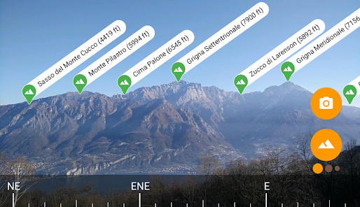
Discover the names and locations of mountain and hills around you while hiking, climbing, skiing, trekking or enjoying your favorite outdoor activity. Test your mountain knowledge and share your pictures of stunning skyline views with your friends on social networks.
FEATURES
- Precisely identifies mountain peaks and hills in real-time.
- Works worldwide: from Alps, Himalayas, Rocky Mountains and Andes up to the smallest hills, anywhere on Earth.
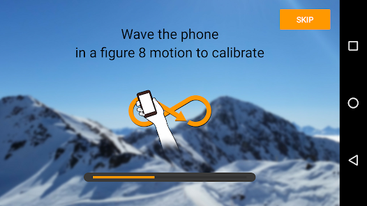
- Corrects GPS, compass, magnetometer and gyroscope errors with artificial intelligence.
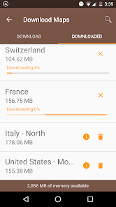
- Works online and offline with pre-downloaded maps.
- High quality photographs with peak names in overlay.
- Knows position, height and distance from you of more than 200.000 peaks.
- Works both with Imperial and Metric unit systems.
PeakLens is a novel Augmented Reality and Virtual Reality app for mountain lovers, hikers and trekkers. It is the result of years of research in artificial intelligence and computer vision, based on a novel algorithm that identifies mountain peaks in real time with high precision. Its core is a software component that compares what you actually see in the camera of your mobile phone or tablet with a virtual panorama, created from a digital 3D landscape model of the Earth. By matching what you see and the virtual panorama, PeakLens automatically corrects most errors that come from the imprecision of the compass and GPS sensor, giving you always the most accurate peak positioning.
RESOURCES
- Digital Elevation Model: the digital elevation model of the SRTM project (https://www2.jpl.nasa.gov/srtm) is used for calculating panoramic views.
- Peaks: the Peaks dataset is extracted from Openstreetmap.com.
OpenStreetMap is open data, licensed under the Open Data Commons Open Database License (ODbL).
PeakLens is a research result of Politecnico di Milano, Dipartimento di Elettronica, Informatica e Bioingegneria.
For any comments, questions or feedbacks contact us at info@peaklens.com!
Discover the names and locations of mountain and hills around you while hiking, climbing, skiing, trekking or enjoying your favorite outdoor activity. Test your mountain knowledge and share your pictures of stunning skyline views with your friends on social networks.
FEATURES
- Precisely identifies mountain peaks and hills in real-time.
- Works worldwide: from Alps, Himalayas, Rocky Mountains and Andes up to the smallest hills, anywhere on Earth.
- Corrects GPS, compass, magnetometer and gyroscope errors with artificial intelligence.
- Works online and offline with pre-downloaded maps.
- High quality photographs with peak names in overlay.
- Knows position, height and distance from you of more than 200.000 peaks.
- Works both with Imperial and Metric unit systems.
PeakLens is a novel Augmented Reality and Virtual Reality app for mountain lovers, hikers and trekkers. It is the result of years of research in artificial intelligence and computer vision, based on a novel algorithm that identifies mountain peaks in real time with high precision. Its core is a software component that compares what you actually see in the camera of your mobile phone or tablet with a virtual panorama, created from a digital 3D landscape model of the Earth. By matching what you see and the virtual panorama, PeakLens automatically corrects most errors that come from the imprecision of the compass and GPS sensor, giving you always the most accurate peak positioning.
RESOURCES
- Digital Elevation Model: the digital elevation model of the SRTM project (https://www2.jpl.nasa.gov/srtm) is used for calculating panoramic views.
- Peaks: the Peaks dataset is extracted from Openstreetmap.com.
OpenStreetMap is open data, licensed under the Open Data Commons Open Database License (ODbL).
PeakLens is a research result of Politecnico di Milano, Dipartimento di Elettronica, Informatica e Bioingegneria.
For any comments, questions or feedbacks contact us at info@peaklens.com!
Updated on
Safety starts with understanding how developers collect and share your data. Data privacy and security practices may vary based on your use, region, and age. The developer provided this information and may update it over time.


Ratings and reviews
2.7
2.27K reviews

A Google user
- Flag inappropriate
September 17, 2019
Great idea, but the app is far from perfect: * For offline mode, it requires too much permissions. I do not want to give it permission to access my photos and other files. The app could have stored the data in /sdcard/Android/data, which is possible even without storage permission. * The AI finds peaks even in a room. That would be OK (and expected) for compass-based detection, but it “finds” and moves all the peaks after a while. This does not look very reliable.
40 people found this review helpful

Simon Cripps
- Flag inappropriate
April 19, 2025
I've read some poor reviews and I don't agree. It's fast and accurate for me. Lost one star because I live in Tenerife, and neither Tenerife or the Canary Isles are included in the long list of downloadable areas. Hopefully it's included in Spain, but it's nowhere near Spain. Add it to the list please!

Katie JCMercyGrace
- Flag inappropriate
June 13, 2025
Both Husband and I installed this on our phones a Pixel 3axl and Pixel 7 pro. It's a junk! It can't find Denali in Alaska, at a turnout with a sign just in front of me pointing to Denali and three other peaks in view. I found only one called Igloo peak and that wasn't listed on the NPS sign. I guess you get what you pay for. This app is free and gives you nothing.
1 person found this review helpful
What’s new
Minor improvements and bug correction
App support
About the developer
Politecnico di Milano - DEIB
info@peaklens.com
Via Giuseppe Ponzio, 34
20133 Milano
Italy
+39 02 2399 3640


