ALTLAS: Trails, Maps & Hike
Contains adsIn-app purchases
4.3star
3.92K reviews
500K+
Downloads

Everyone
info


About this app
ALTLAS: Trail Navigation & Activity Tracker
Your ultimate companion for outdoor adventures. Navigate trails with precision, track activities comprehensively, and explore new paths with advanced GPS technology and detailed mapping tools.
KEY FEATURES
Advanced Navigation
Track your outdoor activities with professional-grade GPS accuracy and comprehensive trail mapping. Whether you're hiking mountain peaks or cycling through city streets, ALTLAS provides the precision you need.
Comprehensive Activity Support
Record and analyze your hiking, cycling, skiing, and walking adventures with detailed statistics and performance insights.
Rich Trail Database
Access thousands of user-shared routes and contribute your own discoveries to help the outdoor community explore safely.
Dual-Mode Altimeter
Experience accurate elevation tracking both indoors and outdoors with our innovative dual-mode system, combining GPS and barometric sensors for maximum precision.
CORE CAPABILITIES
Navigation & Tracking
• Professional GPS positioning with smart altitude correction
• Real-time activity statistics and performance metrics
• GPX file import and export for route sharing
• Live location sharing for coordination
Mapping & Visualization
• Multiple map types: topographic, satellite (Pro only), OpenStreetMap, and more.
• Offline map support for remote adventures (Pro only)
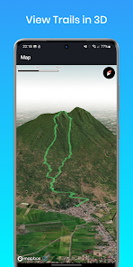
• 3D trail visualization for better route understanding (Pro only)
• Comprehensive route planning
Planning Tools
• Intelligent routing between multiple waypoints
• ETA calculator for trip planning
• Vertical distance measurement for elevation gain tracking
• Coordinate finder for precise location marking
Smart Technology
• Compass
• Dark mode for low-light conditions
• Weather forecasting integration
PERFECT FOR EVERY ADVENTURE
Hiking & Trekking: Navigate mountain trails with confidence using precise elevation data and topographic maps.
Cycling: Track road cycling and mountain biking with detailed performance metrics and route optimization.
Winter Sports: Monitor skiing and snowboarding activities with accurate altitude and speed tracking.
Urban Exploration: Discover walking tours and city adventures with comprehensive mapping tools.
PREMIUM FEATURES
Unlock advanced capabilities with ALTLAS Pro:
• Complete offline map access for remote adventures
• Stunning 3D trail visualization
• Premium satellite and specialized map layers
• Live location sharing for safety and coordination
TECHNICAL EXCELLENCE
GPS Mode: Utilizes high-precision satellite positioning with intelligent correction algorithms for optimal accuracy in outdoor environments.
Barometer Mode: Leverages device sensors for reliable altitude tracking indoors and in challenging GPS conditions.
SUPPORT & COMMUNITY
Join thousands of outdoor enthusiasts in our active community:
• Comprehensive Support Guide: https://altlas-app.com/support.html
• Direct Support: erol1apps@gmail.com
• Official Website: www.altlas-app.com
PRIVACY & SAFETY
ALTLAS respects your privacy and provides tools to enhance your safety outdoors. Location data is processed locally on your device, and sharing features are entirely optional.
Use of this application is at your own discretion and risk. Always carry appropriate safety equipment and inform others of your planned activities.
Ready to elevate your outdoor adventures? Download ALTLAS today and discover why outdoor enthusiasts worldwide trust our navigation technology.
Rate and review ALTLAS to help other adventurers discover the power of professional trail navigation.
Your ultimate companion for outdoor adventures. Navigate trails with precision, track activities comprehensively, and explore new paths with advanced GPS technology and detailed mapping tools.
KEY FEATURES
Advanced Navigation
Track your outdoor activities with professional-grade GPS accuracy and comprehensive trail mapping. Whether you're hiking mountain peaks or cycling through city streets, ALTLAS provides the precision you need.
Comprehensive Activity Support
Record and analyze your hiking, cycling, skiing, and walking adventures with detailed statistics and performance insights.
Rich Trail Database
Access thousands of user-shared routes and contribute your own discoveries to help the outdoor community explore safely.
Dual-Mode Altimeter
Experience accurate elevation tracking both indoors and outdoors with our innovative dual-mode system, combining GPS and barometric sensors for maximum precision.
CORE CAPABILITIES
Navigation & Tracking
• Professional GPS positioning with smart altitude correction
• Real-time activity statistics and performance metrics
• GPX file import and export for route sharing
• Live location sharing for coordination
Mapping & Visualization
• Multiple map types: topographic, satellite (Pro only), OpenStreetMap, and more.
• Offline map support for remote adventures (Pro only)
• 3D trail visualization for better route understanding (Pro only)
• Comprehensive route planning
Planning Tools
• Intelligent routing between multiple waypoints
• ETA calculator for trip planning
• Vertical distance measurement for elevation gain tracking
• Coordinate finder for precise location marking
Smart Technology
• Compass
• Dark mode for low-light conditions
• Weather forecasting integration
PERFECT FOR EVERY ADVENTURE
Hiking & Trekking: Navigate mountain trails with confidence using precise elevation data and topographic maps.
Cycling: Track road cycling and mountain biking with detailed performance metrics and route optimization.
Winter Sports: Monitor skiing and snowboarding activities with accurate altitude and speed tracking.
Urban Exploration: Discover walking tours and city adventures with comprehensive mapping tools.
PREMIUM FEATURES
Unlock advanced capabilities with ALTLAS Pro:
• Complete offline map access for remote adventures
• Stunning 3D trail visualization
• Premium satellite and specialized map layers
• Live location sharing for safety and coordination
TECHNICAL EXCELLENCE
GPS Mode: Utilizes high-precision satellite positioning with intelligent correction algorithms for optimal accuracy in outdoor environments.
Barometer Mode: Leverages device sensors for reliable altitude tracking indoors and in challenging GPS conditions.
SUPPORT & COMMUNITY
Join thousands of outdoor enthusiasts in our active community:
• Comprehensive Support Guide: https://altlas-app.com/support.html
• Direct Support: erol1apps@gmail.com
• Official Website: www.altlas-app.com
PRIVACY & SAFETY
ALTLAS respects your privacy and provides tools to enhance your safety outdoors. Location data is processed locally on your device, and sharing features are entirely optional.
Use of this application is at your own discretion and risk. Always carry appropriate safety equipment and inform others of your planned activities.
Ready to elevate your outdoor adventures? Download ALTLAS today and discover why outdoor enthusiasts worldwide trust our navigation technology.
Rate and review ALTLAS to help other adventurers discover the power of professional trail navigation.
Updated on
Safety starts with understanding how developers collect and share your data. Data privacy and security practices may vary based on your use, region, and age. The developer provided this information and may update it over time.


Ratings and reviews
4.4
3.84K reviews

Saibal Ray
- Flag inappropriate
July 4, 2020
This app is useful when going on treks on high altitudes. There is both a free and a pro version. The free version is perfectly usable. I have not tried out the app much. Indoors, it shows the elevation as 8m above mean sea level, which is accurate. The app uses GPS to find out the elevation the user is at and so is much more accurate than watches which use atmospheric pressure readings to deduce the altitude. The next time I go to the mountains or hop on a plane, I will try out the app and validate its accuracy in a more defined manner. The app also has compass support and can save way points across a trail which can later be used to backtrack your path. Overall, a very good app. If it works as described in field conditions. I am going to purchase the pro version to support the developer.
39 people found this review helpful
Erol1Apps
July 5, 2020
Thanks for your great feedback. If you have any suggestions or questions, please feel free to contact us at erol1apps@gmail.com.

Larry Versaw
- Flag inappropriate
December 28, 2020
(Based on 15+ hiking trips this past summer.) Gives fairly accurate reading on first opening the app. But after I switch to use another app and then come back to this app, it sometimes updates, but usually does not. It has been off as much as 900 feet, and stuck at the same reading for several minutes while I'm climbing or descending rapidly. So... very misleading at times. I finally found another Altimeter app that is simpler to understand and updates correctly.
32 people found this review helpful
Erol1Apps
February 14, 2021
Hello Larry,
We are sorry we didn't meet your expectations.
We've just published an update to the app with bug fixes and more.
for your last issue, if the accuracy of the GPS (+- sign under the altitude) is red so the app will now update the altitude until it's orange/green again.
You can contact us at erol1apps@gmail.com to get help.

Michael Gut
- Flag inappropriate
December 23, 2023
I liked this app, one of the best for hiking. Unfortunately, it also aids "interested parties" use my data for "legitimate interest". It is possible to disable this by scrolling through I don't know how many buttons and switch them off. Do you honestly think I will go through that charade every time I use the app? Right, I thought so. Therefore uninstalled.
7 people found this review helpful
Erol1Apps
December 23, 2023
We understand how annoying that must be. We're working on a solution. We hope you'll re-consider the rating once we fix the issue.
Update: we added an option to cancel it with a button.
What’s new
Introducing the brand-new Main Map, redesigned for the perfect outdoor experience
Added landscape mode support - try it out!
User profile sync is now live: your recorded trails stay synced across all your devices
General UI improvements for a smoother experience
Various bug fixes and performance enhancements
Added landscape mode support - try it out!
User profile sync is now live: your recorded trails stay synced across all your devices
General UI improvements for a smoother experience
Various bug fixes and performance enhancements
App support
About the developer
Tal Vaknin
vaknintal1@gmail.com
רוקח 92
דירה 4
רמת גן, 5257416
Israel


