Tracklia: GPX, KML, KMZ & maps
Contains adsIn-app purchases

4.3star
7.2K reviews
100K+
Downloads

Everyone
info
About this app
TRACKLIA will make your GPX and KML/KMZ mapping work easier! Plan new trips, edit previous, record new and share with the world!
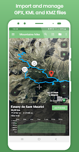
WORK WITH GPX, KML and KMZ files
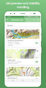
- Import tracks, routes and waypoints from GPX, KML and KMZ files (you can select what to import from your GPX / KML / KMZ file, no need to import everything)
- Record your own GPS tracks
- Get elevation graph, distance and ascent/descent of imported tracks and routes
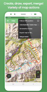
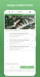
- Merge multiple tracks into one with interactive merger! Useful for Strava, Endomondo and other sport trackers users!
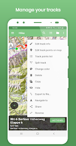
- Split one long track into parts
- Reverse track
- Share tracks and waypoints directly to the other apps (Like Google Maps or other navigation apps)
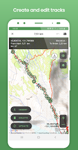
- GPX, KML and KMZ files edit:
- Add / update / delete / insert points in tracks and routes
- Delete multiple points at once
- Rename / change description for tracks and routes
- Delete tracks and waypoints from GPX, KML and KMZ file
- Update waypoints location, name and description
- Change waypoint icons
- GPX and KML files create / update :
- Create new track
- Add new waypoint
- Export updated or newly created tracks, routes and waypoints to *GPX* or *KML* file
- Export track or route data to *CSV file*
- Draw on map with your finger tip and send as an image.
MANAGE GPX DATA
TRACKLIA lets you to group and store your GPX, KML and KMZ data in app memory (My Maps list function).
You can import several GPX, KML or KMZ files to one map, edit and have it for your next trip! And the best - you can share your created trip with your friends as GPX or KML file!
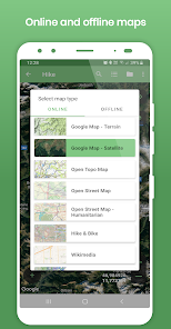
VARIETY OF MAPS
Offline maps:
- Open Street Map
Online maps:
- Google Maps - Normal
- Google Maps - Terrain
- Google Maps - Satellite
- Open Street Map
- Open Street Map - Humanitarian
- Open Topo Map
- Hike & Bike
- Wikimedia
- CyclOSM
- Stamen - Terrain
- Stamen - Toner
- Esri - Aerial
And many more to come!
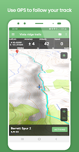
NAVIGATE YOUR TRIP
- Show current GPS position on map
- Follow GPS position continuously by adjusting map position
- Rotate map according GPS bearing
- See GPS position details (coordinates, accuracy, altitude, speed)
- Use offline maps while navigating
With these functions, TRACKLIA can be used as simple navigation tool.
Languages:
- Deutsch
- English
- Español
- Français
- हिन्दी
- Indonesia
- Português
- Русский
- Türkçe
- Tiếng Việt
If you are looking for tool to import GPX, KML or KMZ files, get GPS stats, edit GPX / KML / KMZ files, create GPX or KML files, update GPX / KML / KMZ files or simple navigation - TRACKLIA is for you!
If you have any questions, suggestions or if you want to help us to translate this app into more languages, please contact us via e-mail tracklia.app@gmail.com or from application menu selecting "Contact us"
WORK WITH GPX, KML and KMZ files
- Import tracks, routes and waypoints from GPX, KML and KMZ files (you can select what to import from your GPX / KML / KMZ file, no need to import everything)
- Record your own GPS tracks
- Get elevation graph, distance and ascent/descent of imported tracks and routes
- Merge multiple tracks into one with interactive merger! Useful for Strava, Endomondo and other sport trackers users!
- Split one long track into parts
- Reverse track
- Share tracks and waypoints directly to the other apps (Like Google Maps or other navigation apps)
- GPX, KML and KMZ files edit:
- Add / update / delete / insert points in tracks and routes
- Delete multiple points at once
- Rename / change description for tracks and routes
- Delete tracks and waypoints from GPX, KML and KMZ file
- Update waypoints location, name and description
- Change waypoint icons
- GPX and KML files create / update :
- Create new track
- Add new waypoint
- Export updated or newly created tracks, routes and waypoints to *GPX* or *KML* file
- Export track or route data to *CSV file*
- Draw on map with your finger tip and send as an image.
MANAGE GPX DATA
TRACKLIA lets you to group and store your GPX, KML and KMZ data in app memory (My Maps list function).
You can import several GPX, KML or KMZ files to one map, edit and have it for your next trip! And the best - you can share your created trip with your friends as GPX or KML file!
VARIETY OF MAPS
Offline maps:
- Open Street Map
Online maps:
- Google Maps - Normal
- Google Maps - Terrain
- Google Maps - Satellite
- Open Street Map
- Open Street Map - Humanitarian
- Open Topo Map
- Hike & Bike
- Wikimedia
- CyclOSM
- Stamen - Terrain
- Stamen - Toner
- Esri - Aerial
And many more to come!
NAVIGATE YOUR TRIP
- Show current GPS position on map
- Follow GPS position continuously by adjusting map position
- Rotate map according GPS bearing
- See GPS position details (coordinates, accuracy, altitude, speed)
- Use offline maps while navigating
With these functions, TRACKLIA can be used as simple navigation tool.
Languages:
- Deutsch
- English
- Español
- Français
- हिन्दी
- Indonesia
- Português
- Русский
- Türkçe
- Tiếng Việt
If you are looking for tool to import GPX, KML or KMZ files, get GPS stats, edit GPX / KML / KMZ files, create GPX or KML files, update GPX / KML / KMZ files or simple navigation - TRACKLIA is for you!
If you have any questions, suggestions or if you want to help us to translate this app into more languages, please contact us via e-mail tracklia.app@gmail.com or from application menu selecting "Contact us"
Updated on
Safety starts with understanding how developers collect and share your data. Data privacy and security practices may vary based on your use, region and age The developer provided this information and may update it over time.

No data shared with third parties
Learn more about how developers declare sharing

This app may collect these data types
App activity and App info and performance

Data is encrypted in transit

Data can’t be deleted
Ratings and reviews
4.2
6.95K reviews

Green AI
- Flag inappropriate
- Show review history
19 February 2024
I use Google Satellite view in Google My Maps to draw lines of "unexploxed" countryside dirt paths I want to explore. Though I can load My Maps in Google Maps, but in numerous occassions it didn't because I had no cell service in those areas. So now, I just exported the KMZ in My Maps and use Tracklia to see those lines/paths that I drew. I can also record my actual gps tracks to help others who might be interested to explore those paths in the future.
3 people found this review helpful

Arun Raj
- Flag inappropriate
- Show review history
30 October 2023
Based in my use for three days. Great app without a busy and confusing UI. Reasonable pricing for full version. Have not bought it yet, but seriously considering. -Would like the buttons on the side in landscape to may be 25% bigger, Current location on map to something bigger and more visible color/icon will be helpful while on road.
5 people found this review helpful

J Marshall
- Flag inappropriate
10 February 2024
I am a volunteer health walk leader and use Tracklia Pro regularly to log our walks. It also allows me to pass the gpx files to our admin team to let them correct errors in the "paper"route guidance documents. If I forget to stop recording at the end of a walk, I can edit the extra stuff off the file, many points at once (pro). If you use the lite version its one point edit at a time. A great and useful app even if the learning curve is a bit steep. Well worth the Pro fee if used regularly.
2 people found this review helpful
What's new
- Heart Rate data support in GPX files (import/merge/export)
- Show Heart Rate in track details chart
- Show track start/stop times
- Copy current (map center) coordinates to clipboard on click
- Improved GPX files export. Added support for additional schemas
- Show Heart Rate in track details chart
- Show track start/stop times
- Copy current (map center) coordinates to clipboard on click
- Improved GPX files export. Added support for additional schemas


