
GEOINCA Maps
100+
Downloads

Everyone
info
About this app
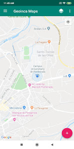
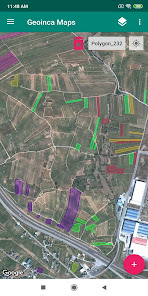
GEOINCA Maps is an application oriented to land management in agricultural and forestry environments that allows rapid visualization and capture of spatial data.
The main features or functionalities of GEOINCA Maps are:
- Project management and import to KML files.
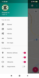
- Quick change of base map with options of orthophoto / orthophoto + cartography / relief / without map.
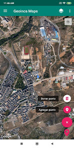
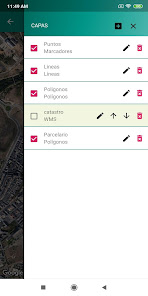
- Layer management:
* Creating layers of points, lines and polygons
* Erase layers and possibility to modify the display order
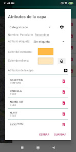
* Possibility to customize the colors of the different elements
* Possibility of adding text or numeric attributes
* Possibility of labeling entities based on attributes
* Possibility of categorizing entities based on attribute data
* Possibility to add custom WMS layers
- Connection with Google Maps
The main features or functionalities of GEOINCA Maps are:
- Project management and import to KML files.
- Quick change of base map with options of orthophoto / orthophoto + cartography / relief / without map.
- Layer management:
* Creating layers of points, lines and polygons
* Erase layers and possibility to modify the display order
* Possibility to customize the colors of the different elements
* Possibility of adding text or numeric attributes
* Possibility of labeling entities based on attributes
* Possibility of categorizing entities based on attribute data
* Possibility to add custom WMS layers
- Connection with Google Maps
Updated on
Safety starts with understanding how developers collect and share your data. Data privacy and security practices may vary based on your use, region, and age. The developer provided this information and may update it over time.

No data shared with third parties
Learn more about how developers declare sharing

No data collected
Learn more about how developers declare collection
What's new
1. Nueva función a la hora de exportar una capa en formato KML. Ahora permite compartir directamente desde la propia aplicación con las principales aplicaciones del móvil (gmail, google drive, whatsapp...)
2. Con la opción de "Borrar punto" activada ahora se permite borrar polígonos al pulsar sobre ellos.
3. Con la opción de "Borrar punto" activada ahora se permite borrar líneas al pulsar sobre ellas.
4. Corrección de errores.
2. Con la opción de "Borrar punto" activada ahora se permite borrar polígonos al pulsar sobre ellos.
3. Con la opción de "Borrar punto" activada ahora se permite borrar líneas al pulsar sobre ellas.
4. Corrección de errores.
App support
phone
Phone number
+34987442000


