
Outdooractive. Hike and Ride
Contains adsIn-app purchases
4.5star
50.6K reviewsinfo
1M+
Downloads

PEGI 3
info


About this app
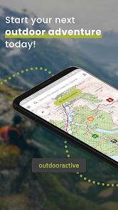
The Outdooractive App is the perfect GPS Tracker companion for hiking, cycling, biking, walking, running, and other outdoor activities. With the route planner app, you can find trails around Great Britain with ease and use our offline maps. Go Pro and get access to exclusive activity features like maps from Ordnance Survey® (os maps).
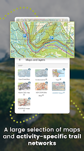
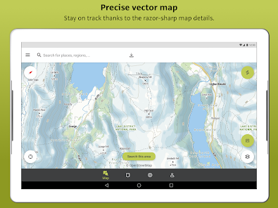
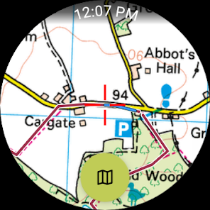
Excellent in-class outdoor activity maps:
Enjoy a high-resolution display of all offline maps and at all zoom levels thanks to our vector technology. Digital summer and winter layers are based on OpenStreetMap, and Pro and Pro+ members can also benefit from many other outdoor GPS tracker maps, such as the os maps from Ordnance Survey® . All of that is there to help you enjoy outdoor activity, like hiking, cycling, trekking, running, walking, biking, & mountain biking MTB any day of the year.
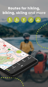
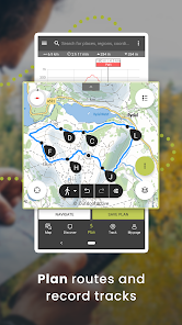
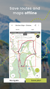
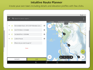
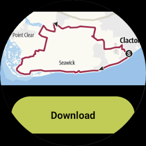
Outdoor Trail & Route Planner:
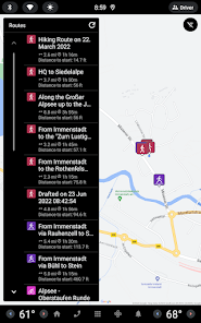
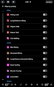
Easily use Route Planner and create all GPS Tracker trails based on your preferences. Add text and photos, publish them within the community or share them privately with friends. You can also import and export GPX files. You can use a route planner for all trails and for any activity, like cycling, trekking, hiking, walking, MTB or any other outdoor activity.
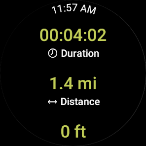
Recording your own TrackS & Trail:
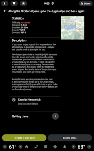
The GPS tracker allows you to record all tracks & Hiking trail to include duration, distance, altitudes, and an interactive altitude profile with outdoor GPS tracker.
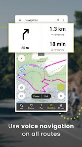
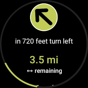
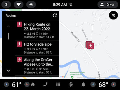
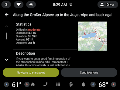
Navigation:
Navigation function with speech output lets you navigate comfortably from A to B on all trails & Hiking routes. Enjoy hiking, cycling, trekking, MTB routes & more with GPS tracker navigation with speech output.
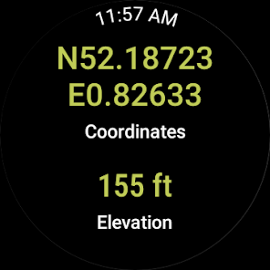
Smartwatches with WEAR OS from Google:
With a glance at your Smartwatch, you get information about your GPS position on the map. You can record tracks, get tracking data and navigate along routes. Use the app tile to easily access nearby routes.
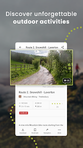
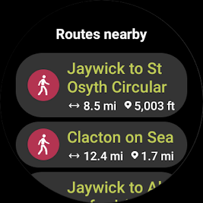
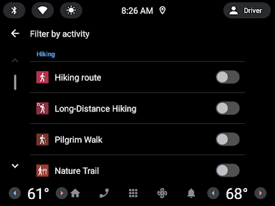
Global Trail Database:
Discover inspiring trail activity guides from tourism agencies and the community. Then, navigate with confidence and an outdoor GPS tracker on your next hike, run, cycling, trekking & walking routes, MTB, or outdoor activity adventure.
Outdoor Activity Challenges:
Join one of our walk, cycle, climb or run challenges. Pick your activity and choose the distance to complete this year.
Exclusively for Pro members
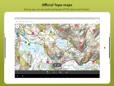
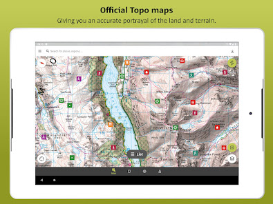
Add a Pro subscription and get all the latest offline maps from Ordnance Survey® (os maps), providing accurate information about hiking and cycling, trails, protected areas, and details about many other outdoor activities with an outdoor GPS tracker.
Go anywhere: Outdooractive Pro works offline maps without mobile and data signals. Access satellite imagery, and with unique Outdooractive offline maps, you’ll get over 30 activity trail networks and official topographic offline maps from across the world with the following providers:
Great Britain Ordnance Survey Landranger & Explorer (os maps); France IGN; Germany BKG; Austria BEV; Spain CNIG; Italy; Netherlands PDOK; Norway Kartverket; Switzerland swisstopo; Denmark Kortforsyningen; Sweden Lantmäteriet; Finland National Land Survey; New Zealand Land Information; Great Britain Ordnance Survey Landranger & Explorer (os maps), Utah USGS; Japan GSI and Global Map
BuddyBeacon:
Safety first: Share real-time GPS tracker location with all friends and family. Be safe and enjoy hiking, cycling, walking routes, trekking and more.
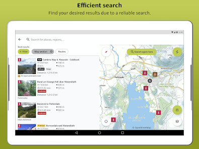
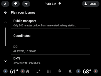
A Global Outdoor Travel Guide:
Helpful filters and powerful search functions help you not only find all Hiking trails but also places of interest, accommodation, and events. Global outdoor travel guide supports you while hiking, cycling, walking routes, trekking, gps tracker and more.
If you have questions or suggestions, please visit https://www.outdooractive.com/en/helpcenter/
Excellent in-class outdoor activity maps:
Enjoy a high-resolution display of all offline maps and at all zoom levels thanks to our vector technology. Digital summer and winter layers are based on OpenStreetMap, and Pro and Pro+ members can also benefit from many other outdoor GPS tracker maps, such as the os maps from Ordnance Survey® . All of that is there to help you enjoy outdoor activity, like hiking, cycling, trekking, running, walking, biking, & mountain biking MTB any day of the year.
Outdoor Trail & Route Planner:
Easily use Route Planner and create all GPS Tracker trails based on your preferences. Add text and photos, publish them within the community or share them privately with friends. You can also import and export GPX files. You can use a route planner for all trails and for any activity, like cycling, trekking, hiking, walking, MTB or any other outdoor activity.
Recording your own TrackS & Trail:
The GPS tracker allows you to record all tracks & Hiking trail to include duration, distance, altitudes, and an interactive altitude profile with outdoor GPS tracker.
Navigation:
Navigation function with speech output lets you navigate comfortably from A to B on all trails & Hiking routes. Enjoy hiking, cycling, trekking, MTB routes & more with GPS tracker navigation with speech output.
Smartwatches with WEAR OS from Google:
With a glance at your Smartwatch, you get information about your GPS position on the map. You can record tracks, get tracking data and navigate along routes. Use the app tile to easily access nearby routes.
Global Trail Database:
Discover inspiring trail activity guides from tourism agencies and the community. Then, navigate with confidence and an outdoor GPS tracker on your next hike, run, cycling, trekking & walking routes, MTB, or outdoor activity adventure.
Outdoor Activity Challenges:
Join one of our walk, cycle, climb or run challenges. Pick your activity and choose the distance to complete this year.
Exclusively for Pro members
Add a Pro subscription and get all the latest offline maps from Ordnance Survey® (os maps), providing accurate information about hiking and cycling, trails, protected areas, and details about many other outdoor activities with an outdoor GPS tracker.
Go anywhere: Outdooractive Pro works offline maps without mobile and data signals. Access satellite imagery, and with unique Outdooractive offline maps, you’ll get over 30 activity trail networks and official topographic offline maps from across the world with the following providers:
Great Britain Ordnance Survey Landranger & Explorer (os maps); France IGN; Germany BKG; Austria BEV; Spain CNIG; Italy; Netherlands PDOK; Norway Kartverket; Switzerland swisstopo; Denmark Kortforsyningen; Sweden Lantmäteriet; Finland National Land Survey; New Zealand Land Information; Great Britain Ordnance Survey Landranger & Explorer (os maps), Utah USGS; Japan GSI and Global Map
BuddyBeacon:
Safety first: Share real-time GPS tracker location with all friends and family. Be safe and enjoy hiking, cycling, walking routes, trekking and more.
A Global Outdoor Travel Guide:
Helpful filters and powerful search functions help you not only find all Hiking trails but also places of interest, accommodation, and events. Global outdoor travel guide supports you while hiking, cycling, walking routes, trekking, gps tracker and more.
If you have questions or suggestions, please visit https://www.outdooractive.com/en/helpcenter/
Updated on
Safety starts with understanding how developers collect and share your data. Data privacy and security practices may vary based on your use, region and age The developer provided this information and may update it over time.


Ratings and reviews
4.5
48.5K reviews

Jenny Gliddon
- Flag inappropriate
- Show review history
22 March 2023
Long time Viewranger customer. Very disappointed with the lack of functionality in this new app. Such a backwards step I'm now looking for an alternative even though it means I will lose all my tracks, routes and history since 2012. Edit: can no longer use other opensource maps, including in other countries. Viewranger even had piste maps! Also cannot share or link to the 3D version as before. Presumably now need to pay again to access what I used for years on Viewranger as a Pro subscriber.
8 people found this review helpful
Outdooractive AG
24 March 2023
Hi Jenny, Almost all that was in ViewRanger is in Outdooractive, but perhaps in a different place. Let us know what you are missing, to support@outdooractive.com, we may be able to tell you where to find it, or add it to our product request list.
3D and extra map styles are part of Pro, in ViewRanger they were part of the premium subscription too.

Ian Huyton
- Flag inappropriate
5 December 2021
Great route planning for different activities and the choice of map layers and overlays is great, but it's so disappointing that you are killing off Viewranger - I used to use both, but now can't buy or subscribe to new maps in Viewranger so have to use Outdoor Active for everything. While you've transferred the gimicky features of Viewranger we've lost a lot of basic functionality. 1. No +/- buttons for zoom. It sounds like a small thing, but pinch zoom is a nightmare with gloves or in the rain. 2. The line of a route or track is fat enough to cover the map detail underneath and there is no easy way to hide it to see if I'm supposed to be on a road, path or neither. Viewranger had a thinner line that could be easily toggled on or off to see the map detail. 3. Maps sometimes take forever to load, even on a fast connection - Viewranger seemed to have better servers. 4. I can't choose which topo map I want to use. If I'm close to a border then I get a strange patchwork of maps from the different countries making some scales unusable. This is a real problem in the Aosta region of Italy where I see a mix of Swiss, French and different Italian maps jigsawed together. 5. Viewranger gives UK grid references, this doesn't (or it didn't last time I was in the UK). 6. Viewranger makes it easy to find the altitude of any point, this only shows the altitude at my current location. If you could reproduce these features of Viewranger this would be the perfect outdoor navigation app, but as it is it leaves me and many others craving the app we've lost.
2 people found this review helpful
Outdooractive AG
10 December 2021
Hi Ian.
Thank you so much for the detailed review. We are aware of the demand for some of these features and continue to invest a lot of time and energy towards producing an app that we are proud of - If you have anything more to share with the team, please contact us at service@outdooractive.com.
All the best,
The Outdooractive team

Blue
- Flag inappropriate
18 September 2021
Extremely disappointing. Features that were free in viewranger are now premium. This might be ok if the app was an improvement, but it's actually significantly worse. The only free map is terrible and not being able to see multiple routes on it makes day to day planning on hiking trips (comparing routes...) a pain. You don't get your altitude on the homepage map either. I noticed a lot of platitudes in the replies to other reviews. I just want IGN maps back on Viewranger, or I'll look elsewhere
26 people found this review helpful
Outdooractive AG
20 September 2021
Thank you very much for your review. The new platform is being created with you in mind and the process is ongoing. The ViewRanger community brings a wealth of experience and it is feedback such as yours that helps us shape the app and strive to improve. We hope you will continue to join us on this exciting journey. The Outdooractive Team.
What's new
With this exciting update we have made it easier to record tracks and turn them into the great memories you'll be proud to share with friends & family!
Are you someone who loves to hike, cycle & run? Swapping between track activities has been made simpler for you.
Pick the statistics that you want to see during track recording with our customizable display.
Not sure what to name your track? No problem! We will help you with suggested names.


