
Outdooractive:徒步和骑行路线,GPS和导航
包含广告应用内购商品
4.6star
5.06万条评价info
100万+
次下载

PEGI 3
info


关于此应用
为智能手机、平板和Wear OS研发的Outdooractive App是在举行徒步、骑行、登山和其他户外运动时最好的伙伴。在App里你可以既简单又轻松的在全球范围内搜索和计划路线。
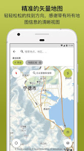
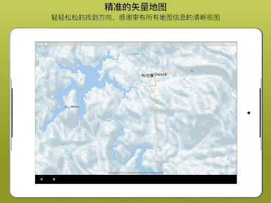
最新的矢量地图不仅可以为你提供关于徒步和骑行路线、飞拉达、保护区的精准信息还可以提供很多其他户外活动的资料。
全球路网数据库:
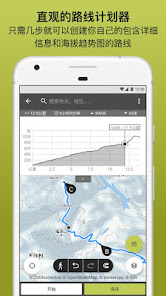
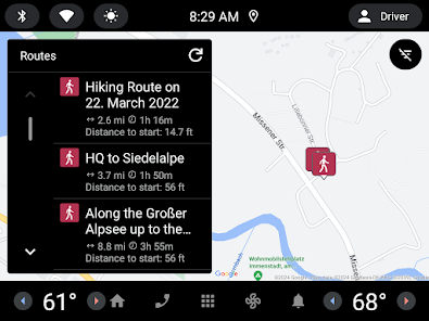
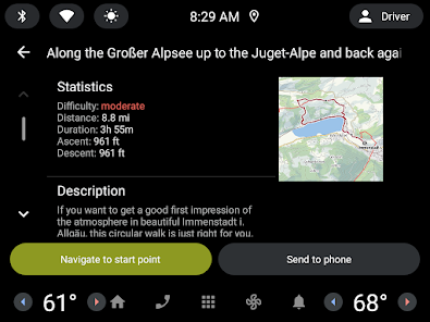
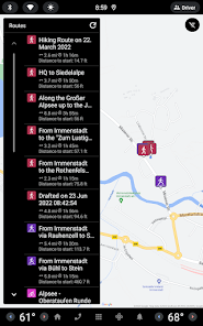
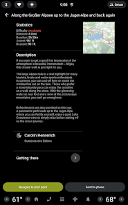
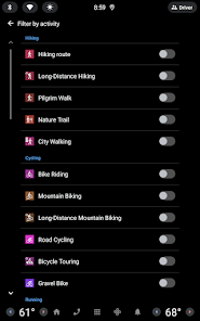
在数不胜数的徒步、骑行和滑雪推荐路线中搜索你喜欢的路线。所有路线都会提供完整的信息、海拔趋势图、图片和方向。
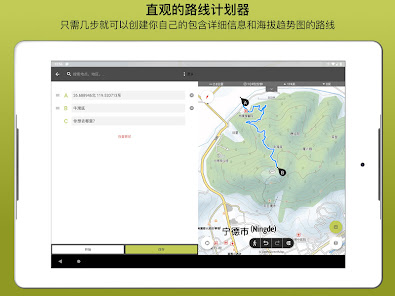
户外路线计划器:
我们的路线计划器可以让你既简单又轻松的根据你的个人偏好来创建和计划路线。你可以为它们添加文案和照片,发表至社群中或仅分享给你的朋友们。如有需要你也可以导出和导入GPX文件。
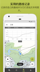
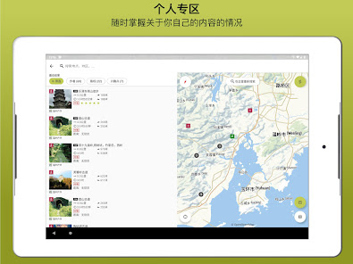
记录自己的路线:
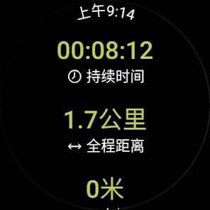
通过路线记录功能可让你记录包含持续时间、路线长度、海拔和互动型海拔趋势图的路线。
使用Google WEAR OS的智能手表:
在Standalone模式下使用你保存在手表中的地图,这样便不用携带手机了。记录路径并将它们上传至你的账号中。在离网情况下也可使用。
挑战:
参加一个徒步、骑行、攀爬或跑步挑战。选择你的运动并设置今年想完成的运动量。
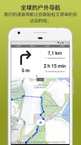
导航:
语音导航功能可以让你在所有路线上非常轻松的到达目的地。
BuddyBeacon:
安全第一:将你的实时位置分享给你的家人和朋友们。
最先进的地图科技:
感谢最先进的矢量地图技术你可以在所有的缩放级别查看所有的高清地图视图。我们的夏季和冬季地图使用的是OpenStreetMap地图。Pro和Pro+用户可以额外的使用其他更多的地图。
全球旅游指南:
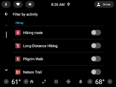
我们的筛选器和强大的搜索功能不仅能够帮你找到喜欢的路线,还可以找到景点、住处、活动和滑雪场。
山中小屋目录:
可在我们的山中小屋目录中找到欧洲大部分山中小屋的开放时间、空闲床位数量、价格和其他信息。目录与德国登山俱乐部(German Alpine Association DAV)、奥地利登山俱乐部(Austrian Alpine Association ÖAV)和南蒂罗尔登山俱乐部(Alpine Association for South Tyrol AVS)合作创建。
Pro会员专享
没有地域限制:Outdooractive Pro可在没有移动和联网信号的情况下离线使用。可以无上限的创建列表和使用没有广告的App。还可以观看卫星图像,包含30多种户外活动路网的Outdooractive地图和以下专业公司提供的官方拓扑地图:
Japan GSI
Great Britain Ordnance Survey, Landranger, Explorer
Germany BKG
Italy Edizione il Lupo, 4Land和其他
Spain CNIG
France IGN
Sweden Lantmäteriet
Switzerland swisstopo
Norway Kartverket
Austria BEV
Netherlands PDOK
Denmark Kortforsyningen
New Zealand Land Information
Finland National Land Survey
Utah USGS
Global Map
Pro+会员专享
Pro+会员除了可以使用登山俱乐部提供的官方地图外还可以使用KOMPASS的高级地图和KOMPASS、Schall Verlag、ADAC徒步指南(ADAC Wanderführer)的高级路线。
如果你有任何的问题或意见请访问https://www.outdooractive.com/en/helpcenter/
最新的矢量地图不仅可以为你提供关于徒步和骑行路线、飞拉达、保护区的精准信息还可以提供很多其他户外活动的资料。
全球路网数据库:
在数不胜数的徒步、骑行和滑雪推荐路线中搜索你喜欢的路线。所有路线都会提供完整的信息、海拔趋势图、图片和方向。
户外路线计划器:
我们的路线计划器可以让你既简单又轻松的根据你的个人偏好来创建和计划路线。你可以为它们添加文案和照片,发表至社群中或仅分享给你的朋友们。如有需要你也可以导出和导入GPX文件。
记录自己的路线:
通过路线记录功能可让你记录包含持续时间、路线长度、海拔和互动型海拔趋势图的路线。
使用Google WEAR OS的智能手表:
在Standalone模式下使用你保存在手表中的地图,这样便不用携带手机了。记录路径并将它们上传至你的账号中。在离网情况下也可使用。
挑战:
参加一个徒步、骑行、攀爬或跑步挑战。选择你的运动并设置今年想完成的运动量。
导航:
语音导航功能可以让你在所有路线上非常轻松的到达目的地。
BuddyBeacon:
安全第一:将你的实时位置分享给你的家人和朋友们。
最先进的地图科技:
感谢最先进的矢量地图技术你可以在所有的缩放级别查看所有的高清地图视图。我们的夏季和冬季地图使用的是OpenStreetMap地图。Pro和Pro+用户可以额外的使用其他更多的地图。
全球旅游指南:
我们的筛选器和强大的搜索功能不仅能够帮你找到喜欢的路线,还可以找到景点、住处、活动和滑雪场。
山中小屋目录:
可在我们的山中小屋目录中找到欧洲大部分山中小屋的开放时间、空闲床位数量、价格和其他信息。目录与德国登山俱乐部(German Alpine Association DAV)、奥地利登山俱乐部(Austrian Alpine Association ÖAV)和南蒂罗尔登山俱乐部(Alpine Association for South Tyrol AVS)合作创建。
Pro会员专享
没有地域限制:Outdooractive Pro可在没有移动和联网信号的情况下离线使用。可以无上限的创建列表和使用没有广告的App。还可以观看卫星图像,包含30多种户外活动路网的Outdooractive地图和以下专业公司提供的官方拓扑地图:
Japan GSI
Great Britain Ordnance Survey, Landranger, Explorer
Germany BKG
Italy Edizione il Lupo, 4Land和其他
Spain CNIG
France IGN
Sweden Lantmäteriet
Switzerland swisstopo
Norway Kartverket
Austria BEV
Netherlands PDOK
Denmark Kortforsyningen
New Zealand Land Information
Finland National Land Survey
Utah USGS
Global Map
Pro+会员专享
Pro+会员除了可以使用登山俱乐部提供的官方地图外还可以使用KOMPASS的高级地图和KOMPASS、Schall Verlag、ADAC徒步指南(ADAC Wanderführer)的高级路线。
如果你有任何的问题或意见请访问https://www.outdooractive.com/en/helpcenter/
更新日期


评分和评价
4.5
4.85万条评价

Вымпел Немов
- 举报不当评价
2022年1月3日
无法与ViewRanger账号同步,需另外注册付费账户才可以。
3 人认为该评价有用
Outdooractive AG
2022年1月10日
Hello and thankyou for your review. You can contact us directly at service@outdooractive.com. A member of our support team will be on hand to help.
We look forward to hearing from you, The Outdooractive team.

Pan Doris
- 举报不当评价
2022年12月26日
这个app经常会无故帮我打紧急电话,太可怕了
1 人认为该评价有用
Outdooractive AG
2022年12月31日
Please contact us at service@outdooractive.com so that we collect device and app details and investigate this issue. Thanks. The outdooractive Team.

Chun Lin
- 举报不当评价
- 显示评价记录
2022年5月16日
I was "forced" onto Outdooractive as ViewRanger was closed and I wanted to keep my tracks stored in ViewRanger. Although I could log in to the new app with my ViewRanger account to access my data, my first impressions about the new app aren't great. Firstly, I didn't remember seeing so many intrusive ads in ViewRanger as a free user - the ads in the new app are so dense and big for a mobile phone screen that they break up the UI (which is already confusing) and make me lost. Secondly, I've allowed the app to access my location, but in "Discovery - hiking", why do I only see routes in other countries far from mine? What's worse, I didn't find the feature to import a GPX file to create a route. Thirdly, when I browsed a previous track I recorded with ViewRanger, there are fewer graphs for the track stats - ViewRanger had useful visualisations for elevation and speed, but the new app only show one curve for elevation. I don't mean to be too critical, but based on the above, I really feel this new app focuses more on profit than functionality. [2022-05-16 EDIT] The developer suggested using the main Map to explore published routes. I tried but didn't find any - I used to find a lot around my area in ViewRanger - apparently they weren't migrated to the new app. It's a bit too obscure and complicated to import a GPX route via a separate file explorer - the suggested procedures almost seemed like those on a Windows computer. Nah, I'm keeping my current rating.
4 人认为该评价有用
Outdooractive AG
2022年5月16日
Hi Chun Lin, thank you for this feedback! To explore published routes use the main Map tab, tap Show Content at the top of the map, new routes will appear as you move the map. For GPX import, open the file using the file manager app or wherever it is saved, then direct it to open in Outdooractive. For more help contact support@outdooractive.com
新功能
在此版本中我们提高了App的性能并且修复了一些bugs。 你们有建议或者问题?那就将它发送到我们的邮箱 service@outdooractive.com
上吧 你们的Outdooractive团队


