
AlpineQuest Off-Road Explorer
4.5star
9.17K reviews
100K+
Downloads

Everyone
info

About this app
No advertisements ~ No data sharing & monetization ~ No analytics ~ No third party libraries
AlpineQuest is the complete solution for all outdoor activities and sports, including hiking, running, trailing, hunting, sailing, geocaching, off-road navigation and much more.
You can access and store locally a large range of on-line topographic maps, which will remain available even while being out of cell coverage. AlpineQuest also supports many on-board file-based raster map formats.
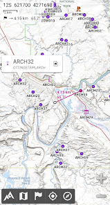
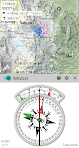
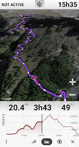
By using the GPS and the magnetic sensor of your device (with compass display), getting lost is part of the past: you are localized in real-time on the map, which can also be oriented to match where you are looking at.
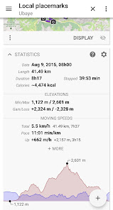
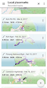
Save and retrieve unlimited placemarks, share them with your friends. Track your path, get advanced statistics and interactive graphics. You won’t have anymore questions about what you can accomplish.
By staying fully operational out of cell coverage (as often in mountain or abroad), AlpineQuest assists you in all your desires of deep wilderness exploring…
Don’t hesitate, try the free Lite version right now!
PLEASE report suggestions and issues on our dedicated forum https://www.alpinequest.net/forum (no registration needed, all questions answered) and not in comments.
Key features are:
★★ Maps ★★
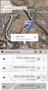
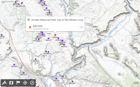
• Built-in online maps (with automatic local storage; road, topo and satellite maps included) and online layers (road names, hillshade, contours);
• Get more online maps and layers in one click from the included community maps list (all major worldwide maps and many local topo maps);
• Complete area storage of online maps for off-line use;
• On-board offline maps support (raster) including KMZ Overlays, OziExplorer OZFx2, OZFx3 (partly) and calibrated images, GeoTiff, GeoPackage GeoPkg, MbTile, SqliteDB and TMS zipped tiles (visit our website to get MOBAC, the free map creator);
• QuickChart Memory Map support (.qct maps only, .qc3 maps not compatible);
• Built-in image calibration tool to use any scan or picture as a map;
• Digital elevation model on-board storage (1-arcsec SRTM DEM) and support for HGT elevation files (both 1-arcsec and 3-arcsec resolutions) allowing display of terrain, hillshade and steep slopes;
• Polar maps (Arctic and Antarctic) support;
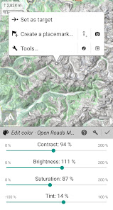
• Multiple maps in layers display, with per-map opacity/contrast/color/tint/blending control.
★★ Placemarks ★★
• Create, display, save, restore unlimited number of items (waypoints, routes, areas and tracks);
• Import/export GPX files, Google Earth KML/KMZ files and CSV/TSV files;
• Import ShapeFile SHP/PRJ/DBF, OziExplorer WPT/PLT, GeoJSON, IGC tracks, Geocaching LOC waypoints and export AutoCAD DXF files;
• Save and share online locations with other users using Community Placemarks;
• Details, advanced statistics and interactive graphics on various items;
• Time Controller to replay time-tagged tracks.
★★ GNSS Position / Orientation ★★
• On-map geolocation using device GNSS receivers (GPS/Glonass/Galileo/…) or Network;
• Map orientation, compass and target finder;
• Built-in GNSS/Barometric track recorder (long tracking capable, running in a separate and light process) with battery level and network strength recording;
• Proximity alerts and leave path alerts;
• Barometer support (compatible devices).
★★ And more ★★
• Metric, imperial, nautical and hybrid distance units;
• Latitude/Longitude and grid coordinate formats (WGS, UTM, MGRS, USNG, OSGB, SK42, Lambert, QTH, …) with on-map grids display;
• Ability to import hundreds of coordinate formats from https://www.spatialreference.org;
• …
AlpineQuest is the complete solution for all outdoor activities and sports, including hiking, running, trailing, hunting, sailing, geocaching, off-road navigation and much more.
You can access and store locally a large range of on-line topographic maps, which will remain available even while being out of cell coverage. AlpineQuest also supports many on-board file-based raster map formats.
By using the GPS and the magnetic sensor of your device (with compass display), getting lost is part of the past: you are localized in real-time on the map, which can also be oriented to match where you are looking at.
Save and retrieve unlimited placemarks, share them with your friends. Track your path, get advanced statistics and interactive graphics. You won’t have anymore questions about what you can accomplish.
By staying fully operational out of cell coverage (as often in mountain or abroad), AlpineQuest assists you in all your desires of deep wilderness exploring…
Don’t hesitate, try the free Lite version right now!
PLEASE report suggestions and issues on our dedicated forum https://www.alpinequest.net/forum (no registration needed, all questions answered) and not in comments.
Key features are:
★★ Maps ★★
• Built-in online maps (with automatic local storage; road, topo and satellite maps included) and online layers (road names, hillshade, contours);
• Get more online maps and layers in one click from the included community maps list (all major worldwide maps and many local topo maps);
• Complete area storage of online maps for off-line use;
• On-board offline maps support (raster) including KMZ Overlays, OziExplorer OZFx2, OZFx3 (partly) and calibrated images, GeoTiff, GeoPackage GeoPkg, MbTile, SqliteDB and TMS zipped tiles (visit our website to get MOBAC, the free map creator);
• QuickChart Memory Map support (.qct maps only, .qc3 maps not compatible);
• Built-in image calibration tool to use any scan or picture as a map;
• Digital elevation model on-board storage (1-arcsec SRTM DEM) and support for HGT elevation files (both 1-arcsec and 3-arcsec resolutions) allowing display of terrain, hillshade and steep slopes;
• Polar maps (Arctic and Antarctic) support;
• Multiple maps in layers display, with per-map opacity/contrast/color/tint/blending control.
★★ Placemarks ★★
• Create, display, save, restore unlimited number of items (waypoints, routes, areas and tracks);
• Import/export GPX files, Google Earth KML/KMZ files and CSV/TSV files;
• Import ShapeFile SHP/PRJ/DBF, OziExplorer WPT/PLT, GeoJSON, IGC tracks, Geocaching LOC waypoints and export AutoCAD DXF files;
• Save and share online locations with other users using Community Placemarks;
• Details, advanced statistics and interactive graphics on various items;
• Time Controller to replay time-tagged tracks.
★★ GNSS Position / Orientation ★★
• On-map geolocation using device GNSS receivers (GPS/Glonass/Galileo/…) or Network;
• Map orientation, compass and target finder;
• Built-in GNSS/Barometric track recorder (long tracking capable, running in a separate and light process) with battery level and network strength recording;
• Proximity alerts and leave path alerts;
• Barometer support (compatible devices).
★★ And more ★★
• Metric, imperial, nautical and hybrid distance units;
• Latitude/Longitude and grid coordinate formats (WGS, UTM, MGRS, USNG, OSGB, SK42, Lambert, QTH, …) with on-map grids display;
• Ability to import hundreds of coordinate formats from https://www.spatialreference.org;
• …
Updated on
Safety starts with understanding how developers collect and share your data. Data privacy and security practices may vary based on your use, region, and age. The developer provided this information and may update it over time.

No data shared with third parties
Learn more about how developers declare sharing

This app may collect these data types
Personal info

Data is encrypted in transit

You can request that data be deleted
Ratings and reviews
4.6
8.55K reviews

S S
- Flag inappropriate
December 5, 2023
In its various iterations, this has been one of the most consistently useful and valuable android apps I've ever used. It alone made owning a smartphone a worthwhile investment when I first purchased the pro version of the app years ago, and that appraisal remains equally apt today. Loads of useful maps available for use offline. Robust yet intuitive interface. Regular updates and functional improvements. And (hallelujah!) a one-time-purchase model at a very reasonable price point. Kudos!
184 people found this review helpful

A Google user
- Flag inappropriate
April 13, 2020
Fantastic app for bike packing, hiking, dual sport motorcycling. If you dig into the app you can plot trips beforehand telling you elevations between way points, mileage, insert highlighted areas anywhere. Maps are precise and accurate. Works great in airplane mode. Basically you are wherever the dot is and you can plot distances from there. I'm not a GPS geek I just want something that works, easy to use and is accurate. Could care less what Joe blow did and if he had a good time. 5 stars
44 people found this review helpful

Steve Leman
- Flag inappropriate
September 5, 2023
Works well, I am happy to have paid for the full version. Includes trail layers and ability to preplan a route, along with easy to download Japan GSI maps. There is a bit of a learning curve and I am not sure I have figured out how to use it optimally, but overall it suits me well. The real-time location saved me a couple times when I went off trail.
228 people found this review helpful
What's new
2.3.8
• Added ability to backup and restore all the application data into or from a single file;
• Added ability to display arrows, distances and ETE along the real-time location and compass heading lines (to be activated in the application settings);
• Added new slope unit (glide ratio);
• And more.
• Added ability to backup and restore all the application data into or from a single file;
• Added ability to display arrows, distances and ETE along the real-time location and compass heading lines (to be activated in the application settings);
• Added new slope unit (glide ratio);
• And more.


