
Nav Sensor Recorder

100+
Downloads

Everyone
info
About this app
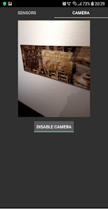
Nav Sensor Recorder is a free app that can capture images from camera and log measurements of smartphone's sensors and GNSS receiver.The app would be interesting to researchers, engineers and students who develop algorithms for navigation, localization, positioning, attitude determination, computer vision, and SLAM. Nav Sensor Recorder saves sensor data to CSV files which are easy to read and import. Images, captured by devices camera, are referenced to system time that can serve as a natural means of synchronization with IMU, GPS, and other sensors.
Nav Sensor Recorder does not show any advertisements.
The app currently supports the following sensors:
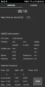
Accelerometer, gyroscope, magnetometer
Pressure sensor, light sensor, temperature sensor
GPS, i. e. latitude, longitude, height, speed, and heading of motion
Accuracy of GPS information, if available
GNSS raw observation, including broadcast navigation message (if supported by your phone)
The application stores collected data in the following folder:
Android\data\ru.navigation_expert.navsensorrecorder\files\yyyyMMdd_HHmmss\
yyyy, MM, dd, HH, mm, ss denote the year, month, day, hour, minute, and the second of the measurement start. Recorded .csv files are ordinary text files and can be opened by any text editor. Every line presents a new measurement. Values in lines are separated by a semicolon. The first value in every line is a system time in nanoseconds of the corresponding sensor data.
Note that starting from Android 11 default file managers on some devices may not have access to the folders with recorded data. In this case you can still access the data by connecting your device to a PC, or by using a 3rd party file manager. This inconvenience is caused by Google's new scoped storage policy preventing one app from accessing data of another app.
Navigation sensor data exchange format Version 0.0 is used to save JPEG images and GNSS raw observations to binary files with .nex extension.
To learn about .nex format please visit https://navigation-expert.com/nex_format
If you would like to get Matlab tools to quickly start processing your recorded raw GNSS observations, check out the Open Aided Navigation project repository:
https://bitbucket.org/oan/open-aided-navigation/src/master
Nav Sensor Recorder does not show any advertisements.
The app currently supports the following sensors:
Accelerometer, gyroscope, magnetometer
Pressure sensor, light sensor, temperature sensor
GPS, i. e. latitude, longitude, height, speed, and heading of motion
Accuracy of GPS information, if available
GNSS raw observation, including broadcast navigation message (if supported by your phone)
The application stores collected data in the following folder:
Android\data\ru.navigation_expert.navsensorrecorder\files\yyyyMMdd_HHmmss\
yyyy, MM, dd, HH, mm, ss denote the year, month, day, hour, minute, and the second of the measurement start. Recorded .csv files are ordinary text files and can be opened by any text editor. Every line presents a new measurement. Values in lines are separated by a semicolon. The first value in every line is a system time in nanoseconds of the corresponding sensor data.
Note that starting from Android 11 default file managers on some devices may not have access to the folders with recorded data. In this case you can still access the data by connecting your device to a PC, or by using a 3rd party file manager. This inconvenience is caused by Google's new scoped storage policy preventing one app from accessing data of another app.
Navigation sensor data exchange format Version 0.0 is used to save JPEG images and GNSS raw observations to binary files with .nex extension.
To learn about .nex format please visit https://navigation-expert.com/nex_format
If you would like to get Matlab tools to quickly start processing your recorded raw GNSS observations, check out the Open Aided Navigation project repository:
https://bitbucket.org/oan/open-aided-navigation/src/master
Updated on
Safety starts with understanding how developers collect and share your data. Data privacy and security practices may vary based on your use, region, and age. The developer provided this information and may update it over time.

No data shared with third parties
Learn more about how developers declare sharing

No data collected
Learn more about how developers declare collection


