

IGNrando' – France hiking maps
In-app purchases

3.4star
3.76K reviews
500K+
Downloads

Everyone
info


About this app
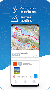
IGNrando’ is a collaborative platform for sharing routes and points of interest (POIs) related to outdoor activities in France.
RICH DATA OFFER
• Tens of thousands of routes and POIs all accross Metropolitan and Overseas France
• Choose the activity, difficulty level and route length to find routes around you or near any other place
• Download or mark as favorite the desired routes or POIs
MAPS & LAYERS IN FREE ACCESS (with internet connection)
• Plan IGN: most updated map, suitable for all activities
• Aerial photos (IGN)
• OpenStreetMap Outdoors: world map with hiking routes & contour lines
• OpenCycleMap: world map with cycling routes & contour lines
∙ Spain IGN map
∙ Swisstopo map
∙ Emergency calls (112) mobile network coverage map for France
∙ OpenSnowMap
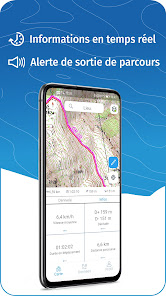
GPS GUIDING ALONG ROUTES
• See your progression on the altitude graph
• Get alerted if you exit the route
• Get notified of upcoming POIs or route info points (available soon)
GPS TRACKING AND DATA CREATION
• Record your own routes with GPS tracking
• Quickly create routes on-device with the automatic routing tool that follows roads and paths (online only, with subscription)
• Create Points of interest
• Send your routes to ignrando.fr for backup or to publish them
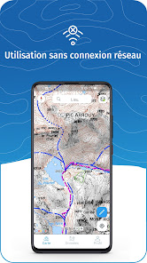
OFFLINE USE
• The GPS keeps working even without internet: see your position on the map, use GPS guiding and record routes
• Downloaded routes: descriptions, photos and guiding remain accessible
• Downloaded maps (with subscription)
Useful tip: Enabling Airplane Mode or disabling Mobile Data improves battery life, without affecting the Location Services (GPS)
IGN MAPS SUBSCRIPTION
• Create routes with pedestrian and vehicle routing
• View & download the following maps & layers:
∙ All free version maps
∙ IGN maps (various scales)
∙ IGN 1:25k topo maps (Top 25): the famous French topographical maps available at all zoom levels
∙ 1950 IGN maps
∙ Military maps (1820-1866)
∙ ICAO aeronautical charts
∙ France mobile network operators coverage maps
∙ Slopes > 30° (useful for winter activites)
∙ Cadastral parcels layer
∙ DFCI grid (forest fire protection grid)
• Drones flight restriction areas
∙ Roads & paths layer (only available with Aerial photos)
Play Store subscription
• Linked to Google account
• Automatic renewal unless cancelled at least 24 hours before the end of the current period
• Auto-renewal may be turned off after purchase
IGNrando' store subscription
• Linked to IGNrando' account
• No automatic renewal
• Can be used on 3 devices at the same time
Use an SD card to store your data
Free space on your device.
——————————————————————
Got ideas to improve the IGNrando' app
Write us on: ignrando@ubicarta.com
RICH DATA OFFER
• Tens of thousands of routes and POIs all accross Metropolitan and Overseas France
• Choose the activity, difficulty level and route length to find routes around you or near any other place
• Download or mark as favorite the desired routes or POIs
MAPS & LAYERS IN FREE ACCESS (with internet connection)
• Plan IGN: most updated map, suitable for all activities
• Aerial photos (IGN)
• OpenStreetMap Outdoors: world map with hiking routes & contour lines
• OpenCycleMap: world map with cycling routes & contour lines
∙ Spain IGN map
∙ Swisstopo map
∙ Emergency calls (112) mobile network coverage map for France
∙ OpenSnowMap
GPS GUIDING ALONG ROUTES
• See your progression on the altitude graph
• Get alerted if you exit the route
• Get notified of upcoming POIs or route info points (available soon)
GPS TRACKING AND DATA CREATION
• Record your own routes with GPS tracking
• Quickly create routes on-device with the automatic routing tool that follows roads and paths (online only, with subscription)
• Create Points of interest
• Send your routes to ignrando.fr for backup or to publish them
OFFLINE USE
• The GPS keeps working even without internet: see your position on the map, use GPS guiding and record routes
• Downloaded routes: descriptions, photos and guiding remain accessible
• Downloaded maps (with subscription)
Useful tip: Enabling Airplane Mode or disabling Mobile Data improves battery life, without affecting the Location Services (GPS)
IGN MAPS SUBSCRIPTION
• Create routes with pedestrian and vehicle routing
• View & download the following maps & layers:
∙ All free version maps
∙ IGN maps (various scales)
∙ IGN 1:25k topo maps (Top 25): the famous French topographical maps available at all zoom levels
∙ 1950 IGN maps
∙ Military maps (1820-1866)
∙ ICAO aeronautical charts
∙ France mobile network operators coverage maps
∙ Slopes > 30° (useful for winter activites)
∙ Cadastral parcels layer
∙ DFCI grid (forest fire protection grid)
• Drones flight restriction areas
∙ Roads & paths layer (only available with Aerial photos)
Play Store subscription
• Linked to Google account
• Automatic renewal unless cancelled at least 24 hours before the end of the current period
• Auto-renewal may be turned off after purchase
IGNrando' store subscription
• Linked to IGNrando' account
• No automatic renewal
• Can be used on 3 devices at the same time
Use an SD card to store your data
Free space on your device.
——————————————————————
Got ideas to improve the IGNrando' app
Write us on: ignrando@ubicarta.com
Updated on
Safety starts with understanding how developers collect and share your data. Data privacy and security practices may vary based on your use, region and age The developer provided this information and may update it over time.


Ratings and reviews
3.6
3.6K reviews

Frank Schweppe
- Flag inappropriate
- Show review history
4 December 2021
I used ViewRanger, which was an excellent app to get access to downloaded offline IGN maps (the whole social network buddy stuff does not interest me at all but that's OK, you don't need to use it). Unfortunately ViewRanger is no more, sold out to another app that is worse. IGN Rando is the obvious one to use instead. Have downloaded it but use will be limited until the possibility to download maps on an SD card becomes available. For anyone designing ths kind of software, do realize that just where you need topo maps, in the outdoors, connection to a 4G data network is often bad or non existent. So you really need preloaded maps of a fairly large area, and that is just too much data for the phone's internal memory (unless you have a very expensive phone with huge internal storage, and even then, if you also need to store pictures and videos etc. there, it still fills up). Keeping maps on an SD card is way better. Once it has that option I'll give it more stars...
19 people found this review helpful
Ubicarta
6 December 2021
Thank you for your message Frank.
Saving maps on an SD card is already available in the beta version of the app, and it will be available in the normal version by the end of the week. You can contact us at ignrando@ubicarta.com if needed. Kind regards.

Mathieu Louis
- Flag inappropriate
24 September 2021
Sluggish, crashes very often, very bad UI. After downloading the maps and using offline mode it takes forever to draw the map when zooming in. The only positive thing is the actual content of the official IGN maps, I wish this content was be available in a properly developed and designed app. I'm not confident relying on this app for navigation in remote mountains.
10 people found this review helpful

Robert Kovacs
- Flag inappropriate
11 September 2022
A great app when it works. 2 problems I have had.... 1 I cannot stop the route guidance once started. Only way was to restart the phone! 2 creating a route no longer traces the path to the roads or tracks and just does straight lines! I did pay for the subscription for the maps and the routing functionality but they need to be fixed please.
5 people found this review helpful
Ubicarta
18 December 2023
Avez-vous eu l'occasion de tester l'application récemment ? Nous avons apporté de nombreuses améliorations.
What's new
• Added "Winter routes" overlay
• Other recent changes:
- Added "Emergency calls (112)" and "My provider’s network" overlays
- Added zones forbidden for aerial photography (ZICAD) in the “Drone Restriction” overlay
- Changing the position of a point of interest by moving it on the map
- Added display of paper IGN maps in route description


