
OS Maps: Explore hiking trails
In-App-Käufe
3,1star
19.100 Rezensionen
1 Mio.+
Downloads

Jedes Alter
info


Über diese App
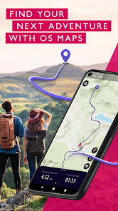
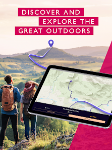
Explore the great outdoors the way you want, all while staying safe with OS Maps. Whether you want to hike, bike or run, OS Maps will guide you with amazing trails across the USA.
Want to find new places in your local neighbourhood? Or plan that next thru-hiking adventure? From breathtaking National Parks to easy walks along the coast, experience the thrill of finding a brand new trail that you never even knew existed with OS Maps. Why you’ll love using OS Maps:
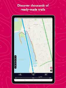
• EXPLORE NEW PLACES, CREATE NEW ADVENTURES
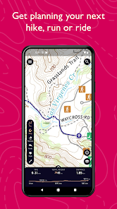
Plan unlimited trails with detailed, up to date maps across the country and discover that next great trail! Whether you love to hike, bike or run, there’s multiple map layers to suit any activity, including topographic and aerial maps.
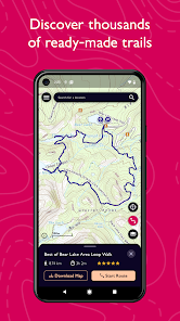
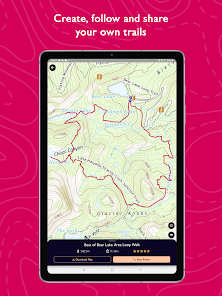
• TRAILS AT YOUR FINGERTIPS
Search for the best trails in an area as rated by fellow outdoor enthusiasts and plot your own trail to follow, share and record.
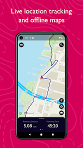
• VIEW & DOWNLOAD MAPS OFFLINE
No cell reception? No problem. Download your favorite areas to save and view offline – so you can view your maps and routes even without cell reception. Plus, you can export your favourite trails & routes to your GPX device.
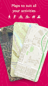
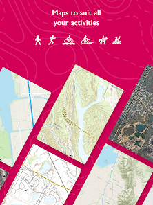
• TRAIL MAPS TO SUIT ANY ACTIVITY
Choose from multiple map layers; plan activities & find trails with detailed topographic mapping; or explore the landscape in stunning detail with aerial view. You can even see the world in 3D on desktop with 3D map layers.
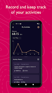
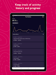
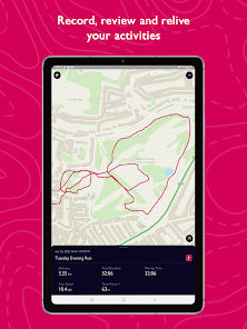
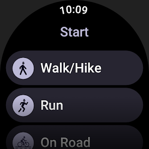
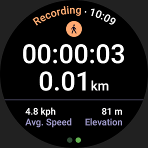
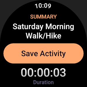
• RECORD, REVIEW & RELIVE ACTIVITIES
Use the activity tracking feature, and activity history dashboard to track each & every adventure. Look back on past activities & review your stats.
• STAY SAFE ON THE TRAIL
Live GPS location tracking and never miss a turn with off-course alerts will keep you on track. Download trails, routes and maps and share with others.
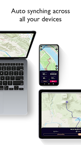
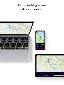
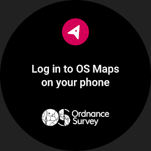
• USE ON EVERY DEVICE
Go from laptop to hilltop with ease! View, create & sync your routes & activities with a single account across multiple devices. Plan on desktop, follow & record your activities on mobile or compatible Wear OS devices.
• PLANNING MADE EASY
Use OS Maps as your off-road GPS tracker with automatic ‘snap-to-path’ making route planning easy with the shortest distance between your waypoints plotted automatically.
• UNLIMITED PRINTING
Print copies of trails and maps to take with you so you always have a backup to hand.
• USEFUL INFO
$4.99 for monthly subscriptions and $28.99 for annual subscriptions
Battery life can be dramatically decreased by using GPS constantly.
We release updates to all of our apps as we improve them, making them even more stable and adding extra features. Along the way, your feedback and comments about those apps are really important to us. If there’s an issue or something you’d like us to know, head to https://www.ordnancesurvey.co.uk/contact-us
OS Maps offers an auto-renewing monthly subscription and an auto-renewing yearly subscription to provide you with premium access to OS Maps while you maintain an active subscription. If you chose to purchase a premium subscription, your payment will be processed by Google.
Subscriptions may be managed through the Google Play App after purchase. Subscriptions on Google Play are renewed automatically unless you unsubscribe at least 24-hours before the end of the current period. Your Google account will be charged for renewal no more than 24 hours before to the end of the current period. You may cancel a subscription at any time before the end of the applicable billing period by going to your Subscriptions list on the Google Play App.
Terms and conditions: http://os.uk/termsosmaps
Privacy policy: http://os.uk/privacy
Want to find new places in your local neighbourhood? Or plan that next thru-hiking adventure? From breathtaking National Parks to easy walks along the coast, experience the thrill of finding a brand new trail that you never even knew existed with OS Maps. Why you’ll love using OS Maps:
• EXPLORE NEW PLACES, CREATE NEW ADVENTURES
Plan unlimited trails with detailed, up to date maps across the country and discover that next great trail! Whether you love to hike, bike or run, there’s multiple map layers to suit any activity, including topographic and aerial maps.
• TRAILS AT YOUR FINGERTIPS
Search for the best trails in an area as rated by fellow outdoor enthusiasts and plot your own trail to follow, share and record.
• VIEW & DOWNLOAD MAPS OFFLINE
No cell reception? No problem. Download your favorite areas to save and view offline – so you can view your maps and routes even without cell reception. Plus, you can export your favourite trails & routes to your GPX device.
• TRAIL MAPS TO SUIT ANY ACTIVITY
Choose from multiple map layers; plan activities & find trails with detailed topographic mapping; or explore the landscape in stunning detail with aerial view. You can even see the world in 3D on desktop with 3D map layers.
• RECORD, REVIEW & RELIVE ACTIVITIES
Use the activity tracking feature, and activity history dashboard to track each & every adventure. Look back on past activities & review your stats.
• STAY SAFE ON THE TRAIL
Live GPS location tracking and never miss a turn with off-course alerts will keep you on track. Download trails, routes and maps and share with others.
• USE ON EVERY DEVICE
Go from laptop to hilltop with ease! View, create & sync your routes & activities with a single account across multiple devices. Plan on desktop, follow & record your activities on mobile or compatible Wear OS devices.
• PLANNING MADE EASY
Use OS Maps as your off-road GPS tracker with automatic ‘snap-to-path’ making route planning easy with the shortest distance between your waypoints plotted automatically.
• UNLIMITED PRINTING
Print copies of trails and maps to take with you so you always have a backup to hand.
• USEFUL INFO
$4.99 for monthly subscriptions and $28.99 for annual subscriptions
Battery life can be dramatically decreased by using GPS constantly.
We release updates to all of our apps as we improve them, making them even more stable and adding extra features. Along the way, your feedback and comments about those apps are really important to us. If there’s an issue or something you’d like us to know, head to https://www.ordnancesurvey.co.uk/contact-us
OS Maps offers an auto-renewing monthly subscription and an auto-renewing yearly subscription to provide you with premium access to OS Maps while you maintain an active subscription. If you chose to purchase a premium subscription, your payment will be processed by Google.
Subscriptions may be managed through the Google Play App after purchase. Subscriptions on Google Play are renewed automatically unless you unsubscribe at least 24-hours before the end of the current period. Your Google account will be charged for renewal no more than 24 hours before to the end of the current period. You may cancel a subscription at any time before the end of the applicable billing period by going to your Subscriptions list on the Google Play App.
Terms and conditions: http://os.uk/termsosmaps
Privacy policy: http://os.uk/privacy
Aktualisiert am
Was die Sicherheit angeht, solltest du nachvollziehen, wie Entwickler deine Daten erheben und weitergeben. Die Datenschutz- und Sicherheitspraktiken können je nach Verwendung, Region und Alter des Nutzers variieren. Diese Informationen wurden vom Entwickler zur Verfügung gestellt und können jederzeit von ihm geändert werden.


Bewertungen und Rezensionen
3,1
17.900 Rezensionen

Helen Gillard
- Als unangemessen melden
10. Januar 2021
Simply great, easy to use. Great maps as usual with OS. Could show closed sections of paths to be even better, but great for walks.
1 Person fand diese Bewertung hilfreich
Ordnance Survey Ltd
11. Januar 2021
Hi Helen, thank you for your review, we are pleased you are enjoying OS Maps.

Dr Poldi
- Als unangemessen melden
10. Dezember 2020
Cannot connect to Google play
Ordnance Survey Ltd
11. Dezember 2020
Hi Dr Poldi, we are very keen to get you up and running on OS Maps. Can we suggest you try uninstalling and re-installing the app, then let us know if this solves the issue.

Ein Google-Nutzer
- Als unangemessen melden
- Rezensionsverlauf anzeigen
25. Februar 2019
Not able to start (app terminated while starting). Not in Germany and not in UK network. No issues with OS maps (they are brilliant) via viewranger. Update 2019-02-25: New version (2019-02-19), same result. Just not working. :(
3 Personen fanden diese Bewertung hilfreich
Ordnance Survey Ltd
25. Februar 2019
Sorry to hear you've had problems with the app; our last release was aimed at fixing crashes, so please do give it another go and we hope you'll see an improvement.
Neuigkeiten
This latest release includes improvements to performance and introduces a map scale which can be seen in the bottom left when viewing the map.


