
OS Maps: Explore hiking trails
Ilova ichida xaridlar
3,2star
19,7 ming ta sharh
1 mln+
Yuklanmalar

Hamma uchun
info


Bu ilova haqida
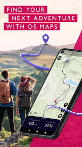
Explore the great outdoors the way you want, all while staying safe with OS Maps. Whether you want to hike, bike or run, OS Maps will guide you with amazing trails across the USA.
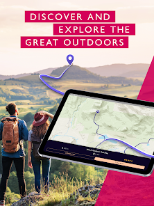
Want to find new places in your local neighbourhood? Or plan that next thru-hiking adventure? From breathtaking National Parks to easy walks along the coast, experience the thrill of finding a brand new trail that you never even knew existed with OS Maps. Why you’ll love using OS Maps:
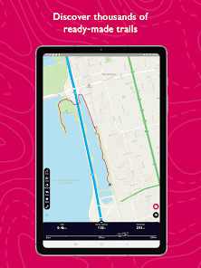
• EXPLORE NEW PLACES, CREATE NEW ADVENTURES
Plan unlimited trails with detailed, up to date maps across the country and discover that next great trail! Whether you love to hike, bike or run, there’s multiple map layers to suit any activity, including topographic and aerial maps.
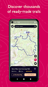
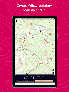
• TRAILS AT YOUR FINGERTIPS
Search for the best trails in an area as rated by fellow outdoor enthusiasts and plot your own trail to follow, share and record.
• VIEW & DOWNLOAD MAPS OFFLINE
No cell reception? No problem. Download your favorite areas to save and view offline – so you can view your maps and routes even without cell reception. Plus, you can export your favourite trails & routes to your GPX device.
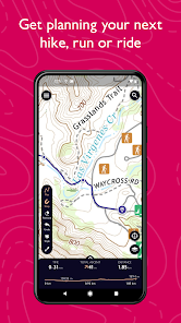
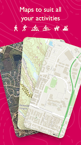
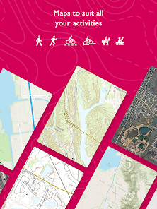
• TRAIL MAPS TO SUIT ANY ACTIVITY
Choose from multiple map layers; plan activities & find trails with detailed topographic mapping; or explore the landscape in stunning detail with aerial view. You can even see the world in 3D on desktop with 3D map layers.
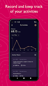
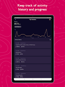
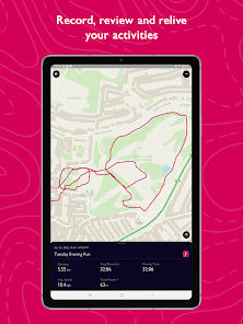
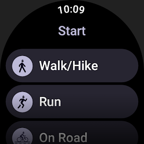
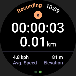
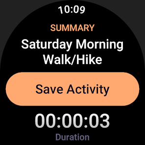
• RECORD, REVIEW & RELIVE ACTIVITIES
Use the activity tracking feature, and activity history dashboard to track each & every adventure. Look back on past activities & review your stats.
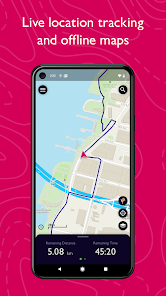
• STAY SAFE ON THE TRAIL
Live GPS location tracking and never miss a turn with off-course alerts will keep you on track. Download trails, routes and maps and share with others.
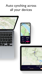
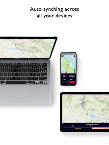
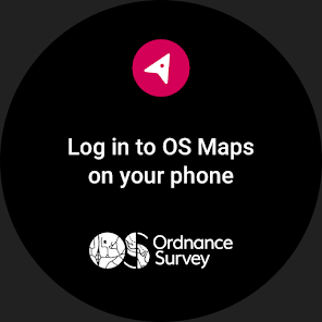
• USE ON EVERY DEVICE
Go from laptop to hilltop with ease! View, create & sync your routes & activities with a single account across multiple devices. Plan on desktop, follow & record your activities on mobile or compatible Wear OS devices.
• PLANNING MADE EASY
Use OS Maps as your off-road GPS tracker with automatic ‘snap-to-path’ making route planning easy with the shortest distance between your waypoints plotted automatically.
• UNLIMITED PRINTING
Print copies of trails and maps to take with you so you always have a backup to hand.
• USEFUL INFO
$4.99 for monthly subscriptions and $28.99 for annual subscriptions
Battery life can be dramatically decreased by using GPS constantly.
We release updates to all of our apps as we improve them, making them even more stable and adding extra features. Along the way, your feedback and comments about those apps are really important to us. If there’s an issue or something you’d like us to know, head to https://www.ordnancesurvey.co.uk/contact-us
OS Maps offers an auto-renewing monthly subscription and an auto-renewing yearly subscription to provide you with premium access to OS Maps while you maintain an active subscription. If you chose to purchase a premium subscription, your payment will be processed by Google.
Subscriptions may be managed through the Google Play App after purchase. Subscriptions on Google Play are renewed automatically unless you unsubscribe at least 24-hours before the end of the current period. Your Google account will be charged for renewal no more than 24 hours before to the end of the current period. You may cancel a subscription at any time before the end of the applicable billing period by going to your Subscriptions list on the Google Play App.
Terms and conditions: http://os.uk/termsosmaps
Privacy policy: http://os.uk/privacy
Want to find new places in your local neighbourhood? Or plan that next thru-hiking adventure? From breathtaking National Parks to easy walks along the coast, experience the thrill of finding a brand new trail that you never even knew existed with OS Maps. Why you’ll love using OS Maps:
• EXPLORE NEW PLACES, CREATE NEW ADVENTURES
Plan unlimited trails with detailed, up to date maps across the country and discover that next great trail! Whether you love to hike, bike or run, there’s multiple map layers to suit any activity, including topographic and aerial maps.
• TRAILS AT YOUR FINGERTIPS
Search for the best trails in an area as rated by fellow outdoor enthusiasts and plot your own trail to follow, share and record.
• VIEW & DOWNLOAD MAPS OFFLINE
No cell reception? No problem. Download your favorite areas to save and view offline – so you can view your maps and routes even without cell reception. Plus, you can export your favourite trails & routes to your GPX device.
• TRAIL MAPS TO SUIT ANY ACTIVITY
Choose from multiple map layers; plan activities & find trails with detailed topographic mapping; or explore the landscape in stunning detail with aerial view. You can even see the world in 3D on desktop with 3D map layers.
• RECORD, REVIEW & RELIVE ACTIVITIES
Use the activity tracking feature, and activity history dashboard to track each & every adventure. Look back on past activities & review your stats.
• STAY SAFE ON THE TRAIL
Live GPS location tracking and never miss a turn with off-course alerts will keep you on track. Download trails, routes and maps and share with others.
• USE ON EVERY DEVICE
Go from laptop to hilltop with ease! View, create & sync your routes & activities with a single account across multiple devices. Plan on desktop, follow & record your activities on mobile or compatible Wear OS devices.
• PLANNING MADE EASY
Use OS Maps as your off-road GPS tracker with automatic ‘snap-to-path’ making route planning easy with the shortest distance between your waypoints plotted automatically.
• UNLIMITED PRINTING
Print copies of trails and maps to take with you so you always have a backup to hand.
• USEFUL INFO
$4.99 for monthly subscriptions and $28.99 for annual subscriptions
Battery life can be dramatically decreased by using GPS constantly.
We release updates to all of our apps as we improve them, making them even more stable and adding extra features. Along the way, your feedback and comments about those apps are really important to us. If there’s an issue or something you’d like us to know, head to https://www.ordnancesurvey.co.uk/contact-us
OS Maps offers an auto-renewing monthly subscription and an auto-renewing yearly subscription to provide you with premium access to OS Maps while you maintain an active subscription. If you chose to purchase a premium subscription, your payment will be processed by Google.
Subscriptions may be managed through the Google Play App after purchase. Subscriptions on Google Play are renewed automatically unless you unsubscribe at least 24-hours before the end of the current period. Your Google account will be charged for renewal no more than 24 hours before to the end of the current period. You may cancel a subscription at any time before the end of the applicable billing period by going to your Subscriptions list on the Google Play App.
Terms and conditions: http://os.uk/termsosmaps
Privacy policy: http://os.uk/privacy
Oxirgi yangilanish
Xavfsizlik — dastur ishlab chiquvchilar maʼlumotlaringizni qanday jamlashi va ulashishini tushinishdan boshlanadi. Maʼlumotlar maxfiyligi va xavfsizlik amaliyotlari ilovadan foydalanish, hudud va yoshga qarab farq qilishi mumkin. Bu axborot dastur ishlab chiquvchi tomonidan taqdim etilgan va keyinchalik yangilanishi mumkin.

Bu ilova tashqi hamkorlarga quyidagi turdagi maʼlumotlarini ulashishi mumkin
Ilova tarixi va Ilova axboroti va unumdorlik

Ushbu ilova quyidagi axborot turlarini toʻplashi mumkin
Joylashuv, Salomatlik va fitnes va yana 2 ta

Maʼlumotlar uzatish vaqtida shifrlanadi

Maʼlumotlarni oʻchirishni soʻrashingiz mumkin
Reytinglar va sharhlar
3,2
18,5 ming ta sharh

Shukur Roziyev
- Nomaqbul deb belgilash
13-aprel, 2023
Zannnnnnamdaye mazami
Ordnance Survey Ltd
19-aprel, 2023
Thanks for the 5-star review!
Nima yangiliklar
This latest release includes improvements to performance and introduces a map scale which can be seen in the bottom left when viewing the map.


