Colorado Trail Explorer
4,2star
304 avis
100K+
Téléchargements

Tout public
info


À propos de l'application
Discover and explore Colorado’s unique trail experiences with the Colorado Trail Explorer (COTREX). Available for free and without ads, COTREX offers the most comprehensive official trail map in the state and is a collaborative effort spanning over 230 trail managers.
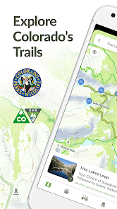
View trails by allowed uses on the map, browse featured routes, download offline maps, view closures, alerts, wildfire boundaries and avalanche forecasts, record trips and notes in the field, and share your experiences with the community. COTREX is your gateway into Colorado’s magnificent outdoors.
■ DISCOVER TRAILS & FEATURED ROUTES
Browse or search to find trails and recommendations from experts that match your activities or interests.
Change activity type to dynamically filter trails on the map whether hiking, biking, riding, skiing, snowshoeing and more.
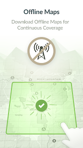
■ DOWNLOAD MAPS
No cell coverage? No problem! Download free maps ahead of time for a continuous experience that doesn’t depend on your network.
COTREX offline maps are lightweight in size and easy to download.
■ VIEW ADVISORIES, CLOSURES, AND CONDITIONS FROM OFFICIAL SOURCES
More land managers use COTREX than any other app in Colorado to show their real-time closures and advisories. Know when and where a trail is closed before you leave the house, review real-time wildfire updates, and see daily avalanche forecasts all straight from the experts.
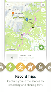
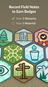
■ PLAN AND RECORD YOUR TRIPS
Measure the distance and elevation profile for any trail segment quickly and easily to plan your next trip.
Capture the details of your outdoor experiences by recording Trips.
■ SHARE WITH THE COMMUNITY
Inform and inspire the entire COTREX community by sharing your Trips and Field Notes publicly or submitting Trip Reports.
By sharing your experiences, you also help to inform trail managers about current conditions on the ground.
■ ABOUT COTREX
Colorado Trail Explorer aims to map every official trail in the state of Colorado. COTREX connects people, trails, and technology by coordinating the efforts of federal, state, county, and local agencies to create a comprehensive repository of recreational trails for public use.
COTREX is unique in that the app only shows information from official sources. No unreliable crowdsourced information or recommendations from someone on the other side of the country. Everything you see in COTREX has been reviewed and approved by the managers and experts local to that area.
This project is led by Colorado Parks and Wildlife (CPW) and Department of Natural Resources, but is only made possible through partnerships with organizations at every level statewide. COTREX represents a seamless network of trails managed by over 230 land managers.
■ DISCLAIMERS
[Battery Life] We do everything we can to make the app low power when recording, but GPS is notorious for reducing battery life.
Terms: https://trails.colorado.gov/terms
Privacy Policy: https://trails.colorado.gov/privacy
View trails by allowed uses on the map, browse featured routes, download offline maps, view closures, alerts, wildfire boundaries and avalanche forecasts, record trips and notes in the field, and share your experiences with the community. COTREX is your gateway into Colorado’s magnificent outdoors.
■ DISCOVER TRAILS & FEATURED ROUTES
Browse or search to find trails and recommendations from experts that match your activities or interests.
Change activity type to dynamically filter trails on the map whether hiking, biking, riding, skiing, snowshoeing and more.
■ DOWNLOAD MAPS
No cell coverage? No problem! Download free maps ahead of time for a continuous experience that doesn’t depend on your network.
COTREX offline maps are lightweight in size and easy to download.
■ VIEW ADVISORIES, CLOSURES, AND CONDITIONS FROM OFFICIAL SOURCES
More land managers use COTREX than any other app in Colorado to show their real-time closures and advisories. Know when and where a trail is closed before you leave the house, review real-time wildfire updates, and see daily avalanche forecasts all straight from the experts.
■ PLAN AND RECORD YOUR TRIPS
Measure the distance and elevation profile for any trail segment quickly and easily to plan your next trip.
Capture the details of your outdoor experiences by recording Trips.
■ SHARE WITH THE COMMUNITY
Inform and inspire the entire COTREX community by sharing your Trips and Field Notes publicly or submitting Trip Reports.
By sharing your experiences, you also help to inform trail managers about current conditions on the ground.
■ ABOUT COTREX
Colorado Trail Explorer aims to map every official trail in the state of Colorado. COTREX connects people, trails, and technology by coordinating the efforts of federal, state, county, and local agencies to create a comprehensive repository of recreational trails for public use.
COTREX is unique in that the app only shows information from official sources. No unreliable crowdsourced information or recommendations from someone on the other side of the country. Everything you see in COTREX has been reviewed and approved by the managers and experts local to that area.
This project is led by Colorado Parks and Wildlife (CPW) and Department of Natural Resources, but is only made possible through partnerships with organizations at every level statewide. COTREX represents a seamless network of trails managed by over 230 land managers.
■ DISCLAIMERS
[Battery Life] We do everything we can to make the app low power when recording, but GPS is notorious for reducing battery life.
Terms: https://trails.colorado.gov/terms
Privacy Policy: https://trails.colorado.gov/privacy
Date de mise à jour
La sécurité, c'est d'abord comprendre comment les développeurs collectent et partagent vos données. Les pratiques concernant leur confidentialité et leur protection peuvent varier selon votre utilisation, votre région et votre âge. Le développeur a fourni ces informations et peut les modifier ultérieurement.

Aucune donnée partagée avec des tiers
En savoir plus sur la manière dont les développeurs déclarent le partage

Cette appli peut recueillir ces types de données
Position, Informations personnelles et 3 autres

Les données sont chiffrées lors de leur transfert

Vous pouvez demander la suppression des données
Notes et avis
4,2
290 avis
Nouveautés
The map now shows restricted areas for snowmobiles when in snowmobile mode
Assistance de l'appli
À propos du développeur
The Governor's Office of Information Technology
myColorado@state.co.us
1575 N Sherman St Ste 5
Denver, CO 80203-1702
United States
+1 303-562-9855


