GnssLogger App
4.4star
367 reviews
50K+
Downloads

Everyone
info


About this app
GnssLogger by Google enables in-depth analysis and logging of all types of location and sensor data such as GPS (Global Positioning System), network location and other sensor data. GnssLogger is available for phones and watches. It comes with the following features for phones:
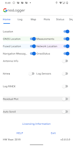
HOME TAB:
● Control various data logging such as raw GNSS measurements, GnssStatus, NMEA, navigation messages, sensor data and RINEX logs.
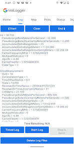
LOG TAB:
● View all location and raw measurement data.
● Control offline logging using 'Start Log', 'Stop & Send' and 'Timed Log'.
● Enable specific items to be logged using corresponding switches in Home Tab.
● Delete existing log files from disk.
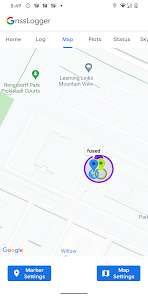
MAP TAB:
● Visualize on GoogleMap, the location provided by GPS chipset, Network Location Provider (NLP), Fused Location Provider (FLP), and computed Weighted Least Square (WLS) position.
● Toggle between different map views and location types.
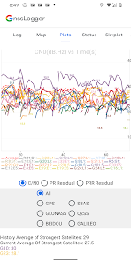
PLOTS TAB:
● Visualize CN0 (Signal Strength), PR (pseudorange) Residual and PRR (pseudorange rate) Residual vs time.
STATUS TAB:
● View detailed information of all visible GNSS (Global Navigation Satellite System) satellites such as GPS, Beidou (BDS), QZSS, GAL (Galileo), GLO (GLONASS) and IRNSS.
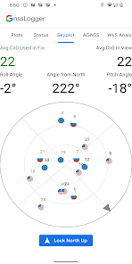
SKYPLOT TAB:
● Visualize the data of all visible GNSS satellites using a skyplot.
● View the average CN0 of all the satellites in view and the ones used in fix.
AGNSS TAB:
● Experiment with Assisted-GNSS functionalities.
WLS Analysis TAB:
● View the Weighted Least Square position, velocity and their uncertainties computed based on raw GNSS measurements.
● Compare the WLS results to the GNSS chipset reported values.
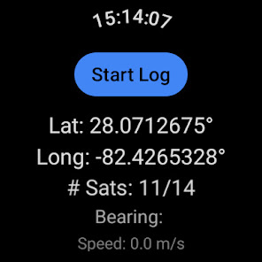
It comes with the following features for watches running Wear OS 3.0 and higher:
● View real-time GNSS chipset status information.
● Log various GNSS and sensor data to CSV and RINEX files.
HOME TAB:
● Control various data logging such as raw GNSS measurements, GnssStatus, NMEA, navigation messages, sensor data and RINEX logs.
LOG TAB:
● View all location and raw measurement data.
● Control offline logging using 'Start Log', 'Stop & Send' and 'Timed Log'.
● Enable specific items to be logged using corresponding switches in Home Tab.
● Delete existing log files from disk.
MAP TAB:
● Visualize on GoogleMap, the location provided by GPS chipset, Network Location Provider (NLP), Fused Location Provider (FLP), and computed Weighted Least Square (WLS) position.
● Toggle between different map views and location types.
PLOTS TAB:
● Visualize CN0 (Signal Strength), PR (pseudorange) Residual and PRR (pseudorange rate) Residual vs time.
STATUS TAB:
● View detailed information of all visible GNSS (Global Navigation Satellite System) satellites such as GPS, Beidou (BDS), QZSS, GAL (Galileo), GLO (GLONASS) and IRNSS.
SKYPLOT TAB:
● Visualize the data of all visible GNSS satellites using a skyplot.
● View the average CN0 of all the satellites in view and the ones used in fix.
AGNSS TAB:
● Experiment with Assisted-GNSS functionalities.
WLS Analysis TAB:
● View the Weighted Least Square position, velocity and their uncertainties computed based on raw GNSS measurements.
● Compare the WLS results to the GNSS chipset reported values.
It comes with the following features for watches running Wear OS 3.0 and higher:
● View real-time GNSS chipset status information.
● Log various GNSS and sensor data to CSV and RINEX files.
Updated on
Safety starts with understanding how developers collect and share your data. Data privacy and security practices may vary based on your use, region, and age. The developer provided this information and may update it over time.

No data shared with third parties
Learn more about how developers declare sharing

No data collected
Learn more about how developers declare collection
Ratings and reviews
4.4
349 reviews

Owen Watson
- Flag inappropriate
- Show review history
November 30, 2025
It's a real PITA to get the data into Google Earth. To process the RINEX output get RTKLIB_EX_2.5.0 and mostly use the command-line options as the GUI versions are ROUGH. edit: crashes consistently when saving and sending logs. aagh!!!
1 person found this review helpful
Developed with Google
January 28, 2026
Sorry you're having problems! The simplest path to Google Earth is probably NMEA->KML converters you can find online. If that doesn't work for you, could you contact us at pseudoranges-feedback@google.com so that we can work together to figure it out?

JohnnyJim J
- Flag inappropriate
May 17, 2025
Incredibly feature-rich app in an incredibly small package. VERY accurate GPS positioning, altitude and compass! I just wish my Google Pixel 9 Pro XL could use its engine for storing picture GPS location instead of the camera's built-in engine, which is extremely inaccurate (it wanders all over the place and can be off by hundreds of feet even outside)
2 people found this review helpful

Andrew Mercer
- Flag inappropriate
January 2, 2026
lots of data that fails to export. The app gets stuck in "preparing your data"
Developed with Google
January 28, 2026
Hi, we would like to fix this. Can you please write to us at pseudoranges-feedback@google.com so that we can help you better?
What’s new
• Log game rotation vector sensor - Uses accelerometer and gyroscope for orientation (no magnetometer, so reference is not north).
• Settings screen on watch - Turn on and off various settings similar to the phone app.
• Map screen on watch - Shows real-time chipset GNSS position on map.
• Settings screen on watch - Turn on and off various settings similar to the phone app.
• Map screen on watch - Shows real-time chipset GNSS position on map.
App support
About the developer
Google LLC
support@google.com
1600 Amphitheatre Pkwy
Mountain View, CA 94043-1351
United States
+1 650-253-0000


