
ArcGIS Earth
4.0star
1.04K reviews
100K+
Downloads

Everyone
info


About this app
ArcGIS Earth is a native application available on iOS, Android, and Windows platforms. It enables users to access content, tools, and analysis from anywhere, whether it's online or offline. ArcGIS Earth is designed for everyone and provides user-friendly 3D experiences. It's also consistent between the desktop and mobile environments and adaptable to many collaborative scenarios.
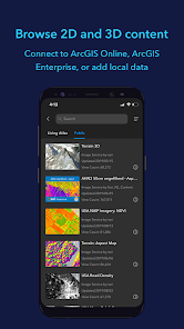
Data support
ArcGIS Earth allows you to use a variety of items from ArcGIS Online, ArcGIS Enterprise, local data, and web services:
• Browse web scenes, map services, image services, scene services, and feature services.
• Browse local files including mobile scene packages (MSPK), KML, KMZ, tile packages, and scene layer packages (SLPK).
• Support has been added for Living Atlas of the World.
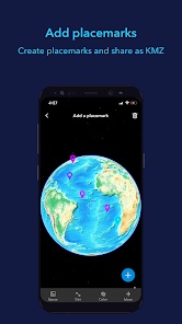
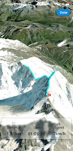
Key features
• Connect to ArcGIS Online or ArcGIS Enterprise.
• Tap to identify features.
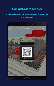
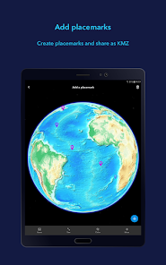
• Support has been added for collecting, editing, and sharing placemarks.
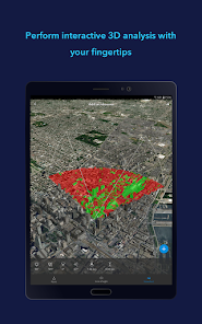
• Interactive analysis tools include Measure, Line of Sight, and Viewshed.
• Create and share tours with geotagged photos.
• Search for places and switch locators.
• Start-up tips and guidance for hand gestures are included.
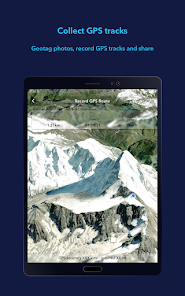
• Record and preview GPS tracks, and share with your organization.
Data support
ArcGIS Earth allows you to use a variety of items from ArcGIS Online, ArcGIS Enterprise, local data, and web services:
• Browse web scenes, map services, image services, scene services, and feature services.
• Browse local files including mobile scene packages (MSPK), KML, KMZ, tile packages, and scene layer packages (SLPK).
• Support has been added for Living Atlas of the World.
Key features
• Connect to ArcGIS Online or ArcGIS Enterprise.
• Tap to identify features.
• Support has been added for collecting, editing, and sharing placemarks.
• Interactive analysis tools include Measure, Line of Sight, and Viewshed.
• Create and share tours with geotagged photos.
• Search for places and switch locators.
• Start-up tips and guidance for hand gestures are included.
• Record and preview GPS tracks, and share with your organization.
Updated on
Safety starts with understanding how developers collect and share your data. Data privacy and security practices may vary based on your use, region, and age. The developer provided this information and may update it over time.

No data shared with third parties
Learn more about how developers declare sharing

No data collected
Learn more about how developers declare collection
Ratings and reviews
4.0
1.01K reviews

Craig H
- Flag inappropriate
May 17, 2024
App barely functions on Android. Tried to search for a specific location wasn't even able to type the whole name in. Maybe ok on a PC or laptop definitely not ready for mobile unfortunately.

Jacob Bingham (UFTS)
- Flag inappropriate
April 2, 2024
Performs really terribly, even though it's 2D imagery, the base map brings my device to its knees (~3 fps) at max zoom, while Google Earth manages 20 fps with max detail, 3D imagery
1 person found this review helpful

A Google user
- Flag inappropriate
- Show review history
September 24, 2019
Needs still some improvement. Overall it's good to seem the 3d data to view and interact seamlessly. But after I added multiple datasets the basemap is not showing up anymore and all I can see is grdilines without the basemap even if i closed the app sign out. I could remove the datasets now and the basemap shows. However once the data is added from the organisation and if I sign out the data is still available showing info. It should remove the data layers if we sign out.
37 people found this review helpful
Esri
October 30, 2019
Hi Manish,
Thanks for using ArcGIS Earth. For the missing basemaps - if a web scene was added, then all layers in the globe including basemaps will be replaced. If this web scene has no basemaps, then you will see the gridlines. That's my best guess. We are aware of the other bug and are working towards fixing it.
Best,
ArcGIS Earth team
What's new
The following enhancements have been added for version 2.1:
• Support for viewing 3D tiles data from services and local files.
• Support for adding OGC GeoPackage from local files or downloading it from portal items. • Support for launching the ArcGIS Earth app from a universal link with parameters.
• Enhanced drawing editor with picture attachments.
• View and play slides embedded in a web scene.
App support
phone
Phone number
+19097932853


