
AlpineQuest Explorer Lite
4.6star
16.7K reviews
1M+
Downloads

Everyone
info

About this app
No advertisements ~ No data sharing & monetization ~ No analytics ~ No third party libraries
AlpineQuest is the complete solution for all outdoor activities and sports, including hiking, running, trailing, hunting, sailing, geocaching, off-road navigation and much more.
You can access and store locally a large range of on-line topographic maps, which will remain available even while being out of cell coverage. AlpineQuest also supports many on-board file-based raster map formats.
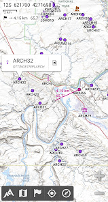
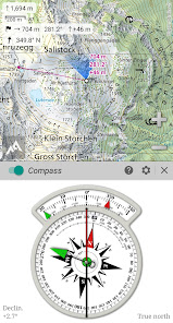
By using the GPS and the magnetic sensor of your device (with compass display), getting lost is part of the past: you are localized in real-time on the map, which can also be oriented to match where you are looking at.
Save and retrieve unlimited placemarks, share them with your friends. Track your path, get advanced statistics and interactive graphics. You won’t have anymore questions about what you can accomplish.
By staying fully operational out of cell coverage (as often in mountain or abroad), AlpineQuest assists you in all your desires of deep wilderness exploring…
Don’t hesitate, use this Lite version right now for free!
PLEASE report suggestions and issues on our dedicated forum https://www.alpinequest.net/forum (no registration needed, all questions answered) and not in comments.
Key features are (for full version):
★★ Maps ★★
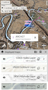
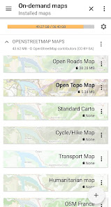
• Built-in online maps (with automatic local storage; road, topo and satellite maps included) and online layers (road names, hillshade, contours);
• Get more online maps and layers in one click from the included community maps list (all major worldwide maps and many local topo maps);
• Complete area storage of online maps for off-line use;
• On-board offline maps support (raster) including KMZ Overlays, OziExplorer OZFx2, OZFx3 (partly) and calibrated images, GeoTiff, GeoPackage GeoPkg, MbTile, SqliteDB and TMS zipped tiles (visit our website to get MOBAC, the free map creator);
• QuickChart Memory Map support (.qct maps only, .qc3 maps not compatible);
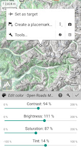
• Built-in image calibration tool to use any scan or picture as a map;
• Digital elevation model on-board storage (1-arcsec SRTM DEM) and support for HGT elevation files (both 1-arcsec and 3-arcsec resolutions) allowing display of terrain, hillshade and steep slopes;
• Polar maps (Arctic and Antarctic) support;
• Multiple maps in layers display, with per-map opacity/contrast/color/tint/blending control.
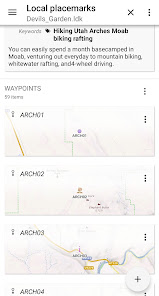
★★ Placemarks ★★
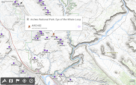
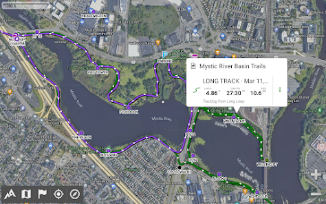
• Create, display, save, restore unlimited number of items (waypoints, routes, areas and tracks);
• Import/export GPX files, Google Earth KML/KMZ files and CSV/TSV files;
• Import ShapeFile SHP/PRJ/DBF, OziExplorer WPT/PLT, GeoJSON, IGC tracks, Geocaching LOC waypoints and export AutoCAD DXF files;
• Save and share online locations with other users using Community Placemarks;
• Details, advanced statistics and interactive graphics on various items;
• Time Controller to replay time-tagged tracks.
★★ GNSS Position / Orientation ★★
• On-map geolocation using device GNSS receivers (GPS/Glonass/Galileo/…) or Network;
• Map orientation, compass and target finder;
• Built-in GNSS/Barometric track recorder (long tracking capable, running in a separate and light process) with battery level and network strength recording;
• Proximity alerts and leave path alerts;
• Barometer support (compatible devices).
★★ And more ★★
• Metric, imperial, nautical and hybrid distance units;
• Latitude/Longitude and grid coordinate formats (WGS, UTM, MGRS, USNG, OSGB, SK42, Lambert, QTH, …) with on-map grids display;
• Ability to import hundreds of coordinate formats from https://www.spatialreference.org;
• …
AlpineQuest is the complete solution for all outdoor activities and sports, including hiking, running, trailing, hunting, sailing, geocaching, off-road navigation and much more.
You can access and store locally a large range of on-line topographic maps, which will remain available even while being out of cell coverage. AlpineQuest also supports many on-board file-based raster map formats.
By using the GPS and the magnetic sensor of your device (with compass display), getting lost is part of the past: you are localized in real-time on the map, which can also be oriented to match where you are looking at.
Save and retrieve unlimited placemarks, share them with your friends. Track your path, get advanced statistics and interactive graphics. You won’t have anymore questions about what you can accomplish.
By staying fully operational out of cell coverage (as often in mountain or abroad), AlpineQuest assists you in all your desires of deep wilderness exploring…
Don’t hesitate, use this Lite version right now for free!
PLEASE report suggestions and issues on our dedicated forum https://www.alpinequest.net/forum (no registration needed, all questions answered) and not in comments.
Key features are (for full version):
★★ Maps ★★
• Built-in online maps (with automatic local storage; road, topo and satellite maps included) and online layers (road names, hillshade, contours);
• Get more online maps and layers in one click from the included community maps list (all major worldwide maps and many local topo maps);
• Complete area storage of online maps for off-line use;
• On-board offline maps support (raster) including KMZ Overlays, OziExplorer OZFx2, OZFx3 (partly) and calibrated images, GeoTiff, GeoPackage GeoPkg, MbTile, SqliteDB and TMS zipped tiles (visit our website to get MOBAC, the free map creator);
• QuickChart Memory Map support (.qct maps only, .qc3 maps not compatible);
• Built-in image calibration tool to use any scan or picture as a map;
• Digital elevation model on-board storage (1-arcsec SRTM DEM) and support for HGT elevation files (both 1-arcsec and 3-arcsec resolutions) allowing display of terrain, hillshade and steep slopes;
• Polar maps (Arctic and Antarctic) support;
• Multiple maps in layers display, with per-map opacity/contrast/color/tint/blending control.
★★ Placemarks ★★
• Create, display, save, restore unlimited number of items (waypoints, routes, areas and tracks);
• Import/export GPX files, Google Earth KML/KMZ files and CSV/TSV files;
• Import ShapeFile SHP/PRJ/DBF, OziExplorer WPT/PLT, GeoJSON, IGC tracks, Geocaching LOC waypoints and export AutoCAD DXF files;
• Save and share online locations with other users using Community Placemarks;
• Details, advanced statistics and interactive graphics on various items;
• Time Controller to replay time-tagged tracks.
★★ GNSS Position / Orientation ★★
• On-map geolocation using device GNSS receivers (GPS/Glonass/Galileo/…) or Network;
• Map orientation, compass and target finder;
• Built-in GNSS/Barometric track recorder (long tracking capable, running in a separate and light process) with battery level and network strength recording;
• Proximity alerts and leave path alerts;
• Barometer support (compatible devices).
★★ And more ★★
• Metric, imperial, nautical and hybrid distance units;
• Latitude/Longitude and grid coordinate formats (WGS, UTM, MGRS, USNG, OSGB, SK42, Lambert, QTH, …) with on-map grids display;
• Ability to import hundreds of coordinate formats from https://www.spatialreference.org;
• …
Updated on
Safety starts with understanding how developers collect and share your data. Data privacy and security practices may vary based on your use, region and age The developer provided this information and may update it over time.

No data shared with third parties
Learn more about how developers declare sharing

No data collected
Learn more about how developers declare collection
Ratings and reviews
4.6
16K reviews

B M
- Flag inappropriate
28 April 2022
Best outdoor navigation app GAIA is pretty good and has more maps available (but that doesn't mean you can use all of them offline). But Alpine is lightweight and does everything you need. Buy the pro version and you can download maps for offline use. Pro version ships with basic maps. USGS Sattelite (meh, OK), USGS Topo, and some others. You can load GPS files onto this. TIP: Check out the windows program MOBAC for generating offline maps to use with this app. Highlyrecommend! !
69 people found this review helpful

carn1fex
- Flag inappropriate
18 June 2024
I used to love this App and used it in combination with Maps and a 'real' Map while hiking and it always did a great job. A lot of features - for free. But.. Now I haven't used to app for a while and have to see that many features are now behind a 'paywall' (premium) that used to be free (like measure distance and many more). To bad. I won't pay for it because I don't need all the other features. I only give it 2 stars because it's greedy and disgusting behavior to hide features behind paywal.

Hassan Aberdaze
- Flag inappropriate
14 June 2024
I found this application to be the best in many aspects.but Iu willI give you 3 Star because the feature is old version you must adapte with lastest version of Android, also the problem is that it is not possible to link it with Google Or at least the possibility of exporting the information recorded on the phone. This is an issue because if the phone is damaged or lost, I won't be able to retrieve the information recorded in the application.
1 person found this review helpful
What's new
2.3.8b/c
• Improved support of recent Android versions;
• Improved backup and restore tool;
• New default URL when sharing coordinates as text;
• Added ability to set the application “Media” folder as default for placemarks, icons, pictures and file-based maps;
• Added Croatian and Persian translations;
• Various improvements and bug fixes.


