ALTLAS: Trails, Maps & Hike
Contient des annoncesAchats via l'appli
4,2star
3,8K avis
500K+
Téléchargements

Tout public
info


À propos de l'application
ALTLAS: Trail Navigation & Activity Tracker
Your ultimate companion for outdoor adventures. Navigate trails with precision, track activities comprehensively, and explore new paths with advanced GPS technology and detailed mapping tools.
KEY FEATURES
Advanced Navigation
Track your outdoor activities with professional-grade GPS accuracy and comprehensive trail mapping. Whether you're hiking mountain peaks or cycling through city streets, ALTLAS provides the precision you need.
Comprehensive Activity Support
Record and analyze your hiking, cycling, skiing, and walking adventures with detailed statistics and performance insights.
Rich Trail Database
Access thousands of user-shared routes and contribute your own discoveries to help the outdoor community explore safely.
Dual-Mode Altimeter
Experience accurate elevation tracking both indoors and outdoors with our innovative dual-mode system, combining GPS and barometric sensors for maximum precision.
CORE CAPABILITIES
Navigation & Tracking
• Professional GPS positioning with smart altitude correction
• Real-time activity statistics and performance metrics
• GPX file import and export for route sharing
• Live location sharing for coordination
Mapping & Visualization
• Multiple map types: topographic, satellite (Pro only), OpenStreetMap, and more.
• Offline map support for remote adventures (Pro only)
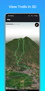
• 3D trail visualization for better route understanding (Pro only)
• Comprehensive route planning
Planning Tools
• Intelligent routing between multiple waypoints
• ETA calculator for trip planning
• Vertical distance measurement for elevation gain tracking
• Coordinate finder for precise location marking
Smart Technology
• Compass
• Dark mode for low-light conditions
• Weather forecasting integration
PERFECT FOR EVERY ADVENTURE
Hiking & Trekking: Navigate mountain trails with confidence using precise elevation data and topographic maps.
Cycling: Track road cycling and mountain biking with detailed performance metrics and route optimization.
Winter Sports: Monitor skiing and snowboarding activities with accurate altitude and speed tracking.
Urban Exploration: Discover walking tours and city adventures with comprehensive mapping tools.
PREMIUM FEATURES
Unlock advanced capabilities with ALTLAS Pro:
• Complete offline map access for remote adventures
• Stunning 3D trail visualization
• Premium satellite and specialized map layers
• Live location sharing for safety and coordination
TECHNICAL EXCELLENCE
GPS Mode: Utilizes high-precision satellite positioning with intelligent correction algorithms for optimal accuracy in outdoor environments.
Barometer Mode: Leverages device sensors for reliable altitude tracking indoors and in challenging GPS conditions.
SUPPORT & COMMUNITY
Join thousands of outdoor enthusiasts in our active community:
• Comprehensive Support Guide: https://altlas-app.com/support.html
• Direct Support: erol1apps@gmail.com
• Official Website: www.altlas-app.com
PRIVACY & SAFETY
ALTLAS respects your privacy and provides tools to enhance your safety outdoors. Location data is processed locally on your device, and sharing features are entirely optional.
Use of this application is at your own discretion and risk. Always carry appropriate safety equipment and inform others of your planned activities.
Ready to elevate your outdoor adventures? Download ALTLAS today and discover why outdoor enthusiasts worldwide trust our navigation technology.
Rate and review ALTLAS to help other adventurers discover the power of professional trail navigation.
Your ultimate companion for outdoor adventures. Navigate trails with precision, track activities comprehensively, and explore new paths with advanced GPS technology and detailed mapping tools.
KEY FEATURES
Advanced Navigation
Track your outdoor activities with professional-grade GPS accuracy and comprehensive trail mapping. Whether you're hiking mountain peaks or cycling through city streets, ALTLAS provides the precision you need.
Comprehensive Activity Support
Record and analyze your hiking, cycling, skiing, and walking adventures with detailed statistics and performance insights.
Rich Trail Database
Access thousands of user-shared routes and contribute your own discoveries to help the outdoor community explore safely.
Dual-Mode Altimeter
Experience accurate elevation tracking both indoors and outdoors with our innovative dual-mode system, combining GPS and barometric sensors for maximum precision.
CORE CAPABILITIES
Navigation & Tracking
• Professional GPS positioning with smart altitude correction
• Real-time activity statistics and performance metrics
• GPX file import and export for route sharing
• Live location sharing for coordination
Mapping & Visualization
• Multiple map types: topographic, satellite (Pro only), OpenStreetMap, and more.
• Offline map support for remote adventures (Pro only)
• 3D trail visualization for better route understanding (Pro only)
• Comprehensive route planning
Planning Tools
• Intelligent routing between multiple waypoints
• ETA calculator for trip planning
• Vertical distance measurement for elevation gain tracking
• Coordinate finder for precise location marking
Smart Technology
• Compass
• Dark mode for low-light conditions
• Weather forecasting integration
PERFECT FOR EVERY ADVENTURE
Hiking & Trekking: Navigate mountain trails with confidence using precise elevation data and topographic maps.
Cycling: Track road cycling and mountain biking with detailed performance metrics and route optimization.
Winter Sports: Monitor skiing and snowboarding activities with accurate altitude and speed tracking.
Urban Exploration: Discover walking tours and city adventures with comprehensive mapping tools.
PREMIUM FEATURES
Unlock advanced capabilities with ALTLAS Pro:
• Complete offline map access for remote adventures
• Stunning 3D trail visualization
• Premium satellite and specialized map layers
• Live location sharing for safety and coordination
TECHNICAL EXCELLENCE
GPS Mode: Utilizes high-precision satellite positioning with intelligent correction algorithms for optimal accuracy in outdoor environments.
Barometer Mode: Leverages device sensors for reliable altitude tracking indoors and in challenging GPS conditions.
SUPPORT & COMMUNITY
Join thousands of outdoor enthusiasts in our active community:
• Comprehensive Support Guide: https://altlas-app.com/support.html
• Direct Support: erol1apps@gmail.com
• Official Website: www.altlas-app.com
PRIVACY & SAFETY
ALTLAS respects your privacy and provides tools to enhance your safety outdoors. Location data is processed locally on your device, and sharing features are entirely optional.
Use of this application is at your own discretion and risk. Always carry appropriate safety equipment and inform others of your planned activities.
Ready to elevate your outdoor adventures? Download ALTLAS today and discover why outdoor enthusiasts worldwide trust our navigation technology.
Rate and review ALTLAS to help other adventurers discover the power of professional trail navigation.
Date de mise à jour
La sécurité, c'est d'abord comprendre comment les développeurs collectent et partagent vos données. Les pratiques concernant leur confidentialité et leur protection peuvent varier selon votre utilisation, votre région et votre âge. Le développeur a fourni ces informations et peut les modifier ultérieurement.


Notes et avis
4,4
3,73K avis
Nouveautés
Fixed a bug that prevented navigation from starting.
Assistance de l'appli
À propos du développeur
Tal Vaknin
vaknintal1@gmail.com
רוקח 92
דירה 4
רמת גן, 5257416
Israel
undefined


