
Russian Topo Maps Pro
5,0star
8,65K avis
50K+
Téléchargements

Tout public
info


À propos de l'application
Offroad navigation app with worldwide topographic maps (mainly Russian general staff maps). There are also many other map layers with up-to-date and detailed maps or aerial photos.
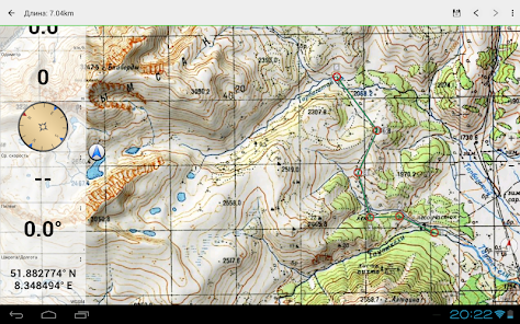
Even though most of the Russian maps date back to the 1980s, they are still among the best topo maps available for many regions in Africa and Asia, especially if you are looking for remote tracks or old infrastructure. All maps are also labelled in English.
Map data can be downloaded so that the application can also be used without internet reception. No user data is collected by the app!
Selectable map layers (worldwide):
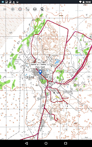
• Topo maps (worldwide coverage 1:100,000 - 1:200,000) Russian General Staff maps - Genshtab
• GGC Gosgiscentr Topo maps Russia 1:25,000 - 1:200,000
• ROSREESTR The Federal Service for State Registration, Cadastre and Cartography (only Russia. Up-to-date and very detailed)
• Yandex Maps: Satellite images, road map. (Online use only!)
• Openstreetmap: excellent maps with different styles as well as shading & contour lines): OSM Topo, OSM Cycle Map (especially for cyclists), OSM Outdoors (for hikers), OSM Landscape
• Google Maps: Satellite images, road and terrain maps. (Online use only!)
• Bing Maps: Satellite images and street map. (Online use only !)
• ESRI Maps: Satellite images, street and terrain map.
All maps can be created as overlays and compared with each other using a transparency slider.
Switchable overlays (worldwide):
• Hillshading
• 20m contour lines
- OpenSeaMap
This app offers all functions for comprehensive outdoor navigation:
• Download of maps for OFFLINE operation (except Google, Bing & Yandex Maps)
• Create waypoints
• GoTo waypoint navigation
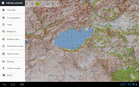
• Create and navigate routes (with automatic route calculation based on OpenStreetMaps)
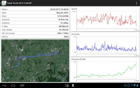
• Track recording (evaluation with speed and altitude profile)
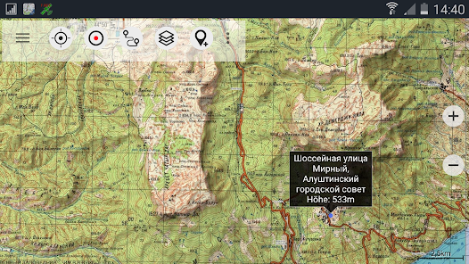
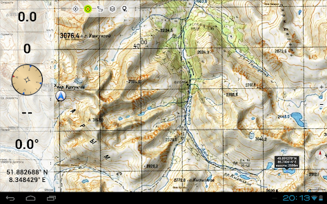
• Freely configurable data fields in the map view (e.g. speed, altitude)
• Tripmaster with fields for daily kilometres, average, distance, compass, etc.
• GPX/KML/KMZ import export
• Search function (locations, POIs, street names)
• Waypoint/track sharing (via e-mail, WhatsApp, ...)
• Measurement of paths and areas
• UMTS/MGRS GRID
Other maps can be imported in common formats:
• GeoPDF
• GeoTiff
• MBTiles
• Ozi (Oziexplorer OZF2 & OZF3)
• Online map services can be integrated as WMS servers or XYZ tile servers.
• OpenStreetMap maps can also be downloaded country by country in space-saving vector format!
For questions please contact support@atlogis.com
Even though most of the Russian maps date back to the 1980s, they are still among the best topo maps available for many regions in Africa and Asia, especially if you are looking for remote tracks or old infrastructure. All maps are also labelled in English.
Map data can be downloaded so that the application can also be used without internet reception. No user data is collected by the app!
Selectable map layers (worldwide):
• Topo maps (worldwide coverage 1:100,000 - 1:200,000) Russian General Staff maps - Genshtab
• GGC Gosgiscentr Topo maps Russia 1:25,000 - 1:200,000
• ROSREESTR The Federal Service for State Registration, Cadastre and Cartography (only Russia. Up-to-date and very detailed)
• Yandex Maps: Satellite images, road map. (Online use only!)
• Openstreetmap: excellent maps with different styles as well as shading & contour lines): OSM Topo, OSM Cycle Map (especially for cyclists), OSM Outdoors (for hikers), OSM Landscape
• Google Maps: Satellite images, road and terrain maps. (Online use only!)
• Bing Maps: Satellite images and street map. (Online use only !)
• ESRI Maps: Satellite images, street and terrain map.
All maps can be created as overlays and compared with each other using a transparency slider.
Switchable overlays (worldwide):
• Hillshading
• 20m contour lines
- OpenSeaMap
This app offers all functions for comprehensive outdoor navigation:
• Download of maps for OFFLINE operation (except Google, Bing & Yandex Maps)
• Create waypoints
• GoTo waypoint navigation
• Create and navigate routes (with automatic route calculation based on OpenStreetMaps)
• Track recording (evaluation with speed and altitude profile)
• Freely configurable data fields in the map view (e.g. speed, altitude)
• Tripmaster with fields for daily kilometres, average, distance, compass, etc.
• GPX/KML/KMZ import export
• Search function (locations, POIs, street names)
• Waypoint/track sharing (via e-mail, WhatsApp, ...)
• Measurement of paths and areas
• UMTS/MGRS GRID
Other maps can be imported in common formats:
• GeoPDF
• GeoTiff
• MBTiles
• Ozi (Oziexplorer OZF2 & OZF3)
• Online map services can be integrated as WMS servers or XYZ tile servers.
• OpenStreetMap maps can also be downloaded country by country in space-saving vector format!
For questions please contact support@atlogis.com
Date de mise à jour
La sécurité, c'est d'abord comprendre comment les développeurs collectent et partagent vos données. Les pratiques concernant leur confidentialité et leur protection peuvent varier selon votre utilisation, votre région et votre âge. Le développeur a fourni ces informations et peut les modifier ultérieurement.

Aucune donnée partagée avec des tiers
En savoir plus sur la manière dont les développeurs déclarent le partage

Aucune donnée collectée
En savoir plus sur la manière dont les développeurs déclarent la collecte

Les données sont chiffrées lors de leur transfert
Notes et avis
5,0
7,87K avis
Nouveautés
・New GGC All layer
・Bug fixes
・Bug fixes
Assistance de l'appli
À propos du développeur
Atlogis Geoinformatics GmbH & Co. KG
support@atlogis.com
Unter den Ulmen 8
33330 Gütersloh
Germany
+49 171 1738949


