
Navitel Navigator GPS & Maps
Ilova ichida xaridlar
3,3star
216 ming ta sharh
10 mln+
Yuklanmalar

Hamma uchun
info


Bu ilova haqida
Navitel Navigator 11 is a precise offline GPS navigation, up-to-date online services, and detailed maps of 67 countries and territories of the world. 7 days free.
ADVANTAGES
• Modern user-friendly interface
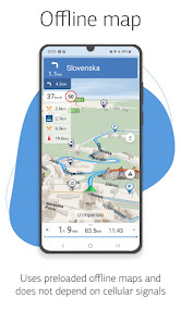
• Offline maps. To work with the program and maps, you do not need the Internet: savings in roaming and independence from the quality of communication in the regions
• Navigation maps with a high level of detail
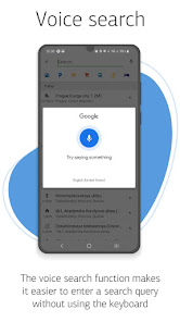
• Voice search
• Easy and convenient POI search by category
• Visual and voice guidance along the route
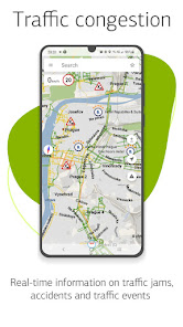
• Actual information about road warnings, potentially dangerous places, speed cameras, road restrictions, etc.
• HUD (Head-Up Display)
• Detailed navigation maps of 67 countries and territories of the world are available for purchase.
SPECIAL FEATURES
• Fast route calculation. Instant calculation and routing of any length and complexity.
• 3 alternative routes with distance and travel time information.
• Navitel.Traffic. Information on all traffic jams in the covered area, available in real-time.
• Navitel.Events. Road accidents, road works, speed cams, and other events marked on the map by users.
• SpeedCam warnings. Information on radars, video recording cameras, and speed bumps.
• 3D Mapping. Three-dimensional maps with texture and number of floors support.
• 3D Road interchanges. Displaying multilevel road interchanges in 3D mode.
• Lane Assist. Route calculations taking multilane traffic into account and visual prompts while following the route
• Turn-by-turn voice guidance while moving along the route.
• Cargo graph: building routes considering road signs for cars from 3.5 - 20 tons, with the ability to customize the parameters of your vehicle and get a route that is relevant for a particular truck.
• Dynamic POI. Fuel prices, movies showtimes, and other useful information.
• Unlimited number of waypoints when building a route. Convenient route planning with an unlimited number of waypoints.
• Multilanguage. Support for interface and voice prompts in 39 languages.
• Customizable user interface. Ability to adapt the program interface and map display mode for your own needs.
• Purchases from the program menu. Purchase of new packs of maps and renewal of those already purchased from the main menu.
• Multitouch support. Quick access to map scaling and rotation functions via the multitouch input.
• Support for two navigation systems - GLONASS and GPS.
If you have any questions contact us: support@navitel.cz. We will be happy to help you.
ADVANTAGES
• Modern user-friendly interface
• Offline maps. To work with the program and maps, you do not need the Internet: savings in roaming and independence from the quality of communication in the regions
• Navigation maps with a high level of detail
• Voice search
• Easy and convenient POI search by category
• Visual and voice guidance along the route
• Actual information about road warnings, potentially dangerous places, speed cameras, road restrictions, etc.
• HUD (Head-Up Display)
• Detailed navigation maps of 67 countries and territories of the world are available for purchase.
SPECIAL FEATURES
• Fast route calculation. Instant calculation and routing of any length and complexity.
• 3 alternative routes with distance and travel time information.
• Navitel.Traffic. Information on all traffic jams in the covered area, available in real-time.
• Navitel.Events. Road accidents, road works, speed cams, and other events marked on the map by users.
• SpeedCam warnings. Information on radars, video recording cameras, and speed bumps.
• 3D Mapping. Three-dimensional maps with texture and number of floors support.
• 3D Road interchanges. Displaying multilevel road interchanges in 3D mode.
• Lane Assist. Route calculations taking multilane traffic into account and visual prompts while following the route
• Turn-by-turn voice guidance while moving along the route.
• Cargo graph: building routes considering road signs for cars from 3.5 - 20 tons, with the ability to customize the parameters of your vehicle and get a route that is relevant for a particular truck.
• Dynamic POI. Fuel prices, movies showtimes, and other useful information.
• Unlimited number of waypoints when building a route. Convenient route planning with an unlimited number of waypoints.
• Multilanguage. Support for interface and voice prompts in 39 languages.
• Customizable user interface. Ability to adapt the program interface and map display mode for your own needs.
• Purchases from the program menu. Purchase of new packs of maps and renewal of those already purchased from the main menu.
• Multitouch support. Quick access to map scaling and rotation functions via the multitouch input.
• Support for two navigation systems - GLONASS and GPS.
If you have any questions contact us: support@navitel.cz. We will be happy to help you.
Oxirgi yangilanish
Xavfsizlik — dastur ishlab chiquvchilar maʼlumotlaringizni qanday jamlashi va ulashishini tushunishdan boshlanadi. Maʼlumotlar maxfiyligi va xavfsizlik amaliyotlari ilovadan foydalanish, hudud va yoshga qarab farq qilishi mumkin. Bu axborot dastur ishlab chiquvchi tomonidan taqdim etilgan va keyinchalik yangilanishi mumkin.

Tashqi hamkorlarga hech qanday axborot ulashilmagan
Dastur ishlab chiquvchilar axborot ulashilishini qanday aytishi haqida batafsil

Ushbu ilova quyidagi axborot turlarini toʻplashi mumkin
Joylashuv, Men haqimda va yana 3 ta

Maʼlumotlar uzatish vaqtida shifrlanadi

Maʼlumotlarni oʻchirishni soʻrashingiz mumkin
Reytinglar va sharhlar
3,1
190 ming ta sharh

SADRIDDIN ASHIROV
- Nomaqbul deb belgilash
1-avgust, 2023
Yaxshi
3 kishi bu sharhni foydali deb topgan
NAVITEL
3-avgust, 2023
Thanks for your feedback and high rate!

Farhodbek
- Nomaqbul deb belgilash
30-iyun, 2021
Хозирча ишлаши яхши, эски версияси анча қулайроқ эди.
8 kishi bu sharhni foydali deb topgan
NAVITEL
30-iyun, 2021
Thank you for your feedback!

Qahramon Kuziyev
- Nomaqbul deb belgilash
3-avgust, 2021
Yaxshi dastur ekan. Ancha yangilanishlar bor ekan.
8 kishi bu sharhni foydali deb topgan
NAVITEL
3-avgust, 2021
Thanks for your feedback and interest to NAVITEL® products!
Nima yangiliklar
What's new:
- Fixed maps download
- Fixed maps download
Ilova yuzasidan yordam
phone
Telefon raqami
+420225852852
Dasturchi haqida
NAVITEL s.r.o.
support@navitel.cz
247/11 U Habrovky
140 00 Praha
Czechia
+420 604 300 669


