

OsmAnd — Maps & GPS Offline
In-app purchases

4.3star
187K reviews
10M+
Downloads

PEGI 3
info


About this app
OsmAnd is an offline world map application based on OpenStreetMap (OSM), which allows you to navigate taking into account the preferred roads and vehicle dimensions. Plan routes based on inclines and record GPX tracks without an internet connection.
OsmAnd is an open source app. We do not collect user data and you decide what data the app will have access to.
Main features:
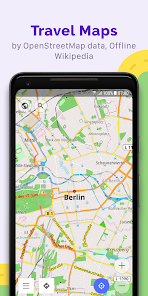
Map view
• Choice of places to be displayed on the map: attractions, food, health and more;
• Search for places by address, name, coordinates, or category;
• Map styles for the convenience of different activities: touring view, nautical map, winter and ski, topographic, desert, off-road, and others;
• Shading relief and plug-in contour lines;
• Ability to overlay different sources of maps on top of each other;
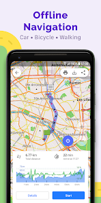
GPS Navigation
• Plotting a route to a place without an Internet connection;
• Customizable navigation profiles for different vehicles: cars, motorcycles, bicycles, 4x4, pedestrians, boats, public transport, and more;
• Change the constructed route, taking into account the exclusion of certain roads or road surfaces;
• Customizable information widgets about the route: distance, speed, remaining travel time, distance to turn, and more;
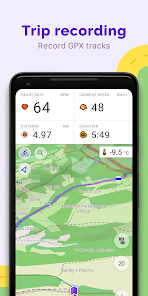
Route Planning and Recording
• Plotting a route point by point using one or multiple navigation profiles;
• Route recording using GPX tracks;
• Manage GPX tracks: displaying your own or imported GPX tracks on the map, navigating through them;
• Visual data about the route - descents/ascents, distances;
• Ability to share GPX track in OpenStreetMap;
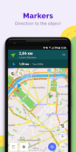
Creation of points with different functionality
• Favourites;
• Markers;
• Audio/video notes;
OpenStreetMap
• Making edits to OSM;
• Updating maps with a frequency of up to one hour;
Additional features
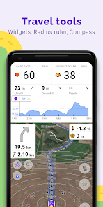
• Compass and radius ruler;
• Mapillary interface;
• Night theme;
• Wikipedia;
• Large community of users around the world, documentation, and support;
Paid features:
Maps+ (in-app or subscription)
• Android Auto support;
• Unlimited map downloads;
• Topo data (Contour lines and Terrain);
• Nautical depths;
• Offline Wikipedia;
• Offline Wikivoyage - Travel guides.
OsmAnd Pro (subscription)
• OsmAnd Cloud (backup and restore);
• Cross-platform;
• Hourly map updates;
• Weather plugin;
• Elevation widget;
• Customise route line;
• External sensors support (ANT+, Bluetooth);
• Online Elevation profile.
OsmAnd is an open source app. We do not collect user data and you decide what data the app will have access to.
Main features:
Map view
• Choice of places to be displayed on the map: attractions, food, health and more;
• Search for places by address, name, coordinates, or category;
• Map styles for the convenience of different activities: touring view, nautical map, winter and ski, topographic, desert, off-road, and others;
• Shading relief and plug-in contour lines;
• Ability to overlay different sources of maps on top of each other;
GPS Navigation
• Plotting a route to a place without an Internet connection;
• Customizable navigation profiles for different vehicles: cars, motorcycles, bicycles, 4x4, pedestrians, boats, public transport, and more;
• Change the constructed route, taking into account the exclusion of certain roads or road surfaces;
• Customizable information widgets about the route: distance, speed, remaining travel time, distance to turn, and more;
Route Planning and Recording
• Plotting a route point by point using one or multiple navigation profiles;
• Route recording using GPX tracks;
• Manage GPX tracks: displaying your own or imported GPX tracks on the map, navigating through them;
• Visual data about the route - descents/ascents, distances;
• Ability to share GPX track in OpenStreetMap;
Creation of points with different functionality
• Favourites;
• Markers;
• Audio/video notes;
OpenStreetMap
• Making edits to OSM;
• Updating maps with a frequency of up to one hour;
Additional features
• Compass and radius ruler;
• Mapillary interface;
• Night theme;
• Wikipedia;
• Large community of users around the world, documentation, and support;
Paid features:
Maps+ (in-app or subscription)
• Android Auto support;
• Unlimited map downloads;
• Topo data (Contour lines and Terrain);
• Nautical depths;
• Offline Wikipedia;
• Offline Wikivoyage - Travel guides.
OsmAnd Pro (subscription)
• OsmAnd Cloud (backup and restore);
• Cross-platform;
• Hourly map updates;
• Weather plugin;
• Elevation widget;
• Customise route line;
• External sensors support (ANT+, Bluetooth);
• Online Elevation profile.
Updated on
Safety starts with understanding how developers collect and share your data. Data privacy and security practices may vary based on your use, region, and age. The developer provided this information and may update it over time.

No data shared with third parties
Learn more about how developers declare sharing

This app may collect these data types
Personal info, Photos and videos and 5 others

Data is encrypted in transit

You can request that data be deleted
Ratings and reviews
4.3
174K reviews

Mikey B
- Flag inappropriate
January 8, 2024
This app is one of the worst I've ever used. Importing a track and/or creating one seems to work, but at the point I actually want to use it for navigation, even with nothing else running, it makes the app crash & freezes my entire phone. If I have Spotify running in the background, OsmAnd will run (briefly) but Spotify won't. I've tried un-installing & re-installing, as well as keeping my phone & app up-to-date. Shame - on the surface it appears great, but in reality for me it's unusable.
13 people found this review helpful
OsmAnd
January 10, 2024
Hello, Mikey! Thank you for the feedback. Could you please provide more details about the issue? You can contact us at support@osmand.net.

Techie Fairy
- Flag inappropriate
- Show review history
December 14, 2023
Edit 14/12/23 - the voice prompt no longer comes through the Bluetooth on my car, and if I'm reading your description properly, this is now a paid feature? If this is correct, it's disgusting. And if it's a bug, how come there's forums full of us all screaming about it, with no fix? Original review 2020 - Detailed, a bit complicated till you get used to it, but it means the options are endless. And, biggest plus of all, it's not Google or Microsoft.
11 people found this review helpful

steve eardley
- Flag inappropriate
July 16, 2023
Great offline navigation app 👍. I've only just started using this app but I can honestly say that It ticks all the boxes for me. The UI is very easy to use so setting it up after installation only takes a few minutes. The maps are extremely well detailed and show locations such as supermarkets, car parks and so on. I can't fault this app at all 👌.
21 people found this review helpful
What's new
• New "Speedometer" widget compatible with Android Auto
• Configure the map screen by adding multiple "Quick Action" buttons
• Improved readability of data in graphs
• Added filters by sensor data for tracks
• Improved appearance customization for group of tracks
• Added support for additional GPX tags
• Customize "Distance during navigation": choose between precise or round up numbers
• Unified UI for track selection
• OpenStreetMap login switched to OAuth 2.0


