
Organic Maps・Offline Map & GPS
4.4star
14.3K reviews
1M+
Downloads

Everyone
info


About this app
Organic Maps is a fast, detailed offline map and GPS navigation app for travel, hiking, trekking, and cycling adventures. Plan, import, and record routes, and enjoy smooth guidance without draining your battery or using an internet connection. Explore places and navigate safely during your outdoor adventures and travels around the world. The app offers unlimited map downloads and biweekly updates. OpenStreetMap-based, volunteer-made, privacy-first, 100% offline, and 100% free.
OFFLINE: The app works 100% offline — including search and navigation. You can explore the map and navigate without an internet connection, saving on mobile data and roaming fees. And with no background data transfers, your battery lasts much longer.
FAST: Zooming, search, and route calculations work noticeably fast.
DETAILED & UPDATED: The maps are rich in detail and refreshed twice a month to reflect real-world conditions. Unlike many well-known competitors, they include building labels, benches, hiking paths, and other helpful information.
OPENSTREETMAP-BASED: OpenStreetMap is a wiki-style world map built and maintained by millions of volunteers — locals who know their areas best. This community effort results in highly detailed maps, often more accurate than commercial ones in less-mapped regions. Organic Maps updates its data from OpenStreetMap every two weeks, keeping your maps fresh and reliable. And if you notice something missing, you can add it to OpenStreetMap and help improve the map for everyone.
PRIVACY-FIRST: We don’t collect any data or identifiers. This means there’s no risk of data leaks and no distractions like ads or noisy notifications — just a clean, private map experience.
IMPORTANT FEATURES
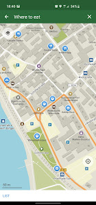
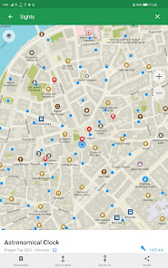
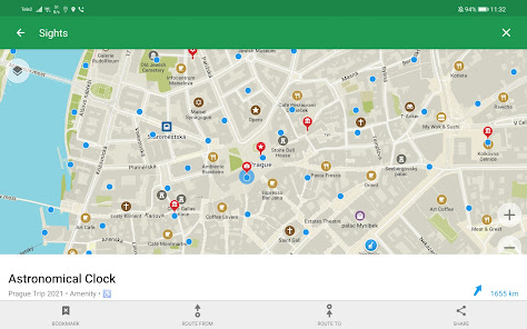
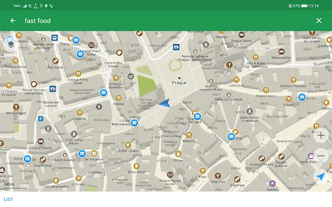
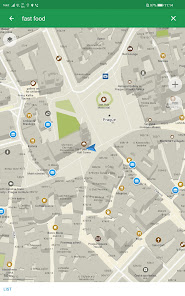
EXPLORE PLACES: Search by address, name, or category, discover millions of POIs, and view detailed information such as opening hours, Wikipedia articles, wheelchair accessibility, and other helpful details.
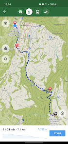
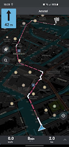
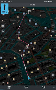
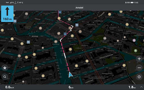
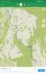
GPS NAVIGATION: Enjoy voice-guided, turn-by-turn directions. Create walking, hiking, cycling, or driving routes — including routes between cities, countries, and multiple waypoints. Find the best routes for your metro journeys and commutes. Android Auto is supported.
HIKING & CYCLING TRAILS FROM AROUND THE WORLD: Enable special map layers to discover popular hiking and cycling routes worldwide, all sourced from OpenStreetMap. Switch between layers to see colored bike and MTB routes, as well as official hiking paths.
PUBLIC TRANSPORT: See public transport route numbers at stops. Live transport schedules and routing are currently in development.
MAP STYLES: Choose map layers that fit your activity — Outdoors, Contour Lines, Hiking, Cycling, or Metro/Subway.
TRACK RECORDER: Record, import, export, and share your routes and favorite places. Supports KML, KMZ, GPX, and GeoJSON formats.
WIKIPEDIA ARTICLES: Explore Wikipedia articles for places you discover on the map. Type “?wiki” in the search to find all places with Wikipedia articles.
MAP EDITOR: Contribute to OpenStreetMap by adding missing places or editing the map directly from Organic Maps.
DARK MODE: Switch to a dark theme for comfortable viewing at night.
Try the app — it’s 100% free, ad-free, fast, and fully offline. Experience reliable GPS navigation for hiking, biking, trekking, and travel anywhere in the world! Enjoy a fast, reliable, and private map experience, and share it with others!
Organic Maps is an indie, community-driven, open-source project with hundreds of contributors who help develop new features, fix issues, translate, and move the project forward.
Join the community on Telegram: @OrganicMapsApp
Or learn other ways to support the project: https://organicmaps.app/contribute/
Your honest feedback and reviews in the store motivate us! We love hearing from you there. Have questions? Please visit the organicmaps.app website for additional details and FAQ
OFFLINE: The app works 100% offline — including search and navigation. You can explore the map and navigate without an internet connection, saving on mobile data and roaming fees. And with no background data transfers, your battery lasts much longer.
FAST: Zooming, search, and route calculations work noticeably fast.
DETAILED & UPDATED: The maps are rich in detail and refreshed twice a month to reflect real-world conditions. Unlike many well-known competitors, they include building labels, benches, hiking paths, and other helpful information.
OPENSTREETMAP-BASED: OpenStreetMap is a wiki-style world map built and maintained by millions of volunteers — locals who know their areas best. This community effort results in highly detailed maps, often more accurate than commercial ones in less-mapped regions. Organic Maps updates its data from OpenStreetMap every two weeks, keeping your maps fresh and reliable. And if you notice something missing, you can add it to OpenStreetMap and help improve the map for everyone.
PRIVACY-FIRST: We don’t collect any data or identifiers. This means there’s no risk of data leaks and no distractions like ads or noisy notifications — just a clean, private map experience.
IMPORTANT FEATURES
EXPLORE PLACES: Search by address, name, or category, discover millions of POIs, and view detailed information such as opening hours, Wikipedia articles, wheelchair accessibility, and other helpful details.
GPS NAVIGATION: Enjoy voice-guided, turn-by-turn directions. Create walking, hiking, cycling, or driving routes — including routes between cities, countries, and multiple waypoints. Find the best routes for your metro journeys and commutes. Android Auto is supported.
HIKING & CYCLING TRAILS FROM AROUND THE WORLD: Enable special map layers to discover popular hiking and cycling routes worldwide, all sourced from OpenStreetMap. Switch between layers to see colored bike and MTB routes, as well as official hiking paths.
PUBLIC TRANSPORT: See public transport route numbers at stops. Live transport schedules and routing are currently in development.
MAP STYLES: Choose map layers that fit your activity — Outdoors, Contour Lines, Hiking, Cycling, or Metro/Subway.
TRACK RECORDER: Record, import, export, and share your routes and favorite places. Supports KML, KMZ, GPX, and GeoJSON formats.
WIKIPEDIA ARTICLES: Explore Wikipedia articles for places you discover on the map. Type “?wiki” in the search to find all places with Wikipedia articles.
MAP EDITOR: Contribute to OpenStreetMap by adding missing places or editing the map directly from Organic Maps.
DARK MODE: Switch to a dark theme for comfortable viewing at night.
Try the app — it’s 100% free, ad-free, fast, and fully offline. Experience reliable GPS navigation for hiking, biking, trekking, and travel anywhere in the world! Enjoy a fast, reliable, and private map experience, and share it with others!
Organic Maps is an indie, community-driven, open-source project with hundreds of contributors who help develop new features, fix issues, translate, and move the project forward.
Join the community on Telegram: @OrganicMapsApp
Or learn other ways to support the project: https://organicmaps.app/contribute/
Your honest feedback and reviews in the store motivate us! We love hearing from you there. Have questions? Please visit the organicmaps.app website for additional details and FAQ
Updated on
Safety starts with understanding how developers collect and share your data. Data privacy and security practices may vary based on your use, region, and age. The developer provided this information and may update it over time.

No data shared with third parties
Learn more about how developers declare sharing

No data collected
Learn more about how developers declare collection
Ratings and reviews
4.4
13.7K reviews

Nick Haddan (Nck)
- Flag inappropriate
November 5, 2025
you need to double check your routes before traveling. I used this to travel to a location for work recently. the location was fairly rural. organic maps wanted me to drive off a cliff to get to my destination. it was a 20 minute delay on my trip that Google maps got me to just fine. the search is pretty abysmal and difficult to use. when using with Android Auto, the map constantly zooms in and out making it difficult to gauge distance to take my next turn.
1 person found this review helpful
Organic Maps
November 7, 2025
Hi Nick! We are very sorry to hear that. Could you please contact us at googleplay@organicmaps.app, attaching a screen recording or screenshot of the issues and describing the problems? It would really help us in investigate it and improve the app!

Ash
- Flag inappropriate
- Show review history
November 3, 2025
This app us pretty good. It doesn't rely on google maps data which is a bonus since most of GPS maps are just google maps with a coat of paint basically. This app also turned me into a Volunteer. Now its accuracy is depending on where you live of course but I do have an idea for a feature that google doesn't have for it to read road speed limits as you drive out loud I ain't too sure if its possible to add but hopefully it is
1 person found this review helpful
Organic Maps
November 7, 2025
Hi Ash! Thank you for your suggestion. Currently, this feature is not available due to limited resources, but we are exploring its addition for the future. We continuously update the app and strive to maintain a free, ad-free, and volunteer-driven experience. :)

H. H.
- Flag inappropriate
July 6, 2022
I have been using this app to navigate around Asia for the last seven years, even in remote areas and countries with poor connectivity. I use it every day, often many times per day, and I love it. The offline maps are great, I can add pins, export pins to share with friends, and there is zero superfluous nonsense. The app is clean, simple, and works well. My one wish: a single-color overlay showing all trains, not just subway, so I can see the cross-country routes. Thank you, creators!
38 people found this review helpful
Organic Maps
July 6, 2022
Public transport is planned )
What’s new
• Highlight downloaded regions, nature reserves, national parks, protected areas, Aboriginal lands, danger areas, lakes on the World map
• Routing supports road closure times
• Fresh OSM maps as of November 9
• Fixed crashes and routing, including Android Auto
• Added watchmakers, student accommodations, travel agencies
• Added support for Slovenian language in search
• Voice directions in Estonian, Galician, Hebrew, and Lithuanian
…more at omaps.org/news
App support
About the developer
Organic Maps OU
googleplay@organicmaps.app
Ravala pst 8-810
10143 Tallinn
Estonia
+372 712 1210


