
OS Maps: Explore hiking trails
Achats via l'appli
3,2star
19,9 k avis
1 M+
Téléchargements

Tout public
info


À propos de l'application
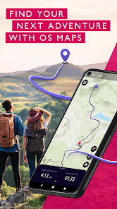
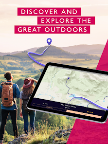
Explore the great outdoors the way you want, all while staying safe with OS Maps. Whether you want to hike, bike or run, OS Maps will guide you with amazing trails across the USA.
Want to find new places in your local neighbourhood? Or plan that next thru-hiking adventure? From breathtaking National Parks to easy walks along the coast, experience the thrill of finding a brand new trail that you never even knew existed with OS Maps. Why you’ll love using OS Maps:
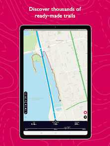
• EXPLORE NEW PLACES, CREATE NEW ADVENTURES
Plan unlimited trails with detailed, up to date maps across the country and discover that next great trail! Whether you love to hike, bike or run, there’s multiple map layers to suit any activity, including topographic and aerial maps.
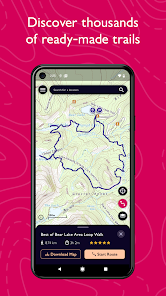
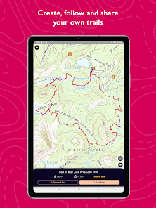
• TRAILS AT YOUR FINGERTIPS
Search for the best trails in an area as rated by fellow outdoor enthusiasts and plot your own trail to follow, share and record.
• VIEW & DOWNLOAD MAPS OFFLINE
No cell reception? No problem. Download your favorite areas to save and view offline – so you can view your maps and routes even without cell reception. Plus, you can export your favourite trails & routes to your GPX device.
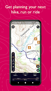
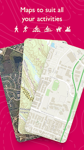
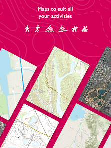
• TRAIL MAPS TO SUIT ANY ACTIVITY
Choose from multiple map layers; plan activities & find trails with detailed topographic mapping; or explore the landscape in stunning detail with aerial view. You can even see the world in 3D on desktop with 3D map layers.
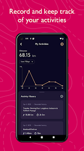
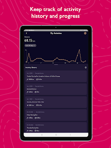
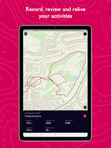
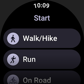
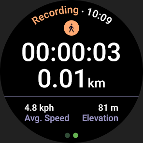
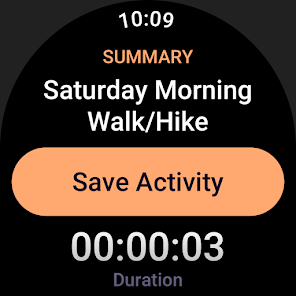
• RECORD, REVIEW & RELIVE ACTIVITIES
Use the activity tracking feature, and activity history dashboard to track each & every adventure. Look back on past activities & review your stats.
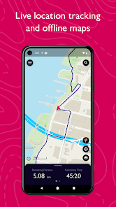
• STAY SAFE ON THE TRAIL
Live GPS location tracking and never miss a turn with off-course alerts will keep you on track. Download trails, routes and maps and share with others.
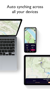
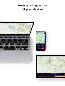
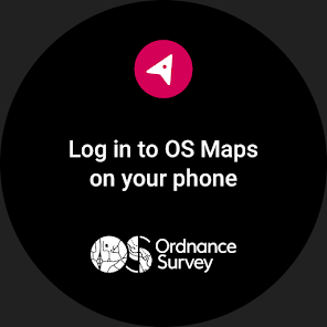
• USE ON EVERY DEVICE
Go from laptop to hilltop with ease! View, create & sync your routes & activities with a single account across multiple devices. Plan on desktop, follow & record your activities on mobile or compatible Wear OS devices.
• PLANNING MADE EASY
Use OS Maps as your off-road GPS tracker with automatic ‘snap-to-path’ making route planning easy with the shortest distance between your waypoints plotted automatically.
• UNLIMITED PRINTING
Print copies of trails and maps to take with you so you always have a backup to hand.
• USEFUL INFO
$4.99 for monthly subscriptions and $28.99 for annual subscriptions
Battery life can be dramatically decreased by using GPS constantly.
We release updates to all of our apps as we improve them, making them even more stable and adding extra features. Along the way, your feedback and comments about those apps are really important to us. If there’s an issue or something you’d like us to know, head to https://www.ordnancesurvey.co.uk/contact-us
OS Maps offers an auto-renewing monthly subscription and an auto-renewing yearly subscription to provide you with premium access to OS Maps while you maintain an active subscription. If you chose to purchase a premium subscription, your payment will be processed by Google.
Subscriptions may be managed through the Google Play App after purchase. Subscriptions on Google Play are renewed automatically unless you unsubscribe at least 24-hours before the end of the current period. Your Google account will be charged for renewal no more than 24 hours before to the end of the current period. You may cancel a subscription at any time before the end of the applicable billing period by going to your Subscriptions list on the Google Play App.
Terms and conditions: http://os.uk/termsosmaps
Privacy policy: http://os.uk/privacy
Want to find new places in your local neighbourhood? Or plan that next thru-hiking adventure? From breathtaking National Parks to easy walks along the coast, experience the thrill of finding a brand new trail that you never even knew existed with OS Maps. Why you’ll love using OS Maps:
• EXPLORE NEW PLACES, CREATE NEW ADVENTURES
Plan unlimited trails with detailed, up to date maps across the country and discover that next great trail! Whether you love to hike, bike or run, there’s multiple map layers to suit any activity, including topographic and aerial maps.
• TRAILS AT YOUR FINGERTIPS
Search for the best trails in an area as rated by fellow outdoor enthusiasts and plot your own trail to follow, share and record.
• VIEW & DOWNLOAD MAPS OFFLINE
No cell reception? No problem. Download your favorite areas to save and view offline – so you can view your maps and routes even without cell reception. Plus, you can export your favourite trails & routes to your GPX device.
• TRAIL MAPS TO SUIT ANY ACTIVITY
Choose from multiple map layers; plan activities & find trails with detailed topographic mapping; or explore the landscape in stunning detail with aerial view. You can even see the world in 3D on desktop with 3D map layers.
• RECORD, REVIEW & RELIVE ACTIVITIES
Use the activity tracking feature, and activity history dashboard to track each & every adventure. Look back on past activities & review your stats.
• STAY SAFE ON THE TRAIL
Live GPS location tracking and never miss a turn with off-course alerts will keep you on track. Download trails, routes and maps and share with others.
• USE ON EVERY DEVICE
Go from laptop to hilltop with ease! View, create & sync your routes & activities with a single account across multiple devices. Plan on desktop, follow & record your activities on mobile or compatible Wear OS devices.
• PLANNING MADE EASY
Use OS Maps as your off-road GPS tracker with automatic ‘snap-to-path’ making route planning easy with the shortest distance between your waypoints plotted automatically.
• UNLIMITED PRINTING
Print copies of trails and maps to take with you so you always have a backup to hand.
• USEFUL INFO
$4.99 for monthly subscriptions and $28.99 for annual subscriptions
Battery life can be dramatically decreased by using GPS constantly.
We release updates to all of our apps as we improve them, making them even more stable and adding extra features. Along the way, your feedback and comments about those apps are really important to us. If there’s an issue or something you’d like us to know, head to https://www.ordnancesurvey.co.uk/contact-us
OS Maps offers an auto-renewing monthly subscription and an auto-renewing yearly subscription to provide you with premium access to OS Maps while you maintain an active subscription. If you chose to purchase a premium subscription, your payment will be processed by Google.
Subscriptions may be managed through the Google Play App after purchase. Subscriptions on Google Play are renewed automatically unless you unsubscribe at least 24-hours before the end of the current period. Your Google account will be charged for renewal no more than 24 hours before to the end of the current period. You may cancel a subscription at any time before the end of the applicable billing period by going to your Subscriptions list on the Google Play App.
Terms and conditions: http://os.uk/termsosmaps
Privacy policy: http://os.uk/privacy
Date de mise à jour
La sécurité, c'est d'abord comprendre comment les développeurs collectent et partagent vos données. Les pratiques concernant leur confidentialité et leur protection peuvent varier selon votre utilisation, votre région et votre âge. Le développeur a fourni ces informations et peut les modifier ultérieurement.

Cette appli peut partager ces types de données avec des tiers
Activité dans l'application et Infos et performance des applis

Cette appli peut recueillir ces types de données
Position, Forme et santé et 2 autres

Les données sont chiffrées lors de leur transfert

Vous pouvez demander la suppression des données
Notes et avis
3,2
18,6 k avis

Arnaud Venot
- Signaler un avis inapproprié
- Afficher l'historique de l'avis
22 février 2024
J'ai peut d'expérience sur cette application, mais mon ami me l'a fortement recommandée. Merci
2 personnes ont trouvé cet avis utile
Ordnance Survey Ltd
16 octobre 2023
HI Arnaud, you are right you will need to register but this is free to do. This is so you can create and save routes and use the OS Maps free functionality fully, as you require an account to save these to. I hope this helps to explain why we include this sign up process.

julien puginier
- Signaler un avis inapproprié
5 mai 2024
Doesn't work, I can't log in, always says I'm offline even if I'm not. Useless
1 personne a trouvé cet avis utile
Ordnance Survey Ltd
7 mai 2024
We are aware that there was an issue affecting the availability of OS Maps between Sunday 5th May & Monday 6th May which meant you were unable to access mapping. We can confirm that this issue is now resolved.
We apologise for any inconvenience caused during this outage and thank you for your patience.

Zakaria Ali
- Signaler un avis inapproprié
17 septembre 2022
Nice one
3 personnes ont trouvé cet avis utile
Ordnance Survey Ltd
23 septembre 2022
Thank you for the 5 star review!
Nouveautés
This latest release includes improvements to performance and introduces a map scale which can be seen in the bottom left when viewing the map.


