

OsmAnd — Maps & GPS Offline
In-app purchases

4,4star
228K reviews
10M+
Downloads

Everyone
info


About this app
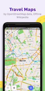
OsmAnd is an offline world map application based on OpenStreetMap (OSM), which allows you to navigate taking into account the preferred roads and vehicle dimensions. Plan routes based on inclines and record GPX tracks without an internet connection.
OsmAnd is an open source app. We do not collect user data and you decide what data the app will have access to.
Main features:
Map view
• Choice of places to be displayed on the map: attractions, food, health and more;
• Search for places by address, name, coordinates, or category;
• Map styles for the convenience of different activities: touring view, nautical map, winter and ski, topographic, desert, off-road, and others;
• Shading relief and plug-in contour lines;
• Ability to overlay different sources of maps on top of each other;
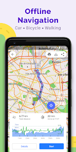
GPS Navigation
• Plotting a route to a place without an Internet connection;
• Customizable navigation profiles for different vehicles: cars, motorcycles, bicycles, 4x4, pedestrians, boats, public transport, and more;
• Change the constructed route, taking into account the exclusion of certain roads or road surfaces;
• Customizable information widgets about the route: distance, speed, remaining travel time, distance to turn, and more;
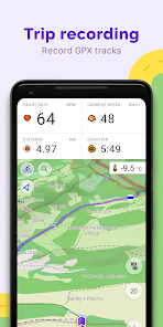
Route Planning and Recording
• Plotting a route point by point using one or multiple navigation profiles;
• Route recording using GPX tracks;
• Manage GPX tracks: displaying your own or imported GPX tracks on the map, navigating through them;
• Visual data about the route - descents/ascents, distances;
• Ability to share GPX track in OpenStreetMap;
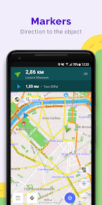
Creation of points with different functionality
• Favourites;
• Markers;
• Audio/video notes;
OpenStreetMap
• Making edits to OSM;
• Updating maps with a frequency of up to one hour;
Additional features
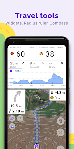
• Compass and radius ruler;
• Mapillary interface;
• Night theme;
• Wikipedia;
• Large community of users around the world, documentation, and support;
Paid features:
Maps+ (in-app or subscription)
• Android Auto support;
• Unlimited map downloads;
• Topo data (Contour lines and Terrain);
• Nautical depths;
• Offline Wikipedia;
• Offline Wikivoyage - Travel guides.
OsmAnd Pro (subscription)
• OsmAnd Cloud (backup and restore);
• Cross-platform;
• Hourly map updates;
• Weather plugin;
• Elevation widget;
• Customise route line;
• External sensors support (ANT+, Bluetooth);
• Online Elevation profile.
OsmAnd is an open source app. We do not collect user data and you decide what data the app will have access to.
Main features:
Map view
• Choice of places to be displayed on the map: attractions, food, health and more;
• Search for places by address, name, coordinates, or category;
• Map styles for the convenience of different activities: touring view, nautical map, winter and ski, topographic, desert, off-road, and others;
• Shading relief and plug-in contour lines;
• Ability to overlay different sources of maps on top of each other;
GPS Navigation
• Plotting a route to a place without an Internet connection;
• Customizable navigation profiles for different vehicles: cars, motorcycles, bicycles, 4x4, pedestrians, boats, public transport, and more;
• Change the constructed route, taking into account the exclusion of certain roads or road surfaces;
• Customizable information widgets about the route: distance, speed, remaining travel time, distance to turn, and more;
Route Planning and Recording
• Plotting a route point by point using one or multiple navigation profiles;
• Route recording using GPX tracks;
• Manage GPX tracks: displaying your own or imported GPX tracks on the map, navigating through them;
• Visual data about the route - descents/ascents, distances;
• Ability to share GPX track in OpenStreetMap;
Creation of points with different functionality
• Favourites;
• Markers;
• Audio/video notes;
OpenStreetMap
• Making edits to OSM;
• Updating maps with a frequency of up to one hour;
Additional features
• Compass and radius ruler;
• Mapillary interface;
• Night theme;
• Wikipedia;
• Large community of users around the world, documentation, and support;
Paid features:
Maps+ (in-app or subscription)
• Android Auto support;
• Unlimited map downloads;
• Topo data (Contour lines and Terrain);
• Nautical depths;
• Offline Wikipedia;
• Offline Wikivoyage - Travel guides.
OsmAnd Pro (subscription)
• OsmAnd Cloud (backup and restore);
• Cross-platform;
• Hourly map updates;
• Weather plugin;
• Elevation widget;
• Customise route line;
• External sensors support (ANT+, Bluetooth);
• Online Elevation profile.
Updated on
Safety starts with understanding how developers collect and share your data. Data privacy and security practices may vary based on your use, region and age. The developer provided this information and may update it over time.

No data shared with third parties
Learn more about how developers declare sharing

This app may collect these data types
Personal info, Photos and videos and 5 others

Data is encrypted in transit

You can request that data be deleted
Ratings and reviews
4,4
213K reviews

G Oakley
- Flag inappropriate
06 October 2024
Fair map app. No address look up, just destination road & cross streets. Choosing destination on the map, but it may not show. Showed 2 houses on a street where there are 12. Routing is ok, does not look at traffic, says trip is 25mi. in 28 min., hour is likely. Rereroutes when you turn off. Sticks to major roads but suggest to many U-turns when changing path. Places are out of date by up to 5 yrs & some all out wrong, never had that name. Audio is good, some nice options there too. But ...
33 people found this review helpful
OsmAnd
07 October 2024
Hello! Thank you for the feedback.
We use OpenStreetMap as a source of data. This map is built by a community of volunteers, availability of data in some areas depends on the number of volunteers. If you have any other questions please contact us at support@osmand.net

Slade
- Flag inappropriate
02 November 2025
I have yet to try fully try the app out. I'm still setting it up. That said, they've already scored major points with me. other developers need to take notes on this. To use premium features, it will cost you $2.99/month, $29.99/yr, for a one-time fee of $39.99. I've already blacklisted other apps, regardless of their usefulness, for only giving me the option to purchase a one-year subscription. Good job, guys. 👍😎
8 people found this review helpful
OsmAnd
06 November 2025
Hello, Slade! Thank you for the feedback.

Jay Celani
- Flag inappropriate
30 August 2025
So far, it's a pretty awful app. Just tried my first track recording - after 2 miles, didn't record anything, though I started the recorder. The app is the opposite of intuitive or user-friendly. All I want to do is create a gps track so I can map trails. Seems like the simplest and most common use - that function should be very simple to get to and run, but in this awful app, it's not. I'll try it again once more, but I'm dubious.
3 people found this review helpful
OsmAnd
01 September 2025
Hello, Jay! Thank you for the feedback.
Please try to disable the energy-saving mode for OsmAnd, as it often closes apps running in the background. If this doesn't help, please contact us at support@osmand.net.
What's new
• Added street and city details to search results
• New Trip Recording widgets: Max Speed, Average Slope, and improved Uphill/Downhill
• New "Marine" nautical map style with extensive customization options
• Improved map rendering speed
• Enhanced connectivity with OBDII BLE adapters
• Added heart rate metrics to the "Analyze by Interval"
• Added duration display for planned tracks
• Altitude units can now be set separately from distance units
App support
About the developer
OsmAND B.V.
victor.shcherb@osmand.net
Logger 41
1186 RM Amstelveen
Netherlands
+31 6 19804549


